The hill fort
The fort's walls climb the boulder-covered hill in successive rings. On the poster the hill is a broad open shape with only a few paths, which sets it clearly apart from the town below.
ቀላል ንድፍ ያለው የካርታ ፖስተር · ህንድ
14.2226° N / 76.4004° E
A town wrapped around a granite hill fort, where boulder-strewn slopes and rings of stone walls push the streets outward.




አንድ ከተማ፣ አምስት ስሜቶች
ዘይቤ በመንካት በግድግዳ ላይ ይመልከቱት። ሁሉም ዘይቤዎች ተመሳሳይ ዋጋ አላቸው — የታተመ፣ በፍሬም የተደረገ ወይም እንደ HD ፋይል።
 ትክክለኛ ፒክሰሎች · 24 × 36″ የህትመት ፋይል
ለህትመት ጥርት ያለ
ይህ ከትክክለኛው የህትመት ፋይል 100% የተቆረጠ ክፍል ነው። እያንዳንዱ ፖስተር — የታተመ፣ በፍሬም የተደረገ ወይም የወረደ — በእኛ አገልጋዮች ላይ በ300 DPI፣ እስከ 7,200 × 10,800 ፒክሰሎች ይሠራል፣ ስለዚህ በ24 × 36″ ህትመት ላይ እንኳን ትንንሾቹ መንገዶች ግልጽ ሆነው ይቆያሉ።
በግድግዳ ላይ


ካርታው
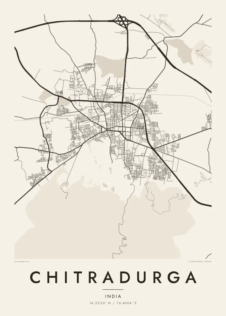
Chitradurga, a district headquarters in central Karnataka, grew at the foot of a rocky hill covered in enormous granite boulders. Crowning it is Chitradurga Fort, a stone fortress built up over several centuries and strengthened by the Nayaka rulers of the region. On a map the fort shows as a large, nearly empty area of hillside, with the town's streets crowded tightly around its lower edge.
The fort is known locally as Elu Suttina Kote, the fort of seven rounds, after its concentric lines of walls. One of the town's best-known stories concerns Onake Obavva, a woman remembered for defending a gap in the walls with a wooden pestle during a siege in the eighteenth century. The national highway between Bengaluru and Pune passes close to the town.
A Chitradurga map poster brings out an unusual composition. Where most towns have a dense centre, this one has a hollow of rock and ramparts surrounded by streets. In black and white the contrast is sharp: dense lanes on one side, the pale mass of the hill on the other, and the lines of fortification between them.
The fort's walls climb the boulder-covered hill in successive rings. On the poster the hill is a broad open shape with only a few paths, which sets it clearly apart from the town below.
The streets closest to the fort are narrow and irregular, following the curve of the hill's base. They are the most densely drawn part of the map.
The main highway runs past the town as a long, straight line. Its rigid course contrasts with the curving streets and the rough outline of the hill.
የራስዎ ያድርጉት
ቀን፣ ስም ወይም የራስዎን ጽሑፍ ያክሉ፤ ስታይልን፣ መጠንን ወይም አቅጣጫን ይቀይሩ።
ነፃው ቅድመ-እይታ ዝቅተኛ ጥራት ያለው እና የውሃ ምልክት ያለበት ነው። ህትመቶች እና HD ፋይሎች በ300 DPI፣ እስከ 7,200 × 10,800 px፣ ያለ ውሃ ምልክት ይሠራሉ።
ለምን Chitradurga
Chitradurga is a strong choice for anyone with roots in the district, or for travellers who climbed the fort and remember the view over the rooftops. It reads well at larger sizes, where the rings of walls and the dense old streets have room to show.
The title, subtitle and coordinates line can all be changed, so the poster can name a family home, a college year or a special date. Choose one of five styles: Classic black & white, Noir, Paper, Blueprint or Sand. Noir makes the pale hill stand out especially clearly.
የChitradurga ፖስተር ይዘዙ| የህትመት መጠን | ጥራት | ፋይሎች |
|---|---|---|
| 30 × 40 cm (11.8 × 15.7″) | 3,543 × 4,724 px | PNG · PDF |
| 29.7 × 42 cm (A3, 11.7 × 16.5″) | 3,508 × 4,961 px | PNG · PDF |
| 42 × 59.4 cm (A2, 16.5 × 23.4″) | 4,961 × 7,016 px | PNG · PDF |
| 45.7 × 61 cm (18 × 24″) | 5,400 × 7,200 px | PNG · PDF |
| 50 × 70 cm (19.7 × 27.6″) | 5,906 × 8,268 px | PNG · PDF |
| 61 × 91.4 cm (24 × 36″) | 7,200 × 10,800 px | PNG · PDF |
ለማነጻጸር፣ ነፃው ቅድመ እይታ 900 px ስፋት ያለው፣ የውሃ ምልክት ያለበት እና ለስክሪን የታሰበ ነው። HD ፋይሎቹ በእያንዳንዱ አቅጣጫ እስከ 8 እጥፍ ጥራት አላቸው፤ በሙሉ የፖስተር መጠንም በንጽህና ይታተማሉ።
በገጹ የላይኛው ክፍል ላይ ዘይቤ ይምረጡ፣ ከዚያም የታተመ ፖስተር — መጠን እና ካስፈለገ ፍሬም — ወይም ዲጂታል HD ፋይሎችን ይምረጡ። ክፍያው በአንድ ደረጃ ይጠናቀቃል፣ ክፍያው እንደተጠናቀቀ የትዕዛዝ ገጽዎ ወዲያውኑ ይዘምናል።
በስድስት መጠኖች ውስጥ በአንዱ፣ ከ30 × 40 ሴ.ሜ እስከ 24 × 36″ ባለ ከፍተኛ ጥራት 200 gsm ማት ወረቀት ላይ ይታተማል። የታተሙ ፖስተሮች ከ$39 ጀምሮ ናቸው፣ ማጓጓዣን ጨምሮ።
አዎ። ጠንካራ የእንጨት ፍሬም በጥቁር፣ በነጭ፣ በተፈጥሯዊ ኦክ ወይም በጥቁር እንጨት ይምረጡ። የማይሰበር መስታወት ያለው ሲሆን ወዲያውኑ ለመስቀል ዝግጁ ነው። በፍሬም የተደረጉ ፖስተሮች ከ$99 ጀምሮ ናቸው፣ ማጓጓዣን ጨምሮ።
ማጓጓዣ በመላው ዓለም ነፃ ነው። እያንዳንዱ ፖስተር ከ30+ አገሮች ውስጥ በሚገኙ የሕትመት አጋሮቻችን መካከል ለእርስዎ በጣም ቅርብ በሆነው ይታተማል፤ አብዛኛውን ጊዜ በ3–7 የሥራ ቀናት ውስጥ ይደርሳል። ሁኔታውንና የመከታተያ መረጃውን በ«ትዕዛዞቼ» ውስጥ ማየት ይችላሉ። ጥቂት አገሮች ከ2–5 ሳምንታት ይወስዳሉ፤ እስካሁን በማንልክባቸው አገሮች ደግሞ ከመክፈልዎ በፊት ድረ ገጹ ያሳውቅዎታል።
በደረሰ በ14 ቀናት ውስጥ ፎቶ ይላኩልን፣ በነፃ እንደግመዋለን ወይም ገንዘብዎን እንመልሳለን።
አዎ። በዚህ ገጽ ላይ ባለው አርታኢ ውስጥ፣ ርዕሱን፣ ንዑስ ርዕሱን እና የመጋጠሚያ መስመሩን እንደፈለጉት ይቀይሩ፣ ዘይቤ እና መጠን ይምረጡ። የታተሙ፣ በፍሬም የተደረጉ እና ዲጂታል ትዕዛዞች ሁሉም የእርስዎን ንድፍ በትክክል ይጠቀማሉ።
በ$9 በ300 DPI PNG እና ለህትመት ዝግጁ የሆኑ PDF ፋይሎችን በሁሉም ስድስት መጠኖች፣ ያለ ውሃ ምልክት፣ በየትኛውም ቦታ ለማተም ያገኛሉ። እርግጠኛ ካልሆኑ? መጀመሪያ ነፃ የውሃ ምልክት ያለበት ቅድመ-እይታ ያውርዱ።
