The Nahe valley
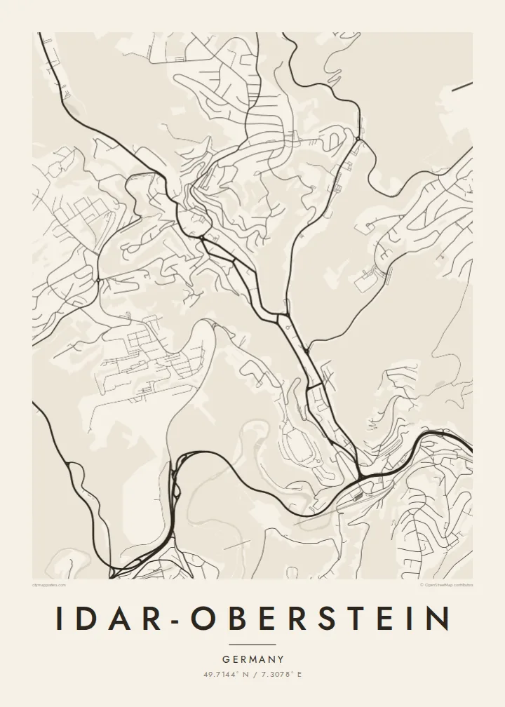
The river bends through a deep valley, and the town lines both banks in a thin continuous strip, giving the map a strong, flowing diagonal from one edge to the other.
ቀላል ንድፍ ያለው የካርታ ፖስተር · ጀርመን
49.7144° N / 7.3078° E
A long, narrow town threaded through the steep Nahe valley, its streets squeezed between wooded slopes and river




አንድ ከተማ፣ አምስት ስሜቶች
ዘይቤ በመንካት በግድግዳ ላይ ይመልከቱት። ሁሉም ዘይቤዎች ተመሳሳይ ዋጋ አላቸው — የታተመ፣ በፍሬም የተደረገ ወይም እንደ HD ፋይል።
 ትክክለኛ ፒክሰሎች · 24 × 36″ የህትመት ፋይል
ለህትመት ጥርት ያለ
ይህ ከትክክለኛው የህትመት ፋይል 100% የተቆረጠ ክፍል ነው። እያንዳንዱ ፖስተር — የታተመ፣ በፍሬም የተደረገ ወይም የወረደ — በእኛ አገልጋዮች ላይ በ300 DPI፣ እስከ 7,200 × 10,800 ፒክሰሎች ይሠራል፣ ስለዚህ በ24 × 36″ ህትመት ላይ እንኳን ትንንሾቹ መንገዶች ግልጽ ሆነው ይቆያሉ።
በግድግዳ ላይ


ካርታው
Idar-Oberstein stretches along the valley of the Nahe in the Hunsrück uplands of Rhineland-Palatinate, and its map looks more like a ribbon than a circle. The town follows the river for several kilometres, with steep, forested hillsides pressing in from both sides. Side valleys, including that of the Idarbach, branch off to the north and carry their own lines of houses and roads.
The present town was formed in 1933 by joining Idar and Oberstein, along with neighbouring communities, which explains its elongated shape and its several distinct centres. In the middle of town the main road runs directly above the Nahe for a stretch, so the river partly disappears from view at street level, a detail that makes the valley floor look unusually crowded on the map.
Idar-Oberstein is known across Europe as a centre of gemstone and agate cutting, a craft rooted in local deposits and later sustained by imported stones. Above Oberstein, the Felsenkirche, a church built into a rock face, overlooks the valley. An Idar-Oberstein map poster records how a town of stone-cutters fitted itself into a narrow, winding river valley.
The river bends through a deep valley, and the town lines both banks in a thin continuous strip, giving the map a strong, flowing diagonal from one edge to the other.
In the centre, the main road is built over the Nahe for a section of its course, so the river line vanishes beneath traffic, an unusual feature in any German town plan.
Tributary valleys such as the Idarbach open off the main valley, each carrying a finger of streets uphill and giving the town its branching, tree-like outline.
የራስዎ ያድርጉት
ቀን፣ ስም ወይም የራስዎን ጽሑፍ ያክሉ፤ ስታይልን፣ መጠንን ወይም አቅጣጫን ይቀይሩ።
ነፃው ቅድመ-እይታ ዝቅተኛ ጥራት ያለው እና የውሃ ምልክት ያለበት ነው። ህትመቶች እና HD ፋይሎች በ300 DPI፣ እስከ 7,200 × 10,800 px፣ ያለ ውሃ ምልክት ይሠራሉ።
ለምን Idar-Oberstein
The narrow valley shape makes Idar-Oberstein a distinctive map to frame, and it carries meaning for people with ties to the gemstone trade, the Hunsrück or the soldiers and families who have lived nearby. It reads as both a place portrait and a study of landscape.
Personalise the title, subtitle and coordinates line with a name or a date, and choose Classic black and white, Noir, Paper, Blueprint or Sand. The $9 digital files include six sizes as 300 DPI PNG and print-ready PDF, without a watermark. Printed and framed posters are also available.
የIdar-Oberstein ፖስተር ይዘዙ| የህትመት መጠን | ጥራት | ፋይሎች |
|---|---|---|
| 30 × 40 cm11.8 × 15.7″ | 3,543 × 4,724 px | PNG · PDF |
| 29.7 × 42 cm (A3)11.7 × 16.5″ | 3,508 × 4,961 px | PNG · PDF |
| 42 × 59.4 cm (A2)16.5 × 23.4″ | 4,961 × 7,016 px | PNG · PDF |
| 45.7 × 61 cm18 × 24″ | 5,400 × 7,200 px | PNG · PDF |
| 50 × 70 cm19.7 × 27.6″ | 5,906 × 8,268 px | PNG · PDF |
| 61 × 91.4 cm24 × 36″ | 7,200 × 10,800 px | PNG · PDF |
ለማነጻጸር፣ ነፃው ቅድመ እይታ 900 px ስፋት ያለው፣ የውሃ ምልክት ያለበት እና ለስክሪን የታሰበ ነው። HD ፋይሎቹ በእያንዳንዱ አቅጣጫ እስከ 8 እጥፍ ጥራት አላቸው፤ በሙሉ የፖስተር መጠንም በንጽህና ይታተማሉ።
በገጹ የላይኛው ክፍል ላይ ዘይቤ ይምረጡ፣ ከዚያም የታተመ ፖስተር — መጠን እና ካስፈለገ ፍሬም — ወይም ዲጂታል HD ፋይሎችን ይምረጡ። ክፍያው በአንድ ደረጃ ይጠናቀቃል፣ ክፍያው እንደተጠናቀቀ የትዕዛዝ ገጽዎ ወዲያውኑ ይዘምናል።
በስድስት መጠኖች ውስጥ በአንዱ፣ ከ30 × 40 ሴ.ሜ እስከ 24 × 36″ ባለ ከፍተኛ ጥራት 200 gsm ማት ወረቀት ላይ ይታተማል። የታተሙ ፖስተሮች ከ$39 ጀምሮ ናቸው፣ ማጓጓዣን ጨምሮ።
አዎ። ጠንካራ የእንጨት ፍሬም በጥቁር፣ በነጭ፣ በተፈጥሯዊ ኦክ ወይም በጥቁር እንጨት ይምረጡ። የማይሰበር መስታወት ያለው ሲሆን ወዲያውኑ ለመስቀል ዝግጁ ነው። በፍሬም የተደረጉ ፖስተሮች ከ$99 ጀምሮ ናቸው፣ ማጓጓዣን ጨምሮ።
ወደ 60+ አገሮች መላኪያ ነፃ ነው። እያንዳንዱ ፖስተር በ30+ አገሮች ካሉ የህትመት አጋሮቻችን በአቅራቢያዎ ባለው ይታተማል፤ አብዛኛውን ጊዜ በ3–7 የሥራ ቀናት ውስጥ ይደርሳል። ሁኔታውንና መከታተያውን በ«የእኔ ትዕዛዞች» ውስጥ ማየት ይችላሉ። ጥቂት አገሮች ከ2–5 ሳምንታት ይወስዳሉ፤ እስካሁን በማንልክበት አገር ደግሞ ከመክፈልዎ በፊት ድረ-ገጹ ያሳውቅዎታል።
በደረሰ በ14 ቀናት ውስጥ ፎቶ ይላኩልን፣ በነፃ እንደግመዋለን ወይም ገንዘብዎን እንመልሳለን።
አዎ። በዚህ ገጽ ላይ ባለው አርታኢ ውስጥ፣ ርዕሱን፣ ንዑስ ርዕሱን እና የመጋጠሚያ መስመሩን እንደፈለጉት ይቀይሩ፣ ዘይቤ እና መጠን ይምረጡ። የታተሙ፣ በፍሬም የተደረጉ እና ዲጂታል ትዕዛዞች ሁሉም የእርስዎን ንድፍ በትክክል ይጠቀማሉ።
በ$9 በ300 DPI PNG እና ለህትመት ዝግጁ የሆኑ PDF ፋይሎችን በሁሉም ስድስት መጠኖች፣ ያለ ውሃ ምልክት፣ በየትኛውም ቦታ ለማተም ያገኛሉ። እርግጠኛ ካልሆኑ? መጀመሪያ ነፃ የውሃ ምልክት ያለበት ቅድመ-እይታ ያውርዱ።
