Paseo de la Reforma
A broad avenue running diagonally from the edge of the centre to Chapultepec and beyond, punctuated by roundabouts and monuments, and one of the strongest lines on the map.
ቀላል ንድፍ ያለው የካርታ ፖስተር · ሜክሲኮ
19.4285° N / 99.1277° W
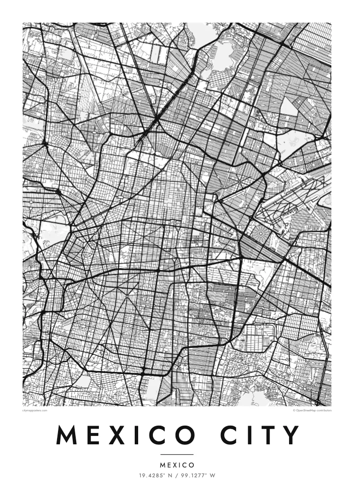
A high valley city built on a drained lakebed, crossed by the long diagonal of Paseo de la Reforma


አንድ ከተማ፣ አምስት ስሜቶች
ዘይቤ በመንካት በግድግዳ ላይ ይመልከቱት። ሁሉም ዘይቤዎች ተመሳሳይ ዋጋ አላቸው — የታተመ፣ በፍሬም የተደረገ ወይም እንደ HD ፋይል።
 ትክክለኛ ፒክሰሎች · 24 × 36″ የህትመት ፋይል
ለህትመት ጥርት ያለ
ይህ ከትክክለኛው የህትመት ፋይል 100% የተቆረጠ ክፍል ነው። እያንዳንዱ ፖስተር — የታተመ፣ በፍሬም የተደረገ ወይም የወረደ — በእኛ አገልጋዮች ላይ በ300 DPI፣ እስከ 7,200 × 10,800 ፒክሰሎች ይሠራል፣ ስለዚህ በ24 × 36″ ህትመት ላይ እንኳን ትንንሾቹ መንገዶች ግልጽ ሆነው ይቆያሉ።
በግድግዳ ላይ


ካርታው
Mexico City sits in a high basin at about 2,240 metres, ringed by mountains and volcanoes. Much of it stands on the bed of Lake Texcoco, drained over the centuries after the Spanish conquest. The historic centre occupies the site of Tenochtitlan, the Aztec capital built on an island, and its grid of streets is still organised around the vast open square of the Zócalo.
West of the centre, Paseo de la Reforma cuts diagonally toward Chapultepec, a large wooded park with a hill, lakes and a castle. Nearby, neighbourhoods such as Roma and Condesa show curving streets and small plazas, while the Circuito Interior and the Periférico loop around the core. To the south, the canals of Xochimilco preserve a fragment of the old lake landscape.
Because it rests on soft lake clay, parts of the city have sunk by several metres over the past century. The historic centre and Xochimilco were inscribed together as a UNESCO World Heritage Site in 1987. A Mexico City map poster shows the old lake city beneath the modern grid, with Reforma, Chapultepec and the Zócalo as clear reference points.
A broad avenue running diagonally from the edge of the centre to Chapultepec and beyond, punctuated by roundabouts and monuments, and one of the strongest lines on the map.
One of the largest urban parks in the Americas, shown as a wide open area west of the centre with winding paths, lakes and the hill that gives it its name.
In the south, a network of narrow canals around chinampas, the traditional raised farm plots, recalls the lakes that once filled the whole valley.
የራስዎ ያድርጉት
ቀን፣ ስም ወይም የራስዎን ጽሑፍ ያክሉ፤ ስታይልን፣ መጠንን ወይም አቅጣጫን ይቀይሩ።
ነፃው ቅድመ-እይታ ዝቅተኛ ጥራት ያለው እና የውሃ ምልክት ያለበት ነው። ህትመቶች እና HD ፋይሎች በ300 DPI፣ እስከ 7,200 × 10,800 px፣ ያለ ውሃ ምልክት ይሠራሉ።
ለምን Mexico City
Mexico City means something different in every colonia, and a map poster lets you keep your own part of it close. It works for chilangos living abroad, for anyone who studied or worked there and for travellers who still think about it.
Write a colonia, a family name or a date in the title and subtitle, and edit the coordinates line to mark an address. Choose between Classic black & white, Noir, Paper, Blueprint and Sand, and get six print sizes as 300 DPI PNG and PDF files.
የMexico City ፖስተር ይዘዙ| የህትመት መጠን | ጥራት | ፋይሎች |
|---|---|---|
| 30 × 40 cm11.8 × 15.7″ | 3,543 × 4,724 px | PNG · PDF |
| 29.7 × 42 cm (A3)11.7 × 16.5″ | 3,508 × 4,961 px | PNG · PDF |
| 42 × 59.4 cm (A2)16.5 × 23.4″ | 4,961 × 7,016 px | PNG · PDF |
| 45.7 × 61 cm18 × 24″ | 5,400 × 7,200 px | PNG · PDF |
| 50 × 70 cm19.7 × 27.6″ | 5,906 × 8,268 px | PNG · PDF |
| 61 × 91.4 cm24 × 36″ | 7,200 × 10,800 px | PNG · PDF |
ለማነጻጸር፣ ነፃው ቅድመ እይታ 900 px ስፋት ያለው፣ የውሃ ምልክት ያለበት እና ለስክሪን የታሰበ ነው። HD ፋይሎቹ በእያንዳንዱ አቅጣጫ እስከ 8 እጥፍ ጥራት አላቸው፤ በሙሉ የፖስተር መጠንም በንጽህና ይታተማሉ።
በገጹ የላይኛው ክፍል ላይ ዘይቤ ይምረጡ፣ ከዚያም የታተመ ፖስተር — መጠን እና ካስፈለገ ፍሬም — ወይም ዲጂታል HD ፋይሎችን ይምረጡ። ክፍያው በአንድ ደረጃ ይጠናቀቃል፣ ክፍያው እንደተጠናቀቀ የትዕዛዝ ገጽዎ ወዲያውኑ ይዘምናል።
በስድስት መጠኖች ውስጥ በአንዱ፣ ከ30 × 40 ሴ.ሜ እስከ 24 × 36″ ባለ ከፍተኛ ጥራት 200 gsm ማት ወረቀት ላይ ይታተማል። የታተሙ ፖስተሮች ከ$39 ጀምሮ ናቸው፣ ማጓጓዣን ጨምሮ።
አዎ። ጠንካራ የእንጨት ፍሬም በጥቁር፣ በነጭ፣ በተፈጥሯዊ ኦክ ወይም በጥቁር እንጨት ይምረጡ። የማይሰበር መስታወት ያለው ሲሆን ወዲያውኑ ለመስቀል ዝግጁ ነው። በፍሬም የተደረጉ ፖስተሮች ከ$99 ጀምሮ ናቸው፣ ማጓጓዣን ጨምሮ።
ወደ 60+ አገሮች መላኪያ ነፃ ነው። እያንዳንዱ ፖስተር በ30+ አገሮች ካሉ የህትመት አጋሮቻችን በአቅራቢያዎ ባለው ይታተማል፤ አብዛኛውን ጊዜ በ3–7 የሥራ ቀናት ውስጥ ይደርሳል። ሁኔታውንና መከታተያውን በ«የእኔ ትዕዛዞች» ውስጥ ማየት ይችላሉ። ጥቂት አገሮች ከ2–5 ሳምንታት ይወስዳሉ፤ እስካሁን በማንልክበት አገር ደግሞ ከመክፈልዎ በፊት ድረ-ገጹ ያሳውቅዎታል።
በደረሰ በ14 ቀናት ውስጥ ፎቶ ይላኩልን፣ በነፃ እንደግመዋለን ወይም ገንዘብዎን እንመልሳለን።
አዎ። በዚህ ገጽ ላይ ባለው አርታኢ ውስጥ፣ ርዕሱን፣ ንዑስ ርዕሱን እና የመጋጠሚያ መስመሩን እንደፈለጉት ይቀይሩ፣ ዘይቤ እና መጠን ይምረጡ። የታተሙ፣ በፍሬም የተደረጉ እና ዲጂታል ትዕዛዞች ሁሉም የእርስዎን ንድፍ በትክክል ይጠቀማሉ።
በ$9 በ300 DPI PNG እና ለህትመት ዝግጁ የሆኑ PDF ፋይሎችን በሁሉም ስድስት መጠኖች፣ ያለ ውሃ ምልክት፣ በየትኛውም ቦታ ለማተም ያገኛሉ። እርግጠኛ ካልሆኑ? መጀመሪያ ነፃ የውሃ ምልክት ያለበት ቅድመ-እይታ ያውርዱ።
