Katsura River valley
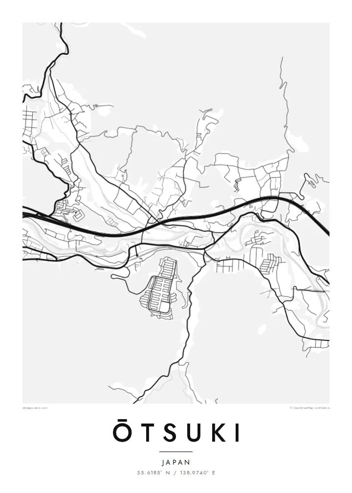
The river winds through the narrow valley, and almost every road and railway follows it. That creates the long, bundled shape at the centre of the map.
ቀላል ንድፍ ያለው የካርታ ፖስተር · ጃፓን
35.6185° N / 138.9740° E
A narrow mountain valley town where river, railway and expressway squeeze together below steep forested slopes


አንድ ከተማ፣ አምስት ስሜቶች
ዘይቤ በመንካት በግድግዳ ላይ ይመልከቱት። ሁሉም ዘይቤዎች ተመሳሳይ ዋጋ አላቸው — የታተመ፣ በፍሬም የተደረገ ወይም እንደ HD ፋይል።
 ትክክለኛ ፒክሰሎች · 24 × 36″ የህትመት ፋይል
ለህትመት ጥርት ያለ
ይህ ከትክክለኛው የህትመት ፋይል 100% የተቆረጠ ክፍል ነው። እያንዳንዱ ፖስተር — የታተመ፣ በፍሬም የተደረገ ወይም የወረደ — በእኛ አገልጋዮች ላይ በ300 DPI፣ እስከ 7,200 × 10,800 ፒክሰሎች ይሠራል፣ ስለዚህ በ24 × 36″ ህትመት ላይ እንኳን ትንንሾቹ መንገዶች ግልጽ ሆነው ይቆያሉ።
በግድግዳ ላይ


ካርታው
Ōtsuki lies in eastern Yamanashi, in a deep valley surrounded by steep, wooded mountains. From above the town is long and narrow. The Katsura River, the JR Chūō Main Line and the Chūō Expressway all follow the valley floor, with homes and small streets fitted into whatever flat land remains between them.
Ōtsuki is a junction on the route to Mount Fuji. The Fujikyū line branches south from Ōtsuki Station toward Fujiyoshida and Kawaguchiko, so many travellers change trains here. Just east of the centre is the Saruhashi, the Monkey Bridge, a wooden cantilever bridge over a gorge, often counted among Japan's three unusual bridges.
An Ōtsuki map poster shows the town squeezed into its setting. The river and transport lines form strong parallel curves, and the mountains appear as broad empty areas crossed by only a few winding roads. It is a clear record of how a Japanese valley town is shaped by its terrain, and it suits both residents and Fuji travellers.
The river winds through the narrow valley, and almost every road and railway follows it. That creates the long, bundled shape at the centre of the map.
The Monkey Bridge spans a narrow gorge east of the centre. This wooden cantilever bridge is one of the best-known historic structures in the region.
At Ōtsuki Station the Fujikyū line leaves the Chūō Main Line and heads south toward Mount Fuji, giving the map a branching rail line.
የራስዎ ያድርጉት
ቀን፣ ስም ወይም የራስዎን ጽሑፍ ያክሉ፤ ስታይልን፣ መጠንን ወይም አቅጣጫን ይቀይሩ።
ነፃው ቅድመ-እይታ ዝቅተኛ ጥራት ያለው እና የውሃ ምልክት ያለበት ነው። ህትመቶች እና HD ፋይሎች በ300 DPI፣ እስከ 7,200 × 10,800 px፣ ያለ ውሃ ምልክት ይሠራሉ።
ለምን Ōtsuki
Many people pass through Ōtsuki on the way to Fuji, and some stay long enough to know its valley well. The map captures that transit role and the dramatic setting, and the empty mountain areas make it a very graphic print.
Change the title and subtitle, including Japanese text if you prefer, and add a date or adjust the coordinates line. The five styles are Classic black and white, Noir, Paper, Blueprint and Sand. Noir works well with the narrow valley.
የŌtsuki ፖስተር ይዘዙ| የህትመት መጠን | ጥራት | ፋይሎች |
|---|---|---|
| 30 × 40 cm (11.8 × 15.7″) | 3,543 × 4,724 px | PNG · PDF |
| 29.7 × 42 cm (A3, 11.7 × 16.5″) | 3,508 × 4,961 px | PNG · PDF |
| 42 × 59.4 cm (A2, 16.5 × 23.4″) | 4,961 × 7,016 px | PNG · PDF |
| 45.7 × 61 cm (18 × 24″) | 5,400 × 7,200 px | PNG · PDF |
| 50 × 70 cm (19.7 × 27.6″) | 5,906 × 8,268 px | PNG · PDF |
| 61 × 91.4 cm (24 × 36″) | 7,200 × 10,800 px | PNG · PDF |
ለማነጻጸር፣ ነፃው ቅድመ እይታ 900 px ስፋት ያለው፣ የውሃ ምልክት ያለበት እና ለስክሪን የታሰበ ነው። HD ፋይሎቹ በእያንዳንዱ አቅጣጫ እስከ 8 እጥፍ ጥራት አላቸው፤ በሙሉ የፖስተር መጠንም በንጽህና ይታተማሉ።
በገጹ የላይኛው ክፍል ላይ ዘይቤ ይምረጡ፣ ከዚያም የታተመ ፖስተር — መጠን እና ካስፈለገ ፍሬም — ወይም ዲጂታል HD ፋይሎችን ይምረጡ። ክፍያው በአንድ ደረጃ ይጠናቀቃል፣ ክፍያው እንደተጠናቀቀ የትዕዛዝ ገጽዎ ወዲያውኑ ይዘምናል።
በስድስት መጠኖች ውስጥ በአንዱ፣ ከ30 × 40 ሴ.ሜ እስከ 24 × 36″ ባለ ከፍተኛ ጥራት 200 gsm ማት ወረቀት ላይ ይታተማል። የታተሙ ፖስተሮች ከ{printFrom} ጀምሮ ናቸው፣ ማጓጓዣን ጨምሮ።
አዎ። ጠንካራ የእንጨት ፍሬም በጥቁር፣ በነጭ፣ በተፈጥሯዊ ኦክ ወይም በጥቁር እንጨት ይምረጡ። የማይሰበር መስታወት ያለው ሲሆን ወዲያውኑ ለመስቀል ዝግጁ ነው። በፍሬም የተደረጉ ፖስተሮች ከ{framedFrom} ጀምሮ ናቸው፣ ማጓጓዣን ጨምሮ።
ማጓጓዣ በመላው ዓለም ነፃ ነው። እያንዳንዱ ፖስተር ከ30+ አገሮች ውስጥ በሚገኙ የሕትመት አጋሮቻችን መካከል ለእርስዎ በጣም ቅርብ በሆነው ይታተማል፤ አብዛኛውን ጊዜ በ3–7 የሥራ ቀናት ውስጥ ይደርሳል። ሁኔታውንና የመከታተያ መረጃውን በ«ትዕዛዞቼ» ውስጥ ማየት ይችላሉ። ጥቂት አገሮች ከ2–5 ሳምንታት ይወስዳሉ፤ እስካሁን በማንልክባቸው አገሮች ደግሞ ከመክፈልዎ በፊት ድረ ገጹ ያሳውቅዎታል።
በደረሰ በ14 ቀናት ውስጥ ፎቶ ይላኩልን፣ በነፃ እንደግመዋለን ወይም ገንዘብዎን እንመልሳለን።
አዎ። በዚህ ገጽ ላይ ባለው አርታኢ ውስጥ፣ ርዕሱን፣ ንዑስ ርዕሱን እና የመጋጠሚያ መስመሩን እንደፈለጉት ይቀይሩ፣ ዘይቤ እና መጠን ይምረጡ። የታተሙ፣ በፍሬም የተደረጉ እና ዲጂታል ትዕዛዞች ሁሉም የእርስዎን ንድፍ በትክክል ይጠቀማሉ።
በ$9 በ300 DPI PNG እና ለህትመት ዝግጁ የሆኑ PDF ፋይሎችን በሁሉም ስድስት መጠኖች፣ ያለ ውሃ ምልክት፣ በየትኛውም ቦታ ለማተም ያገኛሉ። እርግጠኛ ካልሆኑ? መጀመሪያ ነፃ የውሃ ምልክት ያለበት ቅድመ-እይታ ያውርዱ።
