Lagoons and bays
Shallow bays and enclosed lagoons break the coastline in many places. They create a sequence of curved inlets that gives the island a detailed, irregular edge.
ቀላል ንድፍ ያለው የካርታ ፖስተር · ኢንዶኔዢያ
10.6870° S / 123.1155° E
A long, low island just southwest of Timor, its coast scalloped by bays and fringed with lagoons and small islets.




አንድ ከተማ፣ አምስት ስሜቶች
ዘይቤ በመንካት በግድግዳ ላይ ይመልከቱት። ሁሉም ዘይቤዎች ተመሳሳይ ዋጋ አላቸው — የታተመ፣ በፍሬም የተደረገ ወይም እንደ HD ፋይል።
 ትክክለኛ ፒክሰሎች · 24 × 36″ የህትመት ፋይል
ለህትመት ጥርት ያለ
ይህ ከትክክለኛው የህትመት ፋይል 100% የተቆረጠ ክፍል ነው። እያንዳንዱ ፖስተር — የታተመ፣ በፍሬም የተደረገ ወይም የወረደ — በእኛ አገልጋዮች ላይ በ300 DPI፣ እስከ 7,200 × 10,800 ፒክሰሎች ይሠራል፣ ስለዚህ በ24 × 36″ ህትመት ላይ እንኳን ትንንሾቹ መንገዶች ግልጽ ሆነው ይቆያሉ።
በግድግዳ ላይ


ካርታው
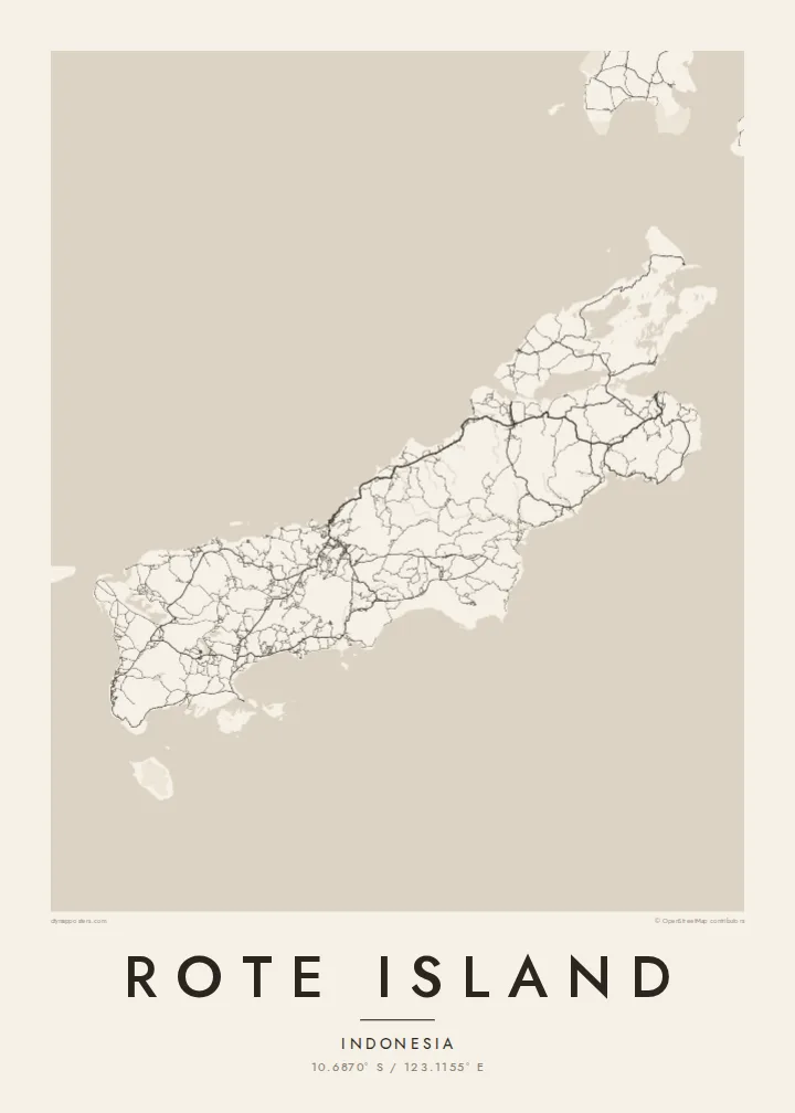
Rote, also written Roti, lies off the southwestern tip of Timor in East Nusa Tenggara, near the southern edge of the Indonesian archipelago. It is long and fairly low, stretched roughly from northeast to southwest, with a coastline broken by shallow bays, lagoons and reefs. Smaller islands are scattered around it, especially off the southwestern end.
Much of the island is dry savanna, and the lontar palm has long been central to local life. Its sap is tapped for sugar and drink, and its leaves are used for weaving. The island is also associated with the sasando, a stringed instrument with a resonator made from a lontar leaf. On the southwest coast, Nemberala has become known for its surf.
A Rote Island map poster follows the island's long axis, with a road network that links villages across the dry interior and down to the coast. The main town, Ba'a, sits on the northern side facing Timor, while the bays and lagoons of the southern and western shores give the outline a rich, uneven texture.
Shallow bays and enclosed lagoons break the coastline in many places. They create a sequence of curved inlets that gives the island a detailed, irregular edge.
The main town lies on the northern side of the island and looks across the sea toward Timor. Its streets form the densest cluster of lines on the map.
Off the southwestern end, a scattering of small islands trails into the sea. They include Ndana, often described as the southernmost island of Indonesia.
የራስዎ ያድርጉት
ቀን፣ ስም ወይም የራስዎን ጽሑፍ ያክሉ፤ ስታይልን፣ መጠንን ወይም አቅጣጫን ይቀይሩ።
ነፃው ቅድመ-እይታ ዝቅተኛ ጥራት ያለው እና የውሃ ምልክት ያለበት ነው። ህትመቶች እና HD ፋይሎች በ300 DPI፣ እስከ 7,200 × 10,800 px፣ ያለ ውሃ ምልክት ይሠራሉ።
ለምን Rote Island
Rote is remembered by surfers who spent weeks waiting for waves at Nemberala and by families whose roots are in its villages. A map poster draws the whole island, from the road to Ba'a to the islets in the far southwest, and gives those memories a quiet, lasting form.
Choose any wording for the title and subtitle, such as a village, a surf break or a date, and edit the coordinates line to match. Classic black & white, Noir, Paper, Blueprint and Sand are all available. The $9 HD set includes six sizes, and there is a free watermarked preview.
የRote Island ፖስተር ይዘዙ| የህትመት መጠን | ጥራት | ፋይሎች |
|---|---|---|
| 30 × 40 cm11.8 × 15.7″ | 3,543 × 4,724 px | PNG · PDF |
| 29.7 × 42 cm (A3)11.7 × 16.5″ | 3,508 × 4,961 px | PNG · PDF |
| 42 × 59.4 cm (A2)16.5 × 23.4″ | 4,961 × 7,016 px | PNG · PDF |
| 45.7 × 61 cm18 × 24″ | 5,400 × 7,200 px | PNG · PDF |
| 50 × 70 cm19.7 × 27.6″ | 5,906 × 8,268 px | PNG · PDF |
| 61 × 91.4 cm24 × 36″ | 7,200 × 10,800 px | PNG · PDF |
ለማነጻጸር፣ ነፃው ቅድመ እይታ 900 px ስፋት ያለው፣ የውሃ ምልክት ያለበት እና ለስክሪን የታሰበ ነው። HD ፋይሎቹ በእያንዳንዱ አቅጣጫ እስከ 8 እጥፍ ጥራት አላቸው፤ በሙሉ የፖስተር መጠንም በንጽህና ይታተማሉ።
በገጹ የላይኛው ክፍል ላይ ዘይቤ ይምረጡ፣ ከዚያም የታተመ ፖስተር — መጠን እና ካስፈለገ ፍሬም — ወይም ዲጂታል HD ፋይሎችን ይምረጡ። ክፍያው በአንድ ደረጃ ይጠናቀቃል፣ ክፍያው እንደተጠናቀቀ የትዕዛዝ ገጽዎ ወዲያውኑ ይዘምናል።
በስድስት መጠኖች ውስጥ በአንዱ፣ ከ30 × 40 ሴ.ሜ እስከ 24 × 36″ ባለ ከፍተኛ ጥራት 200 gsm ማት ወረቀት ላይ ይታተማል። የታተሙ ፖስተሮች ከ$39 ጀምሮ ናቸው፣ ማጓጓዣን ጨምሮ።
አዎ። ጠንካራ የእንጨት ፍሬም በጥቁር፣ በነጭ፣ በተፈጥሯዊ ኦክ ወይም በጥቁር እንጨት ይምረጡ። የማይሰበር መስታወት ያለው ሲሆን ወዲያውኑ ለመስቀል ዝግጁ ነው። በፍሬም የተደረጉ ፖስተሮች ከ$99 ጀምሮ ናቸው፣ ማጓጓዣን ጨምሮ።
ወደ 60+ አገሮች መላኪያ ነፃ ነው። እያንዳንዱ ፖስተር በ30+ አገሮች ካሉ የህትመት አጋሮቻችን በአቅራቢያዎ ባለው ይታተማል፤ አብዛኛውን ጊዜ በ3–7 የሥራ ቀናት ውስጥ ይደርሳል። ሁኔታውንና መከታተያውን በ«የእኔ ትዕዛዞች» ውስጥ ማየት ይችላሉ። ጥቂት አገሮች ከ2–5 ሳምንታት ይወስዳሉ፤ እስካሁን በማንልክበት አገር ደግሞ ከመክፈልዎ በፊት ድረ-ገጹ ያሳውቅዎታል።
በደረሰ በ14 ቀናት ውስጥ ፎቶ ይላኩልን፣ በነፃ እንደግመዋለን ወይም ገንዘብዎን እንመልሳለን።
አዎ። በዚህ ገጽ ላይ ባለው አርታኢ ውስጥ፣ ርዕሱን፣ ንዑስ ርዕሱን እና የመጋጠሚያ መስመሩን እንደፈለጉት ይቀይሩ፣ ዘይቤ እና መጠን ይምረጡ። የታተሙ፣ በፍሬም የተደረጉ እና ዲጂታል ትዕዛዞች ሁሉም የእርስዎን ንድፍ በትክክል ይጠቀማሉ።
በ$9 በ300 DPI PNG እና ለህትመት ዝግጁ የሆኑ PDF ፋይሎችን በሁሉም ስድስት መጠኖች፣ ያለ ውሃ ምልክት፣ በየትኛውም ቦታ ለማተም ያገኛሉ። እርግጠኛ ካልሆኑ? መጀመሪያ ነፃ የውሃ ምልክት ያለበት ቅድመ-እይታ ያውርዱ።
