Ajinkyatara fort hill
The fort's plateau rises right beside the town. On the map the streets thin out and bend around its slopes, leaving a clear open shape that anchors the whole composition.
ቀላል ንድፍ ያለው የካርታ ፖስተር · ህንድ
17.6859° N / 73.9933° E
A hill-ringed Deccan town between the Krishna and Venna rivers, with a fort ridge rising directly above its streets


አንድ ከተማ፣ አምስት ስሜቶች
ዘይቤ በመንካት በግድግዳ ላይ ይመልከቱት። ሁሉም ዘይቤዎች ተመሳሳይ ዋጋ አላቸው — የታተመ፣ በፍሬም የተደረገ ወይም እንደ HD ፋይል።
 ትክክለኛ ፒክሰሎች · 24 × 36″ የህትመት ፋይል
ለህትመት ጥርት ያለ
ይህ ከትክክለኛው የህትመት ፋይል 100% የተቆረጠ ክፍል ነው። እያንዳንዱ ፖስተር — የታተመ፣ በፍሬም የተደረገ ወይም የወረደ — በእኛ አገልጋዮች ላይ በ300 DPI፣ እስከ 7,200 × 10,800 ፒክሰሎች ይሠራል፣ ስለዚህ በ24 × 36″ ህትመት ላይ እንኳን ትንንሾቹ መንገዶች ግልጽ ሆነው ይቆያሉ።
በግድግዳ ላይ


ካርታው
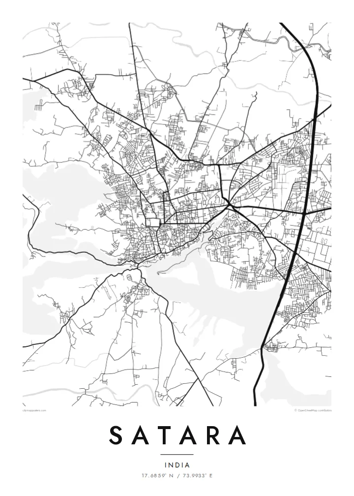
Satara sits in a bowl of the Western Ghats foothills, close to where the Venna joins the Krishna. From above, the town spreads across fairly level ground and stops where the slopes begin, so the edges of its street network follow the contours of the hills around it. Ajinkyatara, the fort that overlooks the city, shows on the map as a flat-topped ridge pressing against the edge of town.
Satara matters in Maratha history. In the eighteenth century it was the seat of the Chhatrapati line descended from Shivaji. The older quarters still have the dense, irregular lanes of a courtly town rather than a planned grid. Newer neighbourhoods and the main highway corridor spread outward in straighter lines, so the map has two distinct textures side by side.
A Satara map poster also has room for the landscape beyond the town. To the west, the Kaas plateau, known for the wildflowers that cover it after the monsoon, sits high on the escarpment, and roads climb toward it in tight switchbacks. Drawn in fine black lines, the river, the fort hill and the winding ghat roads make a composition that is clearly tied to its terrain.
The fort's plateau rises right beside the town. On the map the streets thin out and bend around its slopes, leaving a clear open shape that anchors the whole composition.
Two rivers meet near the city. Their curving channels add soft, organic lines to the map, a counterpoint to the compact and busy street pattern of the town itself.
Roads heading west toward the Sahyadri escarpment fold into tight hairpins as they climb, a pattern that reads almost like handwriting when printed in thin black line.
የራስዎ ያድርጉት
ቀን፣ ስም ወይም የራስዎን ጽሑፍ ያክሉ፤ ስታይልን፣ መጠንን ወይም አቅጣጫን ይቀይሩ።
ነፃው ቅድመ-እይታ ዝቅተኛ ጥራት ያለው እና የውሃ ምልክት ያለበት ነው። ህትመቶች እና HD ፋይሎች በ300 DPI፣ እስከ 7,200 × 10,800 px፣ ያለ ውሃ ምልክት ይሠራሉ።
ለምን Satara
For people from Satara, and for those who have passed through on the way to the Kaas plateau or Mahabaleshwar, this map shows a familiar geography of fort, river and hills. It works as a quiet reminder of home, of student years, or of a monsoon trek.
You can set your own title, subtitle and coordinates line, adding a family name or a date, and choose from five styles: Classic black & white, Noir, Paper, Blueprint or Sand. You can download HD files for $9 or order a matte print with an optional wooden frame.
የSatara ፖስተር ይዘዙ| የህትመት መጠን | ጥራት | ፋይሎች |
|---|---|---|
| 30 × 40 cm (11.8 × 15.7″) | 3,543 × 4,724 px | PNG · PDF |
| 29.7 × 42 cm (A3, 11.7 × 16.5″) | 3,508 × 4,961 px | PNG · PDF |
| 42 × 59.4 cm (A2, 16.5 × 23.4″) | 4,961 × 7,016 px | PNG · PDF |
| 45.7 × 61 cm (18 × 24″) | 5,400 × 7,200 px | PNG · PDF |
| 50 × 70 cm (19.7 × 27.6″) | 5,906 × 8,268 px | PNG · PDF |
| 61 × 91.4 cm (24 × 36″) | 7,200 × 10,800 px | PNG · PDF |
ለማነጻጸር፣ ነፃው ቅድመ እይታ 900 px ስፋት ያለው፣ የውሃ ምልክት ያለበት እና ለስክሪን የታሰበ ነው። HD ፋይሎቹ በእያንዳንዱ አቅጣጫ እስከ 8 እጥፍ ጥራት አላቸው፤ በሙሉ የፖስተር መጠንም በንጽህና ይታተማሉ።
በገጹ የላይኛው ክፍል ላይ ዘይቤ ይምረጡ፣ ከዚያም የታተመ ፖስተር — መጠን እና ካስፈለገ ፍሬም — ወይም ዲጂታል HD ፋይሎችን ይምረጡ። ክፍያው በአንድ ደረጃ ይጠናቀቃል፣ ክፍያው እንደተጠናቀቀ የትዕዛዝ ገጽዎ ወዲያውኑ ይዘምናል።
በስድስት መጠኖች ውስጥ በአንዱ፣ ከ30 × 40 ሴ.ሜ እስከ 24 × 36″ ባለ ከፍተኛ ጥራት 200 gsm ማት ወረቀት ላይ ይታተማል። የታተሙ ፖስተሮች ከ$39 ጀምሮ ናቸው፣ ማጓጓዣን ጨምሮ።
አዎ። ጠንካራ የእንጨት ፍሬም በጥቁር፣ በነጭ፣ በተፈጥሯዊ ኦክ ወይም በጥቁር እንጨት ይምረጡ። የማይሰበር መስታወት ያለው ሲሆን ወዲያውኑ ለመስቀል ዝግጁ ነው። በፍሬም የተደረጉ ፖስተሮች ከ$99 ጀምሮ ናቸው፣ ማጓጓዣን ጨምሮ።
ማጓጓዣ በመላው ዓለም ነፃ ነው። እያንዳንዱ ፖስተር ከ30+ አገሮች ውስጥ በሚገኙ የሕትመት አጋሮቻችን መካከል ለእርስዎ በጣም ቅርብ በሆነው ይታተማል፤ አብዛኛውን ጊዜ በ3–7 የሥራ ቀናት ውስጥ ይደርሳል። ሁኔታውንና የመከታተያ መረጃውን በ«ትዕዛዞቼ» ውስጥ ማየት ይችላሉ። ጥቂት አገሮች ከ2–5 ሳምንታት ይወስዳሉ፤ እስካሁን በማንልክባቸው አገሮች ደግሞ ከመክፈልዎ በፊት ድረ ገጹ ያሳውቅዎታል።
በደረሰ በ14 ቀናት ውስጥ ፎቶ ይላኩልን፣ በነፃ እንደግመዋለን ወይም ገንዘብዎን እንመልሳለን።
አዎ። በዚህ ገጽ ላይ ባለው አርታኢ ውስጥ፣ ርዕሱን፣ ንዑስ ርዕሱን እና የመጋጠሚያ መስመሩን እንደፈለጉት ይቀይሩ፣ ዘይቤ እና መጠን ይምረጡ። የታተሙ፣ በፍሬም የተደረጉ እና ዲጂታል ትዕዛዞች ሁሉም የእርስዎን ንድፍ በትክክል ይጠቀማሉ።
በ$9 በ300 DPI PNG እና ለህትመት ዝግጁ የሆኑ PDF ፋይሎችን በሁሉም ስድስት መጠኖች፣ ያለ ውሃ ምልክት፣ በየትኛውም ቦታ ለማተም ያገኛሉ። እርግጠኛ ካልሆኑ? መጀመሪያ ነፃ የውሃ ምልክት ያለበት ቅድመ-እይታ ያውርዱ።
