Firebreak esplanades
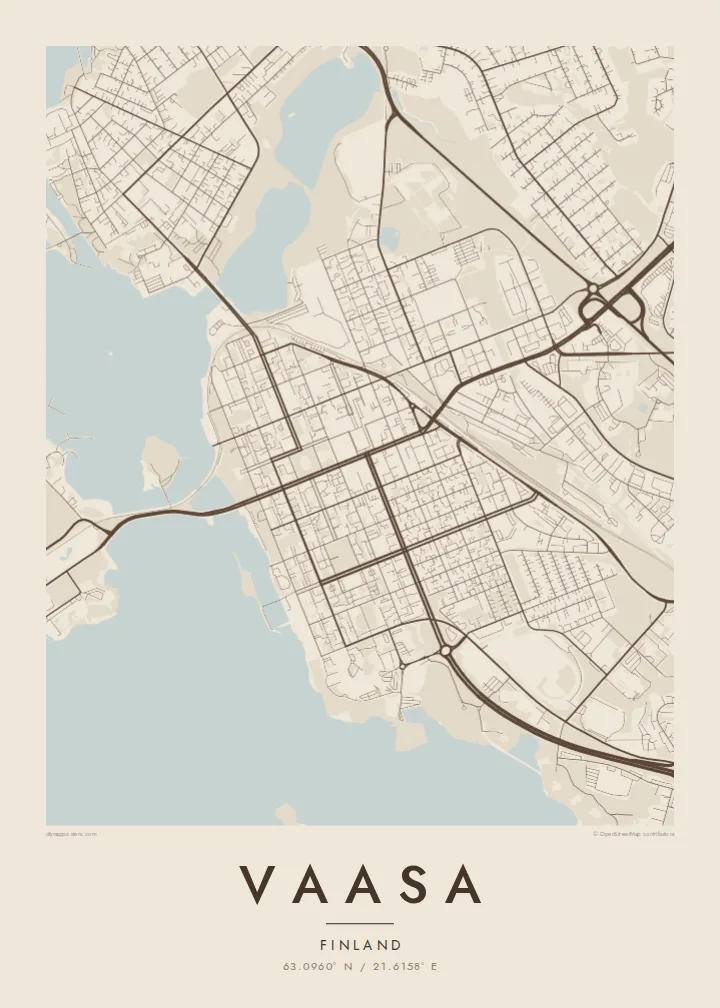
The wide boulevards laid out after the 1852 fire cross the centre in long, open strips, giving the map a strong framework of broad avenues and regular blocks.
ቀላል ንድፍ ያለው የካርታ ፖስተር · ፊንላንድ
63.0960° N / 21.6158° E
Wide esplanades on a planned grid by the Gulf of Bothnia, fraying into the islands of the rising Kvarken archipelago.


አንድ ከተማ፣ አምስት ስሜቶች
ዘይቤ በመንካት በግድግዳ ላይ ይመልከቱት። ሁሉም ዘይቤዎች ተመሳሳይ ዋጋ አላቸው — የታተመ፣ በፍሬም የተደረገ ወይም እንደ HD ፋይል።
 ትክክለኛ ፒክሰሎች · 24 × 36″ የህትመት ፋይል
ለህትመት ጥርት ያለ
ይህ ከትክክለኛው የህትመት ፋይል 100% የተቆረጠ ክፍል ነው። እያንዳንዱ ፖስተር — የታተመ፣ በፍሬም የተደረገ ወይም የወረደ — በእኛ አገልጋዮች ላይ በ300 DPI፣ እስከ 7,200 × 10,800 ፒክሰሎች ይሠራል፣ ስለዚህ በ24 × 36″ ህትመት ላይ እንኳን ትንንሾቹ መንገዶች ግልጽ ሆነው ይቆያሉ።
በግድግዳ ላይ


ካርታው
Vaasa, known in Swedish as Vasa, sits on Finland's west coast facing the Kvarken, the narrow part of the Gulf of Bothnia between Finland and Sweden. After the old town burned in 1852, the city was rebuilt several kilometres closer to the sea on a new plan. Broad tree-lined esplanades were laid out as firebreaks, and on a map they divide the centre into a clean, generous grid.
Around this planned core, the coastline breaks into bays, peninsulas and countless islands. The Kvarken archipelago is a UNESCO World Heritage Site, recognised for its rapid land uplift, as the ground continues to rise after the last Ice Age and new land emerges from the sea. The Replot Bridge, the longest in Finland, links the mainland to the island of Replot.
The city briefly served as the seat of Finland's government during the civil war of 1918, a period still remembered in its history. A Vaasa map poster combines two distinct characters: the precise, orderly grid of a nineteenth-century city and the fragmented, slowly changing shoreline beyond it. The contrast gives the print unusual depth.
The wide boulevards laid out after the 1852 fire cross the centre in long, open strips, giving the map a strong framework of broad avenues and regular blocks.
Hundreds of islands and skerries scatter across the sea to the west, part of a UNESCO site where post-glacial uplift slowly adds new land every year.
Finland's longest bridge carries the road from the mainland out to Replot island, drawing a single straight line across open water in the archipelago.
የራስዎ ያድርጉት
ቀን፣ ስም ወይም የራስዎን ጽሑፍ ያክሉ፤ ስታይልን፣ መጠንን ወይም አቅጣጫን ይቀይሩ።
ነፃው ቅድመ-እይታ ዝቅተኛ ጥራት ያለው እና የውሃ ምልክት ያለበት ነው። ህትመቶች እና HD ፋይሎች በ300 DPI፣ እስከ 7,200 × 10,800 px፣ ያለ ውሃ ምልክት ይሠራሉ።
ለምን Vaasa
Vaasa draws people through its two language communities, its universities and its energy industry, and many who leave keep a strong attachment to the coast. A map of the city balances street plan and seascape, which makes it a natural fit above a desk or in a hallway.
Set your own title, add a subtitle or a date, and keep or edit the coordinates line. Choose from Classic black & white, Noir, Paper, Blueprint or Sand. The $9 digital download covers six print sizes, and printed posters come on matte paper.
የVaasa ፖስተር ይዘዙ| የህትመት መጠን | ጥራት | ፋይሎች |
|---|---|---|
| 30 × 40 cm (11.8 × 15.7″) | 3,543 × 4,724 px | PNG · PDF |
| 29.7 × 42 cm (A3, 11.7 × 16.5″) | 3,508 × 4,961 px | PNG · PDF |
| 42 × 59.4 cm (A2, 16.5 × 23.4″) | 4,961 × 7,016 px | PNG · PDF |
| 45.7 × 61 cm (18 × 24″) | 5,400 × 7,200 px | PNG · PDF |
| 50 × 70 cm (19.7 × 27.6″) | 5,906 × 8,268 px | PNG · PDF |
| 61 × 91.4 cm (24 × 36″) | 7,200 × 10,800 px | PNG · PDF |
ለማነጻጸር፣ ነፃው ቅድመ እይታ 900 px ስፋት ያለው፣ የውሃ ምልክት ያለበት እና ለስክሪን የታሰበ ነው። HD ፋይሎቹ በእያንዳንዱ አቅጣጫ እስከ 8 እጥፍ ጥራት አላቸው፤ በሙሉ የፖስተር መጠንም በንጽህና ይታተማሉ።
በገጹ የላይኛው ክፍል ላይ ዘይቤ ይምረጡ፣ ከዚያም የታተመ ፖስተር — መጠን እና ካስፈለገ ፍሬም — ወይም ዲጂታል HD ፋይሎችን ይምረጡ። ክፍያው በአንድ ደረጃ ይጠናቀቃል፣ ክፍያው እንደተጠናቀቀ የትዕዛዝ ገጽዎ ወዲያውኑ ይዘምናል።
በስድስት መጠኖች ውስጥ በአንዱ፣ ከ30 × 40 ሴ.ሜ እስከ 24 × 36″ ባለ ከፍተኛ ጥራት 200 gsm ማት ወረቀት ላይ ይታተማል። የታተሙ ፖስተሮች ከ$39 ጀምሮ ናቸው፣ ማጓጓዣን ጨምሮ።
አዎ። ጠንካራ የእንጨት ፍሬም በጥቁር፣ በነጭ፣ በተፈጥሯዊ ኦክ ወይም በጥቁር እንጨት ይምረጡ። የማይሰበር መስታወት ያለው ሲሆን ወዲያውኑ ለመስቀል ዝግጁ ነው። በፍሬም የተደረጉ ፖስተሮች ከ$99 ጀምሮ ናቸው፣ ማጓጓዣን ጨምሮ።
ማጓጓዣ በመላው ዓለም ነፃ ነው። እያንዳንዱ ፖስተር ከ30+ አገሮች ውስጥ በሚገኙ የሕትመት አጋሮቻችን መካከል ለእርስዎ በጣም ቅርብ በሆነው ይታተማል፤ አብዛኛውን ጊዜ በ3–7 የሥራ ቀናት ውስጥ ይደርሳል። ሁኔታውንና የመከታተያ መረጃውን በ«ትዕዛዞቼ» ውስጥ ማየት ይችላሉ። ጥቂት አገሮች ከ2–5 ሳምንታት ይወስዳሉ፤ እስካሁን በማንልክባቸው አገሮች ደግሞ ከመክፈልዎ በፊት ድረ ገጹ ያሳውቅዎታል።
በደረሰ በ14 ቀናት ውስጥ ፎቶ ይላኩልን፣ በነፃ እንደግመዋለን ወይም ገንዘብዎን እንመልሳለን።
አዎ። በዚህ ገጽ ላይ ባለው አርታኢ ውስጥ፣ ርዕሱን፣ ንዑስ ርዕሱን እና የመጋጠሚያ መስመሩን እንደፈለጉት ይቀይሩ፣ ዘይቤ እና መጠን ይምረጡ። የታተሙ፣ በፍሬም የተደረጉ እና ዲጂታል ትዕዛዞች ሁሉም የእርስዎን ንድፍ በትክክል ይጠቀማሉ።
በ$9 በ300 DPI PNG እና ለህትመት ዝግጁ የሆኑ PDF ፋይሎችን በሁሉም ስድስት መጠኖች፣ ያለ ውሃ ምልክት፣ በየትኛውም ቦታ ለማተም ያገኛሉ። እርግጠኛ ካልሆኑ? መጀመሪያ ነፃ የውሃ ምልክት ያለበት ቅድመ-እይታ ያውርዱ።
