Central junction
The main roads come together at the town centre, where the street network is densest. Most of the other routes on the poster branch out from this point.
Minimalist xəritə posteri · Uqanda
0.1340° S / 30.4962° E
A hill town in western Uganda, where roads follow the ridges and farmland fills the valleys between them


Bir şəhər, beş əhval
Divarda necə görünəcəyinə baxmaq üçün üzərinə toxunun. Bütün üslublar eyni qiymətə başa gəlir — çap, çərçivəli və ya HD fayl formasında.
 Əsl piksellər · 24 × 36″ çap faylı
Çapda kəskin
Bu, əsl çap faylının 100% böyüdülmüş hissəsidir. Hər poster — çap olunmuş, çərçivəli və ya endirilmiş — serverlərimizdə 300 DPI, 7,200 × 10,800 pikselə qədər keyfiyyətlə hazırlanır, ona görə 24 × 36″ çapda ən nazik yollar belə aydın qalır.
Divarda


Xəritə
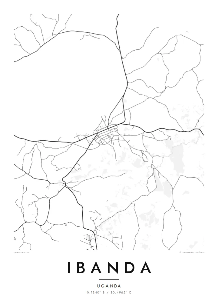
Ibanda is in western Uganda, in hilly country north of Mbarara. On a map the town looks loose and organic. There is a small commercial core where the main roads meet, and from there tracks and streets spread out along the ridges and down into the valleys. The land around is broken up by farm plots, so the edge of the built-up area is soft and hard to pin down.
The terrain shapes almost everything. Roads tend to follow contours rather than a grid, and housing gathers along the routes that link the town to nearby trading centres. Between the ridges, the lower ground is mostly cultivated. This region of Uganda is known for bananas and cattle keeping, and the farmland can be seen right up to the outer streets.
An Ibanda map poster shows that relationship between settlement and land. The streets make a fine, branching network, closer together near the centre and thinning out towards the hills. It is not a formal plan, and the pattern it forms looks natural, a little like the veins of a leaf spreading out from one stem.
The main roads come together at the town centre, where the street network is densest. Most of the other routes on the poster branch out from this point.
Many roads run along the tops of the hills and follow the curves of the land. On the map they show up as long, gently bending lines instead of straight segments.
Cultivated land comes right up to the town, so the outer streets break up into scattered tracks. This gives the map a soft, feathered edge.
Özünüzə uyğunlaşdırın
Tarix, ad və ya öz sözlərinizi əlavə edin, üslubu, ölçünü və ya istiqaməti dəyişin.
Pulsuz önizləmə aşağı keyfiyyətli və filiqranlıdır. Çap və HD fayllar filiqransız, 300 DPI, 7,200 × 10,800 px-ə qədər keyfiyyətlə hazırlanır.
Niyə Ibanda
An Ibanda map is a personal thing to own. It suits someone who grew up there, has family in the hills around the town or once worked in western Uganda and wants a quiet reminder of the place on the wall.
You can set the title, subtitle and coordinates line yourself, and pick one of five styles: Classic black and white, Noir, Paper, Blueprint or Sand. There is a free watermarked preview. Full HD files cost $9, and printed posters are shipped from partners in more than 30 countries.
Ibanda posterini sifariş et| Çap ölçüsü | Ölçülülük | Fayllar |
|---|---|---|
| 30 × 40 cm (11.8 × 15.7″) | 3,543 × 4,724 px | PNG · PDF |
| 29.7 × 42 cm (A3, 11.7 × 16.5″) | 3,508 × 4,961 px | PNG · PDF |
| 42 × 59.4 cm (A2, 16.5 × 23.4″) | 4,961 × 7,016 px | PNG · PDF |
| 45.7 × 61 cm (18 × 24″) | 5,400 × 7,200 px | PNG · PDF |
| 50 × 70 cm (19.7 × 27.6″) | 5,906 × 8,268 px | PNG · PDF |
| 61 × 91.4 cm (24 × 36″) | 7,200 × 10,800 px | PNG · PDF |
Müqayisə üçün: pulsuz önizləmə 900 px enindədir, su nişanlıdır və ekranlar üçün nəzərdə tutulub. HD faylların ölçülülüyü hər istiqamətdə 8 dəfəyədək yüksəkdir və tam poster ölçüsündə təmiz çap olunur.
Səhifənin yuxarısından bir üslub seçin, sonra Çap Olunmuş Poster — ölçü və istəyə görə çərçivə — və ya Rəqəmsal HD Fayllar arasından seçim edin. Ödəniş bir addımdan ibarətdir, ödəniş keçən kimi sifariş səhifəniz yenilənir.
O, 200 qram mat kağız üzərində, 30 × 40 sm-dən 24 × 36″-ə qədər altı ölçüdən birində çap olunur. Çap posterlərin qiyməti {printFrom}-dan başlayır, çatdırılma daxildir.
Bəli. Qara, ağ, təbii palıd və ya tünd rəngli taxta çərçivə seçə bilərsiniz. Sındırılmaz şüşə ilə gəlir və asmağa hazırdır. Çərçivəli posterlərin qiyməti {framedFrom}-dan başlayır, çatdırılma daxildir.
Çatdırılma bütün dünyada pulsuzdur. Hər poster 30-dan çox ölkədə olan tərəfdaşlarımızdan ən yaxınında çap olunur və adətən 3–7 iş günü ərzində çatır. Statusu və izləmə nömrəsini Sifarişlərim bölməsində görə bilərsiniz.
Çatdırılmadan sonra 14 gün ərzində bizə şəkil göndərin, pulsuz yenidən çap edərik və ya pulunuzu geri qaytararıq.
Bəli. Bu səhifədəki redaktorda başlığı, alt başlığı və koordinat sətrini istədiyiniz kimi dəyişin, üslub və ölçü seçin. Çap, çərçivəli və rəqəmsal sifarişlərin hamısı məhz sizin dizaynınızla hazırlanır.
$9 qarşılığında, filiqransız, 300 DPI PNG və çapa hazır PDF fayllarını bütün altı ölçüdə, hər yerdə çap edə biləcəyiniz formada əldə edirsiniz. Hələ qərarsızsınız? Əvvəlcə pulsuz filiqranlı önizləməni endirin.
Yaxınlıqda
