Lake Senba
The lake forms a large, smooth oval on the southwest side of the centre. Its shores are lined with walking paths and connect directly to the green of Kairakuen.
Minimalist xəritə posteri · Yaponiya
36.3500° N / 140.4500° E
A castle town on a narrow plateau between a river and a lake, with a famous plum garden on its western edge.


Bir şəhər, beş əhval
Divarda necə görünəcəyinə baxmaq üçün üzərinə toxunun. Bütün üslublar eyni qiymətə başa gəlir — çap, çərçivəli və ya HD fayl formasında.
 Əsl piksellər · 24 × 36″ çap faylı
Çapda kəskin
Bu, əsl çap faylının 100% böyüdülmüş hissəsidir. Hər poster — çap olunmuş, çərçivəli və ya endirilmiş — serverlərimizdə 300 DPI, 7,200 × 10,800 pikselə qədər keyfiyyətlə hazırlanır, ona görə 24 × 36″ çapda ən nazik yollar belə aydın qalır.
Divarda


Xəritə
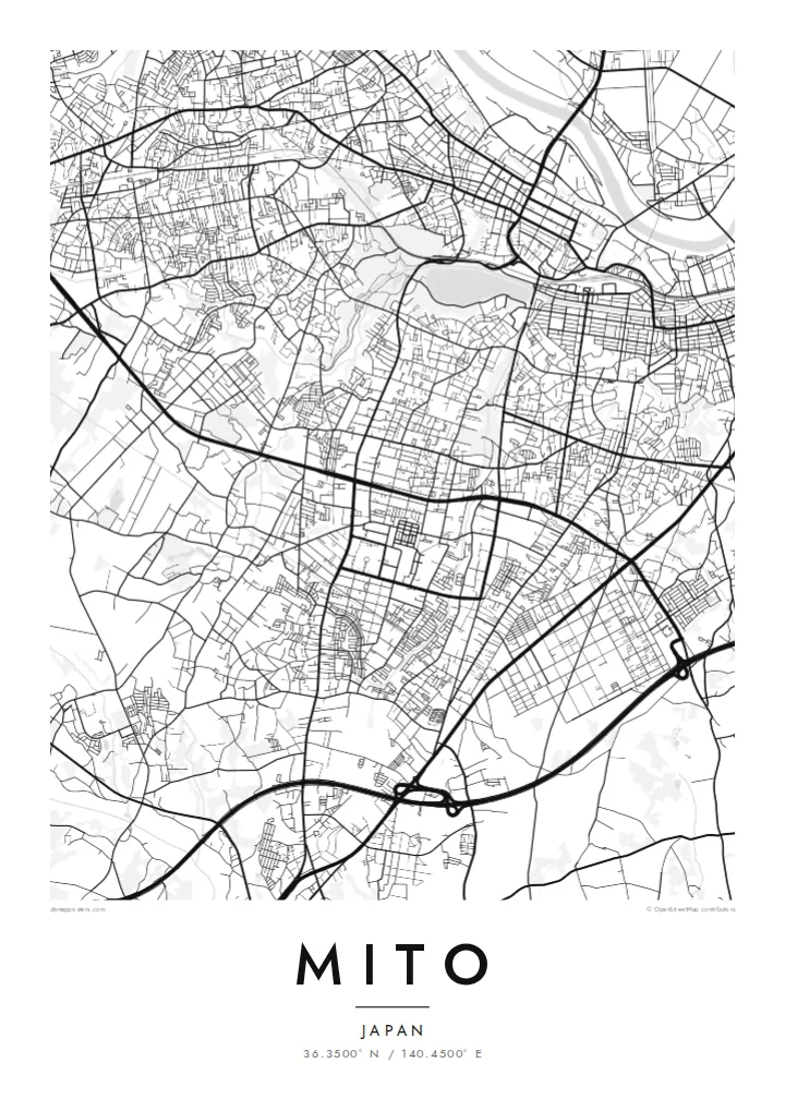
Mito, the capital of Ibaraki Prefecture, grew on a long, narrow plateau. The Naka River runs to the north and Lake Senba lies to the south and west. From above, that setting shapes the whole map. The old centre follows the ridge from east to west, with the river's floodplain on one side and the water and parkland of the lake on the other.
In the Edo period Mito was the seat of one of the three senior branches of the Tokugawa family. Its best-known landmark from that era is Kairakuen, a large garden created in the 1840s and counted among the three great gardens of Japan. It is especially famous for its thousands of plum trees, which bloom in late winter.
A Mito map poster shows the city's unusual long shape. The main streets run along the plateau, the rail lines follow the lowlands, and the broad oval of Lake Senba joins the green of Kairakuen to the west. Modern suburbs spread across the surrounding plains, but the old outline of the castle town is still easy to trace.
The lake forms a large, smooth oval on the southwest side of the centre. Its shores are lined with walking paths and connect directly to the green of Kairakuen.
The famous plum garden occupies a broad open area on the western edge of the old town, overlooking the lake. On the map it appears as a green gap in the streets.
The main streets of the historic centre run along a narrow ridge between river and lake. Together they give the city its long east–west form.
Özünüzə uyğunlaşdırın
Tarix, ad və ya öz sözlərinizi əlavə edin, üslubu, ölçünü və ya istiqaməti dəyişin.
Pulsuz önizləmə aşağı keyfiyyətli və filiqranlıdır. Çap və HD fayllar filiqransız, 300 DPI, 7,200 × 10,800 px-ə qədər keyfiyyətlə hazırlanır.
Niyə Mito
For people from Ibaraki and anyone who has seen the plum blossom at Kairakuen, this map records the city's defining shape. The lake, garden and plateau sit together in one balanced frame.
Personalise the title, subtitle and coordinates, perhaps with a season or year. Choose one of five styles: Classic black & white, Noir, Paper, Blueprint or Sand. Paper suits the garden-and-lake setting especially well.
Mito posterini sifariş et| Çap ölçüsü | Ölçülülük | Fayllar |
|---|---|---|
| 30 × 40 cm (11.8 × 15.7″) | 3,543 × 4,724 px | PNG · PDF |
| 29.7 × 42 cm (A3, 11.7 × 16.5″) | 3,508 × 4,961 px | PNG · PDF |
| 42 × 59.4 cm (A2, 16.5 × 23.4″) | 4,961 × 7,016 px | PNG · PDF |
| 45.7 × 61 cm (18 × 24″) | 5,400 × 7,200 px | PNG · PDF |
| 50 × 70 cm (19.7 × 27.6″) | 5,906 × 8,268 px | PNG · PDF |
| 61 × 91.4 cm (24 × 36″) | 7,200 × 10,800 px | PNG · PDF |
Müqayisə üçün: pulsuz önizləmə 900 px enindədir, su nişanlıdır və ekranlar üçün nəzərdə tutulub. HD faylların ölçülülüyü hər istiqamətdə 8 dəfəyədək yüksəkdir və tam poster ölçüsündə təmiz çap olunur.
Səhifənin yuxarısından bir üslub seçin, sonra Çap Olunmuş Poster — ölçü və istəyə görə çərçivə — və ya Rəqəmsal HD Fayllar arasından seçim edin. Ödəniş bir addımdan ibarətdir, ödəniş keçən kimi sifariş səhifəniz yenilənir.
O, 200 qram mat kağız üzərində, 30 × 40 sm-dən 24 × 36″-ə qədər altı ölçüdən birində çap olunur. Çap posterlərin qiyməti {printFrom}-dan başlayır, çatdırılma daxildir.
Bəli. Qara, ağ, təbii palıd və ya tünd rəngli taxta çərçivə seçə bilərsiniz. Sındırılmaz şüşə ilə gəlir və asmağa hazırdır. Çərçivəli posterlərin qiyməti {framedFrom}-dan başlayır, çatdırılma daxildir.
Çatdırılma bütün dünyada pulsuzdur. Hər poster 30-dan çox ölkədəki çap tərəfdaşlarımızdan ən yaxınında çap olunur və adətən 3–7 iş günü ərzində çatır. Statusu və izləmə nömrəsini «Sifarişlərim» bölməsində izləyə bilərsiniz. Bəzi ölkələrə çatdırılma 2–5 həftə çəkir, hələ çatdırmadığımız ölkələr barədə isə sayt ödənişdən əvvəl xəbər verir.
Çatdırılmadan sonra 14 gün ərzində bizə şəkil göndərin, pulsuz yenidən çap edərik və ya pulunuzu geri qaytararıq.
Bəli. Bu səhifədəki redaktorda başlığı, alt başlığı və koordinat sətrini istədiyiniz kimi dəyişin, üslub və ölçü seçin. Çap, çərçivəli və rəqəmsal sifarişlərin hamısı məhz sizin dizaynınızla hazırlanır.
$9 qarşılığında, filiqransız, 300 DPI PNG və çapa hazır PDF fayllarını bütün altı ölçüdə, hər yerdə çap edə biləcəyiniz formada əldə edirsiniz. Hələ qərarsızsınız? Əvvəlcə pulsuz filiqranlı önizləməni endirin.
Yaxınlıqda
