The Mahakali River
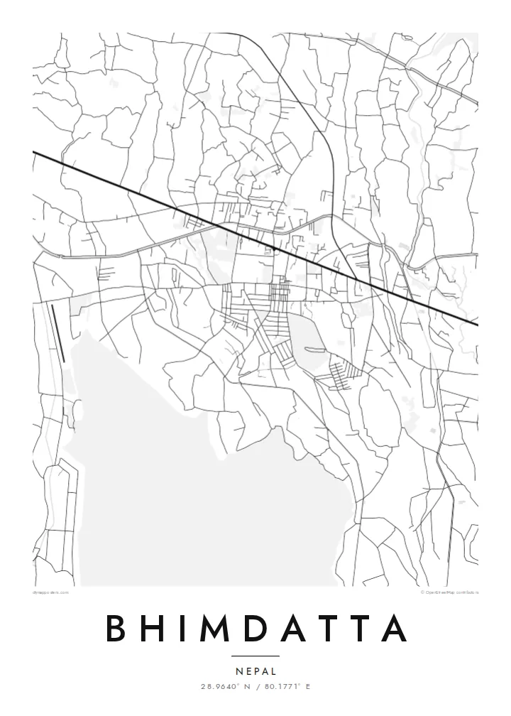
The broad braided river along the western edge forms the international border. Its channels and sandbars give the map a loose, shifting edge instead of a hard line.
Мінімалістычны постар з картай · Непал
28.9640° N / 80.1771° E
A flat Terai town at Nepal's far-western edge, set between the Mahakali River, forest reserves and the first ridges of hills.


Адзін горад — пяць настрояў
Дакраніцеся да стылю, каб убачыць яго на сцяне. Усе стылі каштуюць аднолькава — друкаваны варыянт, у раме або HD-файлы.
 Рэальныя пікселі · файл для друку 24 × 36″
Выразна ў друку
Гэта 100% фрагмент сапраўднага файла для друку. Кожны постар — надрукаваны, у раме або спампаваны — рэндэрыцца на нашых серверах пры 300 DPI, да 7,200 × 10,800 пікселяў, таму нават самыя дробныя вулачкі застаюцца выразнымі пры друку 24 × 36″.
На сцяне


Карта
Bhimdatta, long known as Mahendranagar, is the main town of Kanchanpur District in Sudurpashchim Pradesh, in the far west of Nepal. It sits on the level plain of the Terai, close to the border with India. The flat ground shows on a map. Streets spread across open land without the switchbacks of hill towns, and the edges run out into fields, irrigation channels and patches of forest.
The Mahakali River, which marks this stretch of the border between Nepal and India, runs just west of the town. It sets the western limit of the map. Across it is the Indian town of Banbasa, and the crossing between them is one of the busiest in western Nepal. To the south lies Shuklaphanta National Park, a wide area of grassland and forest that appears on a Bhimdatta map poster as a large, quiet space.
The town was renamed in honour of Bhimdatta Panta, a twentieth-century activist remembered for his campaigns for farmers' rights in the far west. It is also near the western end of the Mahendra Highway, the east–west route that crosses the country's lowland belt. That road ties Bhimdatta to the rest of Nepal, so the town reads as a western terminus as well as a border town.
The broad braided river along the western edge forms the international border. Its channels and sandbars give the map a loose, shifting edge instead of a hard line.
The national park south of town is a large expanse of grassland and forest with almost no streets. On the poster it becomes a calm open area next to the urban blocks.
The Mahendra Highway reaches this corner of the country after crossing the lowlands from the east. On the map it is the long straight line that anchors the town.
Зрабіце яго сваім
Дадайце дату, імя ці свой радок, змяніце стыль, памер або арыентацыю.
Бясплатны прэв'ю — нізкай якасці і з вадзяным знакам. Друкаваныя постары і HD-файлы рэндэрацца пры 300 DPI, да 7,200 × 10,800 пікселяў, без вадзянога знака.
Чаму Bhimdatta
For people from Kanchanpur, or those who have crossed the border here or travelled Nepal's lowland highway to its western end, this map marks a real point of arrival. The flat plain, the river and the reserve make a clear, balanced composition on a wall.
You can edit the title, subtitle and coordinates, for example to use Mahendranagar, the older name, or a date that matters to you. Then pick one of five styles: Classic black and white, Noir, Paper, Blueprint or Sand.
Замовіць постар Bhimdatta| Памер друку | Раздзяляльнасць | Файлы |
|---|---|---|
| 30 × 40 cm (11.8 × 15.7″) | 3,543 × 4,724 px | PNG · PDF |
| 29.7 × 42 cm (A3, 11.7 × 16.5″) | 3,508 × 4,961 px | PNG · PDF |
| 42 × 59.4 cm (A2, 16.5 × 23.4″) | 4,961 × 7,016 px | PNG · PDF |
| 45.7 × 61 cm (18 × 24″) | 5,400 × 7,200 px | PNG · PDF |
| 50 × 70 cm (19.7 × 27.6″) | 5,906 × 8,268 px | PNG · PDF |
| 61 × 91.4 cm (24 × 36″) | 7,200 × 10,800 px | PNG · PDF |
Для параўнання: бясплатны прагляд мае шырыню 900 px, вадзяны знак і прызначаны для экранаў. HD-файлы маюць да 8× большую раздзяляльнасць па кожным баку і чыста друкуюцца ў поўным памеры постара.
Выберыце стыль уверсе старонкі, а потым — друкаваны постар (памер і, пры жаданні, раму) або лічбавыя HD-файлы. Афармленне заказу займае адзін крок, і старонка заказу абновіцца адразу пасля аплаты.
Ён друкуецца на прэміум матавай паперы 200 г/м² у адным з шасці памераў — ад 30 × 40 см да 24 × 36″. Друкаваныя постары каштуюць ад $39, дастаўка ўключана.
Так. Выберыце раму з масіву дрэва — чорную, белую, натуральны дуб або цёмнае дрэва. Яна пастаўляецца з ударамоцным шклом і гатовая да развешвання. Постары ў раме каштуюць ад $99, дастаўка ўключана.
Дастаўка бясплатная ва ўсім свеце. Кожны плакат друкуецца ў бліжэйшага з нашых партнёраў-друкарняў у 30+ краінах і звычайна прыходзіць за 3–7 працоўных дзён. Статус і трэкінг можна адсочваць у раздзеле «Мае заказы». У некаторыя краіны дастаўка займае 2–5 тыдняў, а калі мы туды яшчэ не дастаўляем, сайт папярэдзіць вас да аплаты.
Дашліце нам фота на працягу 14 дзён пасля атрымання, і мы бясплатна надрукуем новы або вернем грошы.
Так. У рэдактары на гэтай старонцы зменіце загаловак, падзагаловак і радок з каардынатамі на што заўгодна, а таксама выберыце стыль і памер. Друкаваныя, у раме і лічбавыя заказы выкарыстоўваюць менавіта ваш дызайн.
За $9 вы атрымаеце PNG пры 300 DPI і гатовыя да друку PDF-файлы ва ўсіх шасці памерах, без вадзянога знака, для друку дзе заўгодна. Яшчэ не ўпэўненыя? Спачатку спампуйце бясплатны прэв'ю з вадзяным знакам.
