Mays Island
A narrow island in the Cedar River holding civic buildings, linked to both banks by bridges. On the poster it appears as a small block of streets floating in the middle of the water.
Мінімалістычны постар з картай · Злучаныя Штаты Амерыкі
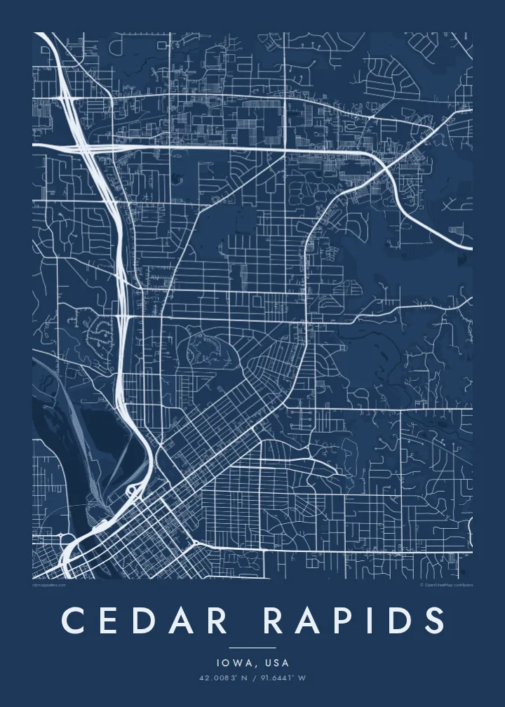
42.0083° N / 91.6441° W
A river city split diagonally by the Cedar, with an island at its centre and four quadrants of numbered streets.



Адзін горад — пяць настрояў
Дакраніцеся да стылю, каб убачыць яго на сцяне. Усе стылі каштуюць аднолькава — друкаваны варыянт, у раме або HD-файлы.
 Рэальныя пікселі · файл для друку 24 × 36″
Выразна ў друку
Гэта 100% фрагмент сапраўднага файла для друку. Кожны постар — надрукаваны, у раме або спампаваны — рэндэрыцца на нашых серверах пры 300 DPI, да 7,200 × 10,800 пікселяў, таму нават самыя дробныя вулачкі застаюцца выразнымі пры друку 24 × 36″.
На сцяне


Карта
From above, Cedar Rapids is organised around the Cedar River, which cuts through the city from northwest to southeast. Streets and avenues are numbered and labelled by quadrant (NE, NW, SE and SW), so the map reads as four grids meeting at the water. Downtown sits on the east bank, and a series of bridges connects it to the west side and to Mays Island in the middle of the channel.
Mays Island is the detail most people remember. Civic buildings stand on it, which makes Cedar Rapids one of very few American cities with its seat of government on a river island. A short walk upstream, the large Quaker Oats plant reflects the city's long connection to grain processing, and on some days the smell of toasted oats drifts across downtown.
A Cedar Rapids map poster shows the whole arrangement at once: the river, the island, Interstate 380 curving through the centre and residential blocks spreading toward the farmland of eastern Iowa. The painter Grant Wood lived and worked here, and his ordered, clean-lined view of the Midwest suits the calm geometry of a black-and-white street map.
A narrow island in the Cedar River holding civic buildings, linked to both banks by bridges. On the poster it appears as a small block of streets floating in the middle of the water.
Numbered streets and avenues divide into NE, NW, SE and SW sections. The result is four slightly offset grids that meet along the river and give the map its structure.
The interstate runs north to south through the city and crosses the river close to downtown. Its long, smooth curves stand out against the square blocks on either side.
Зрабіце яго сваім
Дадайце дату, імя ці свой радок, змяніце стыль, памер або арыентацыю.
Бясплатны прэв'ю — нізкай якасці і з вадзяным знакам. Друкаваныя постары і HD-файлы рэндэрацца пры 300 DPI, да 7,200 × 10,800 пікселяў, без вадзянога знака.
Чаму Cedar Rapids
Cedar Rapids maps tend to go to people with a long attachment to the city: those who grew up in its quadrants, worked in its plants and offices, or helped rebuild after the 2008 flood. The river and the island make the layout recognisable even without labels.
The title, subtitle and coordinates line can all be personalised, for example with a family name or a date that matters, and the map comes in five styles: Classic black & white, Noir, Paper, Blueprint and Sand. Choose the $9 digital HD files or a printed poster with an optional wooden frame.
Замовіць постар Cedar Rapids| Памер друку | Раздзяляльнасць | Файлы |
|---|---|---|
| 30 × 40 cm (11.8 × 15.7″) | 3,543 × 4,724 px | PNG · PDF |
| 29.7 × 42 cm (A3, 11.7 × 16.5″) | 3,508 × 4,961 px | PNG · PDF |
| 42 × 59.4 cm (A2, 16.5 × 23.4″) | 4,961 × 7,016 px | PNG · PDF |
| 45.7 × 61 cm (18 × 24″) | 5,400 × 7,200 px | PNG · PDF |
| 50 × 70 cm (19.7 × 27.6″) | 5,906 × 8,268 px | PNG · PDF |
| 61 × 91.4 cm (24 × 36″) | 7,200 × 10,800 px | PNG · PDF |
Для параўнання: бясплатны прагляд мае шырыню 900 px, вадзяны знак і прызначаны для экранаў. HD-файлы маюць да 8× большую раздзяляльнасць па кожным баку і чыста друкуюцца ў поўным памеры постара.
Выберыце стыль уверсе старонкі, а потым — друкаваны постар (памер і, пры жаданні, раму) або лічбавыя HD-файлы. Афармленне заказу займае адзін крок, і старонка заказу абновіцца адразу пасля аплаты.
Ён друкуецца на прэміум матавай паперы 200 г/м² у адным з шасці памераў — ад 30 × 40 см да 24 × 36″. Друкаваныя постары каштуюць ад {printFrom}, дастаўка ўключана.
Так. Выберыце раму з масіву дрэва — чорную, белую, натуральны дуб або цёмнае дрэва. Яна пастаўляецца з ударамоцным шклом і гатовая да развешвання. Постары ў раме каштуюць ад {framedFrom}, дастаўка ўключана.
Дастаўка бясплатная ва ўсім свеце. Кожны плакат друкуецца ў бліжэйшага з нашых партнёраў-друкарняў у 30+ краінах і звычайна прыходзіць за 3–7 працоўных дзён. Статус і трэкінг можна адсочваць у раздзеле «Мае заказы». У некаторыя краіны дастаўка займае 2–5 тыдняў, а калі мы туды яшчэ не дастаўляем, сайт папярэдзіць вас да аплаты.
Дашліце нам фота на працягу 14 дзён пасля атрымання, і мы бясплатна надрукуем новы або вернем грошы.
Так. У рэдактары на гэтай старонцы зменіце загаловак, падзагаловак і радок з каардынатамі на што заўгодна, а таксама выберыце стыль і памер. Друкаваныя, у раме і лічбавыя заказы выкарыстоўваюць менавіта ваш дызайн.
За $9 вы атрымаеце PNG пры 300 DPI і гатовыя да друку PDF-файлы ва ўсіх шасці памерах, без вадзянога знака, для друку дзе заўгодна. Яшчэ не ўпэўненыя? Спачатку спампуйце бясплатны прэв'ю з вадзяным знакам.
