Niger–Benue confluence
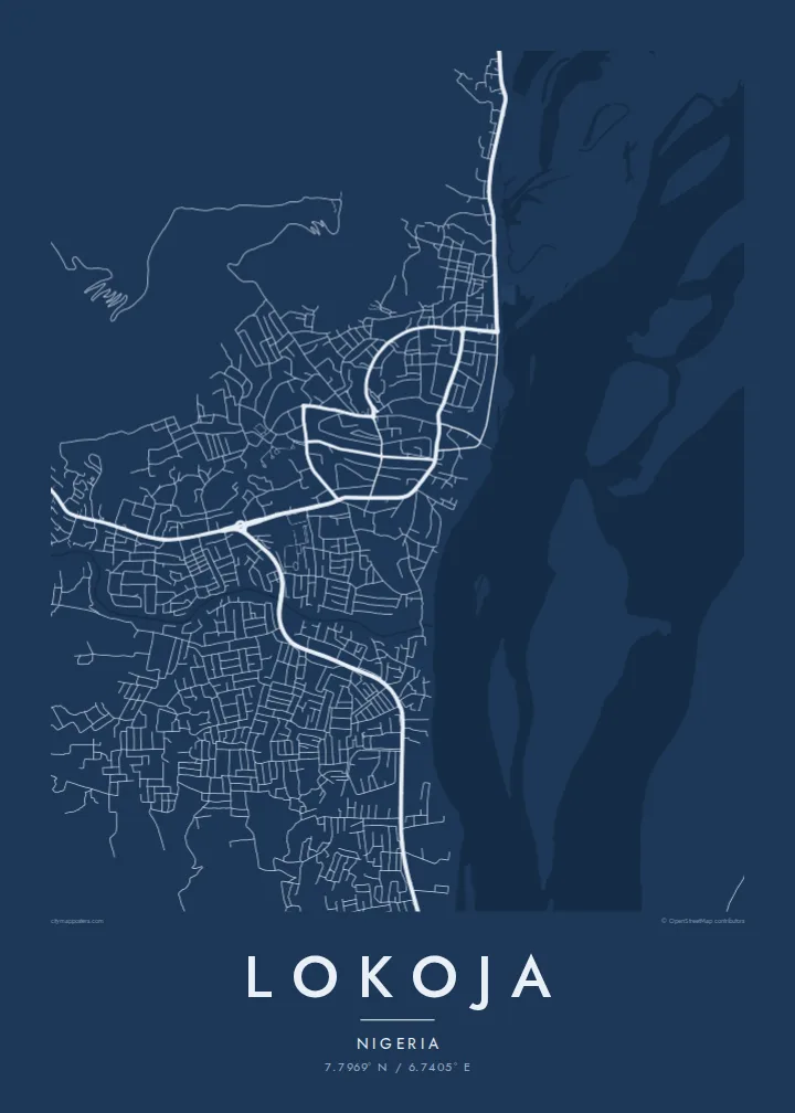
The meeting of Nigeria's two largest rivers dominates the map, a broad Y of open water with sandbars and islands that makes the town's position instantly recognisable.
Мінімалістычны постар з картай · Нігерыя
7.7969° N / 6.7405° E
Two great rivers meet in a wide Y beneath a flat-topped hill, with the town strung along the western bank.



Адзін горад — пяць настрояў
Дакраніцеся да стылю, каб убачыць яго на сцяне. Усе стылі каштуюць аднолькава — друкаваны варыянт, у раме або HD-файлы.
 Рэальныя пікселі · файл для друку 24 × 36″
Выразна ў друку
Гэта 100% фрагмент сапраўднага файла для друку. Кожны постар — надрукаваны, у раме або спампаваны — рэндэрыцца на нашых серверах пры 300 DPI, да 7,200 × 10,800 пікселяў, таму нават самыя дробныя вулачкі застаюцца выразнымі пры друку 24 × 36″.
На сцяне


Карта
Lokoja sits where the Niger and the Benue join, and on a map that confluence is the whole composition. Two broad channels arrive from the north-west and north-east, merge into a single river flowing south, and leave sandbanks and braided islands in their wake. The town itself runs along the west bank in a narrow band, held between the water and the rising ground behind it.
Above the streets, Mount Patti climbs steeply, its plateau top reached by winding roads and tracks. The hill is tied to a widely told story: the name Nigeria is said to have been coined while looking out over this confluence. Lokoja also served as an early administrative centre under British rule, and today it is the capital of Kogi State, a crossroads between the north and south of the country.
A Lokoja map poster reduces all of this to line and space: the dense streets near the river, the highway threading north towards Abuja, and the pale expanse of water that fills much of the frame. Few city maps are so clearly organised around one natural event, and the result reads almost like a diagram of how rivers shape the places that grow beside them.
The meeting of Nigeria's two largest rivers dominates the map, a broad Y of open water with sandbars and islands that makes the town's position instantly recognisable.
The steep hill rising directly behind the town appears as a tight knot of winding roads, a strong contrast to the flat river plain spread out below it.
Squeezed between hill and water, Lokoja's streets form a long, narrow band that follows the west bank, with newer growth pushing along the main roads.
Зрабіце яго сваім
Дадайце дату, імя ці свой радок, змяніце стыль, памер або арыентацыю.
Бясплатны прэв'ю — нізкай якасці і з вадзяным знакам. Друкаваныя постары і HD-файлы рэндэрацца пры 300 DPI, да 7,200 × 10,800 пікселяў, без вадзянога знака.
Чаму Lokoja
For people from Kogi State, or anyone who has crossed the confluence, this map holds a sense of arrival: the point where two rivers and several highways come together. It works as a quiet reminder of home, a posting, a journey or a family story tied to the town.
You can set your own title, subtitle and coordinates line, adding a date or a name, and choose from Classic black & white, Noir, Paper, Blueprint or Sand. The HD files cost $9 and arrive without a watermark, or you can order a matte print from partners in more than 30 countries.
Замовіць постар Lokoja| Памер друку | Раздзяляльнасць | Файлы |
|---|---|---|
| 30 × 40 cm (11.8 × 15.7″) | 3,543 × 4,724 px | PNG · PDF |
| 29.7 × 42 cm (A3, 11.7 × 16.5″) | 3,508 × 4,961 px | PNG · PDF |
| 42 × 59.4 cm (A2, 16.5 × 23.4″) | 4,961 × 7,016 px | PNG · PDF |
| 45.7 × 61 cm (18 × 24″) | 5,400 × 7,200 px | PNG · PDF |
| 50 × 70 cm (19.7 × 27.6″) | 5,906 × 8,268 px | PNG · PDF |
| 61 × 91.4 cm (24 × 36″) | 7,200 × 10,800 px | PNG · PDF |
Для параўнання: бясплатны прагляд мае шырыню 900 px, вадзяны знак і прызначаны для экранаў. HD-файлы маюць да 8× большую раздзяляльнасць па кожным баку і чыста друкуюцца ў поўным памеры постара.
Выберыце стыль уверсе старонкі, а потым — друкаваны постар (памер і, пры жаданні, раму) або лічбавыя HD-файлы. Афармленне заказу займае адзін крок, і старонка заказу абновіцца адразу пасля аплаты.
Ён друкуецца на прэміум матавай паперы 200 г/м² у адным з шасці памераў — ад 30 × 40 см да 24 × 36″. Друкаваныя постары каштуюць ад $39, дастаўка ўключана.
Так. Выберыце раму з масіву дрэва — чорную, белую, натуральны дуб або цёмнае дрэва. Яна пастаўляецца з ударамоцным шклом і гатовая да развешвання. Постары ў раме каштуюць ад $99, дастаўка ўключана.
Дастаўка бясплатная ва ўсім свеце. Кожны плакат друкуецца ў бліжэйшага з нашых партнёраў-друкарняў у 30+ краінах і звычайна прыходзіць за 3–7 працоўных дзён. Статус і трэкінг можна адсочваць у раздзеле «Мае заказы». У некаторыя краіны дастаўка займае 2–5 тыдняў, а калі мы туды яшчэ не дастаўляем, сайт папярэдзіць вас да аплаты.
Дашліце нам фота на працягу 14 дзён пасля атрымання, і мы бясплатна надрукуем новы або вернем грошы.
Так. У рэдактары на гэтай старонцы зменіце загаловак, падзагаловак і радок з каардынатамі на што заўгодна, а таксама выберыце стыль і памер. Друкаваныя, у раме і лічбавыя заказы выкарыстоўваюць менавіта ваш дызайн.
За $9 вы атрымаеце PNG пры 300 DPI і гатовыя да друку PDF-файлы ва ўсіх шасці памерах, без вадзянога знака, для друку дзе заўгодна. Яшчэ не ўпэўненыя? Спачатку спампуйце бясплатны прэв'ю з вадзяным знакам.
Побач
