Livadia bay
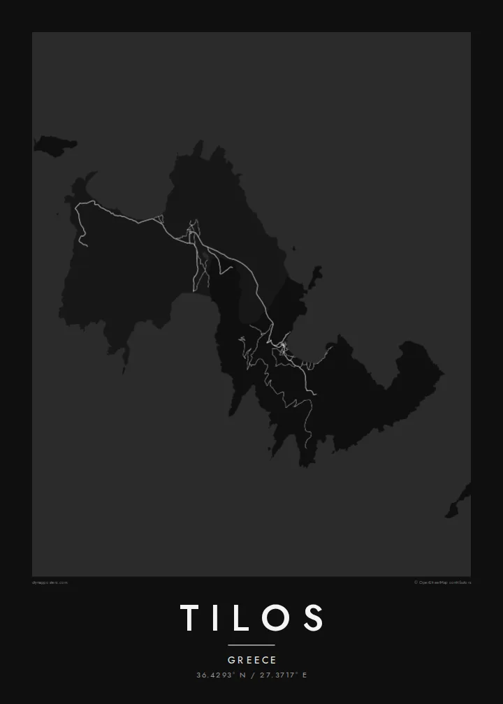
The main harbour faces a broad bay on the east coast, and its curve holds the island's largest cluster of streets. It is the natural focal point, where the ferries arrive.
Мінімалістычны постар з картай · Грэцыя
36.4293° N / 27.3717° E
A slim, mountainous Dodecanese island with a deep bay at Livadia and an inland village linked by a winding road.



Адзін горад — пяць настрояў
Дакраніцеся да стылю, каб убачыць яго на сцяне. Усе стылі каштуюць аднолькава — друкаваны варыянт, у раме або HD-файлы.
 Рэальныя пікселі · файл для друку 24 × 36″
Выразна ў друку
Гэта 100% фрагмент сапраўднага файла для друку. Кожны постар — надрукаваны, у раме або спампаваны — рэндэрыцца на нашых серверах пры 300 DPI, да 7,200 × 10,800 пікселяў, таму нават самыя дробныя вулачкі застаюцца выразнымі пры друку 24 × 36″.
На сцяне


Карта
Tilos lies between Rhodes and Kos in the Dodecanese, a narrow island of bare ridges and small valleys. On a map its outline is ragged, cut into by bays on both coasts. The harbour at Livadia sits on a wide bay on the east side. Megalo Chorio, the main village, lies inland to the west and is joined to the port by a road that winds through the hills.
For a small island, Tilos has an outsized place in natural history. Remains of dwarf elephants were found in the Charkadio cave, among the most recent of their kind in Europe. In recent decades Tilos has also become known for protecting its wildlife and for a renewable energy project that aimed to power the island largely with wind and sun.
A Tilos map poster captures the island at a readable scale. The whole coastline fits easily on the sheet, and the few roads, the lanes of the two villages and the curve of each bay add just enough detail. Nothing crowds the composition, and the broken edges of the island look especially clean in black and white.
The main harbour faces a broad bay on the east coast, and its curve holds the island's largest cluster of streets. It is the natural focal point, where the ferries arrive.
The main village sits inland below a hill crowned by a medieval castle. Its compact lanes form a tight knot of lines well away from the sea.
Beyond Megalo Chorio, a road runs down a valley to the long beach at Eristos, one of the few places where the rugged coastline opens into a wide cove.
Зрабіце яго сваім
Дадайце дату, імя ці свой радок, змяніце стыль, памер або арыентацыю.
Бясплатны прэв'ю — нізкай якасці і з вадзяным знакам. Друкаваныя постары і HD-файлы рэндэрацца пры 300 DPI, да 7,200 × 10,800 пікселяў, без вадзянога знака.
Чаму Tilos
People who have spent slow summers on Tilos tend to remember it by its walks and its quiet. A map of the island keeps the shape of those days: the bay you arrived in, the village you climbed to and the road between them. It suits a kitchen or hallway as easily as a living room.
You can rename the poster, put a date in the subtitle or adjust the coordinates line, then pick Classic black & white, Noir, Paper, Blueprint or Sand. Paper and Sand suit the Aegean light. A free 900 px watermarked preview lets you check the layout before you buy the $9 HD files.
Замовіць постар Tilos| Памер друку | Раздзяляльнасць | Файлы |
|---|---|---|
| 30 × 40 cm (11.8 × 15.7″) | 3,543 × 4,724 px | PNG · PDF |
| 29.7 × 42 cm (A3, 11.7 × 16.5″) | 3,508 × 4,961 px | PNG · PDF |
| 42 × 59.4 cm (A2, 16.5 × 23.4″) | 4,961 × 7,016 px | PNG · PDF |
| 45.7 × 61 cm (18 × 24″) | 5,400 × 7,200 px | PNG · PDF |
| 50 × 70 cm (19.7 × 27.6″) | 5,906 × 8,268 px | PNG · PDF |
| 61 × 91.4 cm (24 × 36″) | 7,200 × 10,800 px | PNG · PDF |
Для параўнання: бясплатны прагляд мае шырыню 900 px, вадзяны знак і прызначаны для экранаў. HD-файлы маюць да 8× большую раздзяляльнасць па кожным баку і чыста друкуюцца ў поўным памеры постара.
Выберыце стыль уверсе старонкі, а потым — друкаваны постар (памер і, пры жаданні, раму) або лічбавыя HD-файлы. Афармленне заказу займае адзін крок, і старонка заказу абновіцца адразу пасля аплаты.
Ён друкуецца на прэміум матавай паперы 200 г/м² у адным з шасці памераў — ад 30 × 40 см да 24 × 36″. Друкаваныя постары каштуюць ад {printFrom}, дастаўка ўключана.
Так. Выберыце раму з масіву дрэва — чорную, белую, натуральны дуб або цёмнае дрэва. Яна пастаўляецца з ударамоцным шклом і гатовая да развешвання. Постары ў раме каштуюць ад {framedFrom}, дастаўка ўключана.
Дастаўка бясплатная па ўсім свеце. Кожны постар друкуецца найбліжэйшым з нашых друкарскіх партнёраў у больш чым 30 краінах і звычайна прыходзіць за 3–7 працоўных дзён. Статус і адсочванне можна праверыць у раздзеле «Мае заказы».
Дашліце нам фота на працягу 14 дзён пасля атрымання, і мы бясплатна надрукуем новы або вернем грошы.
Так. У рэдактары на гэтай старонцы зменіце загаловак, падзагаловак і радок з каардынатамі на што заўгодна, а таксама выберыце стыль і памер. Друкаваныя, у раме і лічбавыя заказы выкарыстоўваюць менавіта ваш дызайн.
За $9 вы атрымаеце PNG пры 300 DPI і гатовыя да друку PDF-файлы ва ўсіх шасці памерах, без вадзянога знака, для друку дзе заўгодна. Яшчэ не ўпэўненыя? Спачатку спампуйце бясплатны прэв'ю з вадзяным знакам.
Побач
