Benguela Railway
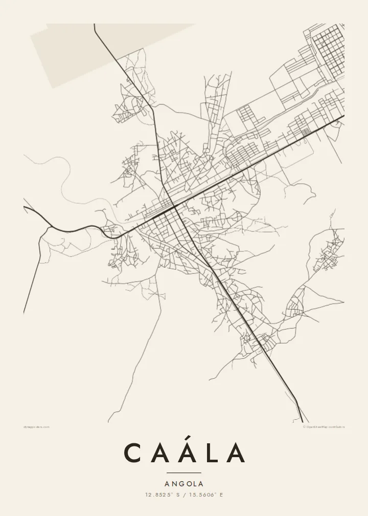
The railway line crosses the map as a long, deliberate stroke, a reminder of the route that connects the plateau with the port of Lobito and the coast.
Simpol poster blong map · Angola
12.8525° S / 15.5606° E
A highland railway town on Angola's central plateau, its streets spread along the line running toward Huambo




Wan taon, faef filing
Klikim wan style blong luk hem antap long wol. Evri style i sem prais nomo — sapos yu prinim, putum insaed frem, o daonlodem olsem HD file.
 Trufala pixel · 24 × 36″ prin file
Klia blong prent
Hemia i wan 100% haf blong trufala prin file. Evri poster — sapos prinim, putum insaed frem, o daonlodem — mifala i wokem long server blong mifala long 300 DPI, kasem 7,200 × 10,800 pixel, mekem se nomata ol smol rod tu oli klia gud long wan 24 × 36″ prin.
Long wol


Map
Caála is a town in Huambo Province, set on the high central plateau of Angola a short distance west of the provincial capital. The Benguela Railway, which links the Atlantic coast with the interior, passes through, and on a map the tracks form a long, steady line that the town has grown around.
The plateau here is open and rolling, with farmland and scattered settlements between the towns. Caála's centre has a modest grid of streets from the colonial period, while newer neighbourhoods extend outward in a looser pattern along the roads that lead toward Huambo and the surrounding countryside.
A Caála map poster keeps this simple structure clear: the railway, the central blocks and the roads reaching out across the plateau. It is a spare, honest map, well suited to anyone with roots in the Angolan highlands.
The railway line crosses the map as a long, deliberate stroke, a reminder of the route that connects the plateau with the port of Lobito and the coast.
A small, regular grid marks the older part of town, contrasting with the more open and irregular neighbourhoods that have grown up around it.
The main road east toward Huambo ties Caála to the nearby provincial capital and gives the composition a clear direction across the plateau.
Mekem i blong yu
Putum wan dei, wan nem o wan laen blong yu, jenisim stael, saes o saed.
Fri preview i lo-resolusen mo i gat watermak. Prin mo HD file oli wok long 300 DPI, kasem 7,200 × 10,800 px, i no gat watermak.
From wanem Caála
Caála is rarely seen on posters, which makes a map of it all the more personal for people who grew up there or have family on the plateau. Its open layout leaves room for a strong title.
Personalise the title, subtitle and coordinates, then choose one of five styles. Paper and Sand bring out the warmth of the highland landscape, while Classic black & white keeps the railway line crisp.
Odarem poster blong Caála| Saes blong prent | Rezolusen | Ol fael |
|---|---|---|
| 30 × 40 cm (11.8 × 15.7″) | 3,543 × 4,724 px | PNG · PDF |
| 29.7 × 42 cm (A3, 11.7 × 16.5″) | 3,508 × 4,961 px | PNG · PDF |
| 42 × 59.4 cm (A2, 16.5 × 23.4″) | 4,961 × 7,016 px | PNG · PDF |
| 45.7 × 61 cm (18 × 24″) | 5,400 × 7,200 px | PNG · PDF |
| 50 × 70 cm (19.7 × 27.6″) | 5,906 × 8,268 px | PNG · PDF |
| 61 × 91.4 cm (24 × 36″) | 7,200 × 10,800 px | PNG · PDF |
Blong yu save komperem, fri priviu i 900 px long waed, i gat wotamak mo i blong skrin nomo. Ol HD fael oli gat kasem 8× moa rezolusen long evri saed mo oli prent klia long ful saes blong poster.
Jusum wan style antap long pej, biaen jusum Prinim Poster — wan saes mo, sapos yu wantem, wan frem — o Digital HD Files. Pemen i wan step nomo, mo pej blong oda blong yu i apdet stret taem pemen i pas.
Mifala i prinim long gudfala 200 gsm matte pepa, long wan long 6 saes, statem long 30 × 40 cm kasem 24 × 36″. Prin poster i statem long {printFrom}, sipin i insaed finis.
Yes. Jusum wan strong wud frem long kala blak, waet, natural oak, o tudak wud. I gat glas we i no save brok isi, mo i rere blong hangem stret. Poster wetem frem i statem long {framedFrom}, sipin i insaed finis.
Delivri blong poster i fri long olgeta ples long wol. Wan wan poster i prin long wan long ol prin patna blong mifala we i kolosap moa long yu, long moa long 30 kantri, mo bambae i kasem yu long 3–7 wokdei. Yu save lukluk stetes mo trakin long My Orders. Sam kantri i tekem 2–5 wik, mo long ol ples we mifala i no save sendem yet, saet i talem yu bifo yu pem.
Sendem wan foto long mifala insaed 14 dei afta i kasem yu, mo mifala bae i prinim wan niufala fri o givim bak mane blong yu.
Yes. Long editor long pej ya, jenisim taetol, sabtaetol, mo laen blong koordinet i go long wanem yu wantem, mo jusum wan style mo saes. Prin, frem, mo digital oda oli yusum stret design blong yu.
Long $9 yu kasem 300 DPI PNG mo PDF file we i rere blong prinim, long evri 6 saes, i no gat watermak, mo yu save prinim long enisave ples. Yu no sua yet? Daonlodem wan fri preview wetem watermak fastaem.
Klosap
