Mays Island
A narrow island in the Cedar River holding civic buildings, linked to both banks by bridges. On the poster it appears as a small block of streets floating in the middle of the water.
Simpol poster blong map · United States
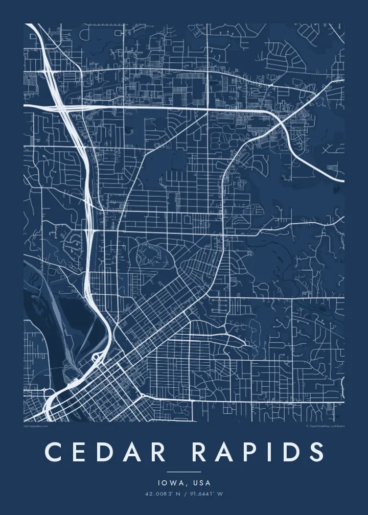
42.0083° N / 91.6441° W
A river city split diagonally by the Cedar, with an island at its centre and four quadrants of numbered streets.



Wan taon, faef filing
Klikim wan style blong luk hem antap long wol. Evri style i sem prais nomo — sapos yu prinim, putum insaed frem, o daonlodem olsem HD file.
 Trufala pixel · 24 × 36″ prin file
Klia blong prent
Hemia i wan 100% haf blong trufala prin file. Evri poster — sapos prinim, putum insaed frem, o daonlodem — mifala i wokem long server blong mifala long 300 DPI, kasem 7,200 × 10,800 pixel, mekem se nomata ol smol rod tu oli klia gud long wan 24 × 36″ prin.
Long wol


Map
From above, Cedar Rapids is organised around the Cedar River, which cuts through the city from northwest to southeast. Streets and avenues are numbered and labelled by quadrant (NE, NW, SE and SW), so the map reads as four grids meeting at the water. Downtown sits on the east bank, and a series of bridges connects it to the west side and to Mays Island in the middle of the channel.
Mays Island is the detail most people remember. Civic buildings stand on it, which makes Cedar Rapids one of very few American cities with its seat of government on a river island. A short walk upstream, the large Quaker Oats plant reflects the city's long connection to grain processing, and on some days the smell of toasted oats drifts across downtown.
A Cedar Rapids map poster shows the whole arrangement at once: the river, the island, Interstate 380 curving through the centre and residential blocks spreading toward the farmland of eastern Iowa. The painter Grant Wood lived and worked here, and his ordered, clean-lined view of the Midwest suits the calm geometry of a black-and-white street map.
A narrow island in the Cedar River holding civic buildings, linked to both banks by bridges. On the poster it appears as a small block of streets floating in the middle of the water.
Numbered streets and avenues divide into NE, NW, SE and SW sections. The result is four slightly offset grids that meet along the river and give the map its structure.
The interstate runs north to south through the city and crosses the river close to downtown. Its long, smooth curves stand out against the square blocks on either side.
Mekem i blong yu
Putum wan dei, wan nem o wan laen blong yu, jenisim stael, saes o saed.
Fri preview i lo-resolusen mo i gat watermak. Prin mo HD file oli wok long 300 DPI, kasem 7,200 × 10,800 px, i no gat watermak.
From wanem Cedar Rapids
Cedar Rapids maps tend to go to people with a long attachment to the city: those who grew up in its quadrants, worked in its plants and offices, or helped rebuild after the 2008 flood. The river and the island make the layout recognisable even without labels.
The title, subtitle and coordinates line can all be personalised, for example with a family name or a date that matters, and the map comes in five styles: Classic black & white, Noir, Paper, Blueprint and Sand. Choose the $9 digital HD files or a printed poster with an optional wooden frame.
Odarem poster blong Cedar Rapids| Saes blong prent | Rezolusen | Ol fael |
|---|---|---|
| 30 × 40 cm (11.8 × 15.7″) | 3,543 × 4,724 px | PNG · PDF |
| 29.7 × 42 cm (A3, 11.7 × 16.5″) | 3,508 × 4,961 px | PNG · PDF |
| 42 × 59.4 cm (A2, 16.5 × 23.4″) | 4,961 × 7,016 px | PNG · PDF |
| 45.7 × 61 cm (18 × 24″) | 5,400 × 7,200 px | PNG · PDF |
| 50 × 70 cm (19.7 × 27.6″) | 5,906 × 8,268 px | PNG · PDF |
| 61 × 91.4 cm (24 × 36″) | 7,200 × 10,800 px | PNG · PDF |
Blong yu save komperem, fri priviu i 900 px long waed, i gat wotamak mo i blong skrin nomo. Ol HD fael oli gat kasem 8× moa rezolusen long evri saed mo oli prent klia long ful saes blong poster.
Jusum wan style antap long pej, biaen jusum Prinim Poster — wan saes mo, sapos yu wantem, wan frem — o Digital HD Files. Pemen i wan step nomo, mo pej blong oda blong yu i apdet stret taem pemen i pas.
Mifala i prinim long gudfala 200 gsm matte pepa, long wan long 6 saes, statem long 30 × 40 cm kasem 24 × 36″. Prin poster i statem long $39, sipin i insaed finis.
Yes. Jusum wan strong wud frem long kala blak, waet, natural oak, o tudak wud. I gat glas we i no save brok isi, mo i rere blong hangem stret. Poster wetem frem i statem long $99, sipin i insaed finis.
Delivri blong poster i fri long olgeta ples long wol. Wan wan poster i prin long wan long ol prin patna blong mifala we i kolosap moa long yu, long moa long 30 kantri, mo bambae i kasem yu long 3–7 wokdei. Yu save lukluk stetes mo trakin long My Orders. Sam kantri i tekem 2–5 wik, mo long ol ples we mifala i no save sendem yet, saet i talem yu bifo yu pem.
Sendem wan foto long mifala insaed 14 dei afta i kasem yu, mo mifala bae i prinim wan niufala fri o givim bak mane blong yu.
Yes. Long editor long pej ya, jenisim taetol, sabtaetol, mo laen blong koordinet i go long wanem yu wantem, mo jusum wan style mo saes. Prin, frem, mo digital oda oli yusum stret design blong yu.
Long $9 yu kasem 300 DPI PNG mo PDF file we i rere blong prinim, long evri 6 saes, i no gat watermak, mo yu save prinim long enisave ples. Yu no sua yet? Daonlodem wan fri preview wetem watermak fastaem.
Klosap
