Kasai River
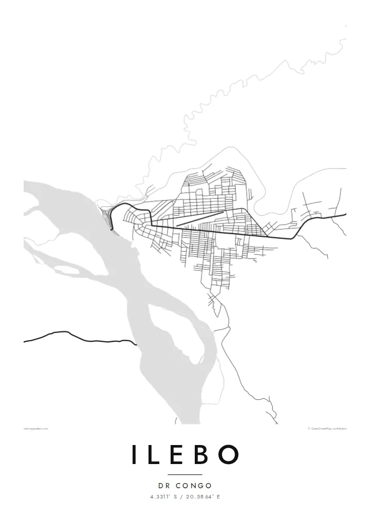
The wide river bends past the town, dominating the composition and showing why Ilebo became a port for traffic heading downstream.
Simpol poster blong map · Congo - Kinshasa
4.3311° S / 20.5864° E
A river port on a broad bend of the Kasai, where the railway from the south ends at the water's edge.


Wan taon, faef filing
Klikim wan style blong luk hem antap long wol. Evri style i sem prais nomo — sapos yu prinim, putum insaed frem, o daonlodem olsem HD file.
 Trufala pixel · 24 × 36″ prin file
Klia blong prent
Hemia i wan 100% haf blong trufala prin file. Evri poster — sapos prinim, putum insaed frem, o daonlodem — mifala i wokem long server blong mifala long 300 DPI, kasem 7,200 × 10,800 pixel, mekem se nomata ol smol rod tu oli klia gud long wan 24 × 36″ prin.
Long wol


Map
Ilebo stands on the Kasai River in the Kasai province of the Democratic Republic of the Congo. During the colonial period it was called Port-Francqui. The town grew as a transfer point: the railway from the mining regions of the southeast ends here, and cargo can continue by river toward Kinshasa.
That role is visible on the map. The river runs wide across the frame, the port area sits along the bank and the rail line arrives from the southeast into a short network of sidings and yards. Residential districts extend inland from the river in a loose pattern, bordered by forest and savanna.
An Ilebo map poster is a quiet study of infrastructure and landscape together. The river provides a broad, smooth shape, the railway a thin straight line, and the town fills the space where they meet. It suits anyone with a connection to the Kasai or an interest in how rivers and railways shaped Central Africa.
The wide river bends past the town, dominating the composition and showing why Ilebo became a port for traffic heading downstream.
The line from the southeast ends near the riverbank, where its tracks meet the port in a small cluster of sidings and yards.
Streets extend back from the bank in a loose grid, thinning out as the town meets the surrounding forest and open country.
Mekem i blong yu
Putum wan dei, wan nem o wan laen blong yu, jenisim stael, saes o saed.
Fri preview i lo-resolusen mo i gat watermak. Prin mo HD file oli wok long 300 DPI, kasem 7,200 × 10,800 px, i no gat watermak.
From wanem Ilebo
Ilebo is a place many people know through work, family or travel on the river and railway. A map of the town and the Kasai keeps that connection in a simple, calm form.
Add your own title and subtitle, a date or the old name Port-Francqui, and choose one of five styles: Classic black & white, Noir, Paper, Blueprint or Sand. The river looks especially good in Blueprint.
Odarem poster blong Ilebo| Saes blong prent | Rezolusen | Ol fael |
|---|---|---|
| 30 × 40 cm11.8 × 15.7″ | 3,543 × 4,724 px | PNG · PDF |
| 29.7 × 42 cm (A3)11.7 × 16.5″ | 3,508 × 4,961 px | PNG · PDF |
| 42 × 59.4 cm (A2)16.5 × 23.4″ | 4,961 × 7,016 px | PNG · PDF |
| 45.7 × 61 cm18 × 24″ | 5,400 × 7,200 px | PNG · PDF |
| 50 × 70 cm19.7 × 27.6″ | 5,906 × 8,268 px | PNG · PDF |
| 61 × 91.4 cm24 × 36″ | 7,200 × 10,800 px | PNG · PDF |
Blong yu save komperem, fri priviu i 900 px long waed, i gat wotamak mo i blong skrin nomo. Ol HD fael oli gat kasem 8× moa rezolusen long evri saed mo oli prent klia long ful saes blong poster.
Jusum wan style antap long pej, biaen jusum Prinim Poster — wan saes mo, sapos yu wantem, wan frem — o Digital HD Files. Pemen i wan step nomo, mo pej blong oda blong yu i apdet stret taem pemen i pas.
Mifala i prinim long gudfala 200 gsm matte pepa, long wan long 6 saes, statem long 30 × 40 cm kasem 24 × 36″. Prin poster i statem long $39, sipin i insaed finis.
Yes. Jusum wan strong wud frem long kala blak, waet, natural oak, o tudak wud. I gat glas we i no save brok isi, mo i rere blong hangem stret. Poster wetem frem i statem long $99, sipin i insaed finis.
Shipping i fri i go long 60+ kantri. Evri poster i kam from wan long ol prin pATna blong mifala we i stap kolosap moa long 30+ kantri, mo i save kasem yu long 3–7 wokin dei. Yu save lukluk stetus mo tracking long My Orders. Sam kantri i tekem 2–5 wik, mo long ol ples we mifala i no sendem yet, saet i talem yu bifo yu pem.
Sendem wan foto long mifala insaed 14 dei afta i kasem yu, mo mifala bae i prinim wan niufala fri o givim bak mane blong yu.
Yes. Long editor long pej ya, jenisim taetol, sabtaetol, mo laen blong koordinet i go long wanem yu wantem, mo jusum wan style mo saes. Prin, frem, mo digital oda oli yusum stret design blong yu.
Long $9 yu kasem 300 DPI PNG mo PDF file we i rere blong prinim, long evri 6 saes, i no gat watermak, mo yu save prinim long enisave ples. Yu no sua yet? Daonlodem wan fri preview wetem watermak fastaem.
Klosap
