Excavated harbour
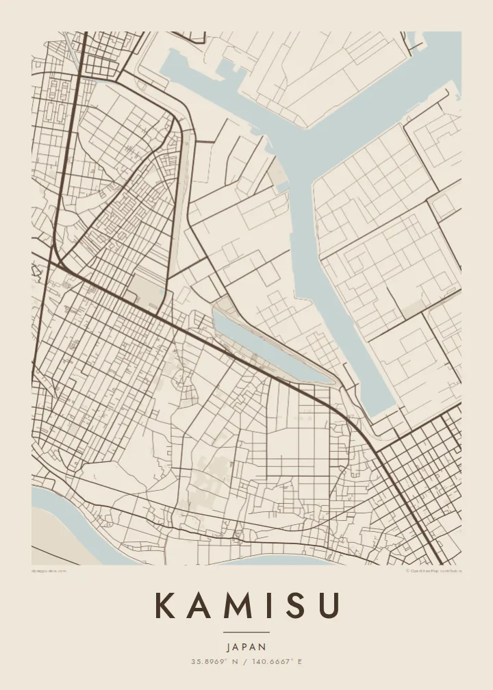
A large port basin was dug into the coast to serve heavy industry. Its straight quays and branching channels make the most striking shape on the map.
Simpol poster blong map · Japan
35.8969° N / 140.6667° E
A coastal industrial city on the Pacific shore of Ibaraki, set between a long sandy beach, a dug-out port and the lower Tone.


Wan taon, faef filing
Klikim wan style blong luk hem antap long wol. Evri style i sem prais nomo — sapos yu prinim, putum insaed frem, o daonlodem olsem HD file.
 Trufala pixel · 24 × 36″ prin file
Klia blong prent
Hemia i wan 100% haf blong trufala prin file. Evri poster — sapos prinim, putum insaed frem, o daonlodem — mifala i wokem long server blong mifala long 300 DPI, kasem 7,200 × 10,800 pixel, mekem se nomata ol smol rod tu oli klia gud long wan 24 × 36″ prin.
Long wol


Map
Kamisu occupies the southern part of a long, low strip of land on the eastern edge of Ibaraki. The Pacific lies on one side, and the waterways of the lower Tone River region lie inland. On a map, a straight, unbroken coastline runs along its east. Just inland, a large artificial harbour and industrial zone have been cut into the land.
This is part of the Kashima coastal industrial area, developed in the second half of the twentieth century around an excavated port. Petrochemical plants, steelworks and storage facilities occupy large, regular sites. Residential neighbourhoods, farmland and pine woods fill the remaining ground, and wind turbines stand along parts of the coast.
A Kamisu map poster shows an unusual mix: the clean line of the Pacific shore, the angular basins of the man-made port, the large blocks of industry and the smaller streets of the towns around them. It is a map shaped as much by engineering as by nature.
A large port basin was dug into the coast to serve heavy industry. Its straight quays and branching channels make the most striking shape on the map.
A long, nearly straight sandy coast runs along the eastern side. It sets a clean edge that contrasts with the complex industrial forms inland.
To the west and south, the rivers and wetlands of the lower Tone basin soften the map. They add curving lines against the rectilinear industrial zone.
Mekem i blong yu
Putum wan dei, wan nem o wan laen blong yu, jenisim stael, saes o saed.
Fri preview i lo-resolusen mo i gat watermak. Prin mo HD file oli wok long 300 DPI, kasem 7,200 × 10,800 px, i no gat watermak.
From wanem Kamisu
For people who work in the Kashima industrial zone or grew up along this coast, Kamisu is a place of shifts, sea wind and long straight roads. Its map is bold and geometric, and it makes a strong image.
Personalise the title, subtitle and coordinates line, and choose Classic black & white, Noir, Paper, Blueprint or Sand. The $9 download includes six sizes. Prints come on matte paper with an optional wooden frame.
Odarem poster blong Kamisu| Saes blong prent | Rezolusen | Ol fael |
|---|---|---|
| 30 × 40 cm11.8 × 15.7″ | 3,543 × 4,724 px | PNG · PDF |
| 29.7 × 42 cm (A3)11.7 × 16.5″ | 3,508 × 4,961 px | PNG · PDF |
| 42 × 59.4 cm (A2)16.5 × 23.4″ | 4,961 × 7,016 px | PNG · PDF |
| 45.7 × 61 cm18 × 24″ | 5,400 × 7,200 px | PNG · PDF |
| 50 × 70 cm19.7 × 27.6″ | 5,906 × 8,268 px | PNG · PDF |
| 61 × 91.4 cm24 × 36″ | 7,200 × 10,800 px | PNG · PDF |
Blong yu save komperem, fri priviu i 900 px long waed, i gat wotamak mo i blong skrin nomo. Ol HD fael oli gat kasem 8× moa rezolusen long evri saed mo oli prent klia long ful saes blong poster.
Jusum wan style antap long pej, biaen jusum Prinim Poster — wan saes mo, sapos yu wantem, wan frem — o Digital HD Files. Pemen i wan step nomo, mo pej blong oda blong yu i apdet stret taem pemen i pas.
Mifala i prinim long gudfala 200 gsm matte pepa, long wan long 6 saes, statem long 30 × 40 cm kasem 24 × 36″. Prin poster i statem long $39, sipin i insaed finis.
Yes. Jusum wan strong wud frem long kala blak, waet, natural oak, o tudak wud. I gat glas we i no save brok isi, mo i rere blong hangem stret. Poster wetem frem i statem long $99, sipin i insaed finis.
Shipping i fri i go long 60+ kantri. Evri poster i kam from wan long ol prin pATna blong mifala we i stap kolosap moa long 30+ kantri, mo i save kasem yu long 3–7 wokin dei. Yu save lukluk stetus mo tracking long My Orders. Sam kantri i tekem 2–5 wik, mo long ol ples we mifala i no sendem yet, saet i talem yu bifo yu pem.
Sendem wan foto long mifala insaed 14 dei afta i kasem yu, mo mifala bae i prinim wan niufala fri o givim bak mane blong yu.
Yes. Long editor long pej ya, jenisim taetol, sabtaetol, mo laen blong koordinet i go long wanem yu wantem, mo jusum wan style mo saes. Prin, frem, mo digital oda oli yusum stret design blong yu.
Long $9 yu kasem 300 DPI PNG mo PDF file we i rere blong prinim, long evri 6 saes, i no gat watermak, mo yu save prinim long enisave ples. Yu no sua yet? Daonlodem wan fri preview wetem watermak fastaem.
Klosap
