Shire River
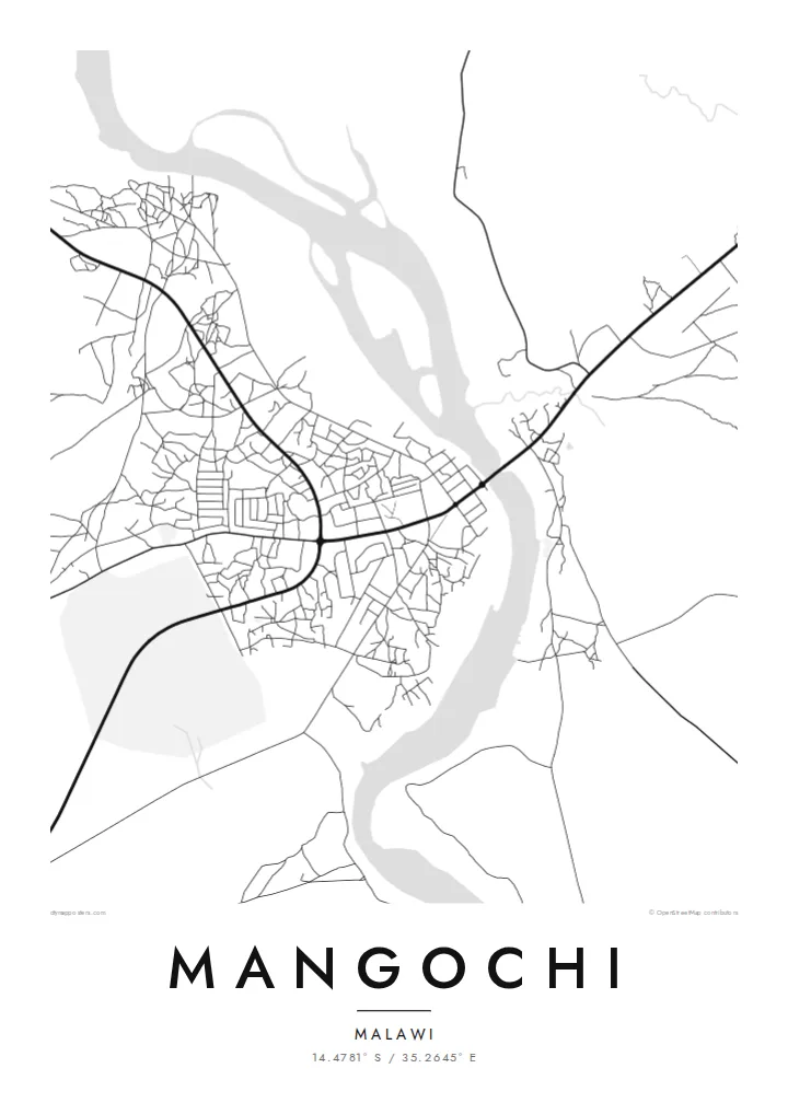
The Shire runs through the town, and its channel divides the map into two banks. A road bridge links them, making it the most important crossing in the area.
Simpol poster blong map · Malawi
14.4781° S / 35.2645° E
A lakeside town at the southern tip of Lake Malawi, where the Shire River begins its course


Wan taon, faef filing
Klikim wan style blong luk hem antap long wol. Evri style i sem prais nomo — sapos yu prinim, putum insaed frem, o daonlodem olsem HD file.
 Trufala pixel · 24 × 36″ prin file
Klia blong prent
Hemia i wan 100% haf blong trufala prin file. Evri poster — sapos prinim, putum insaed frem, o daonlodem — mifala i wokem long server blong mifala long 300 DPI, kasem 7,200 × 10,800 pixel, mekem se nomata ol smol rod tu oli klia gud long wan 24 × 36″ prin.
Long wol


Map
Mangochi lies in southern Malawi, near the point where Lake Malawi narrows and empties into the Shire River. The town stretches along the river's banks, and its map is defined by that water: the channel running south, a road bridge crossing it, and the lakeshore just to the north with beaches and fishing villages along the coast.
Under the colonial administration the town was known as Fort Johnston, and it keeps several reminders of that period, including a clock tower commemorating Queen Victoria. The Lake Malawi Museum in the town tells the story of the lake, its fishing communities and its steamers.
A Mangochi map poster brings the river and the lake together in one frame. The town's streets sit on either side of the Shire, roads lead north along the lakeshore, and the open water gives the design a large calm space. It is a simple, strong composition shaped by geography.
The Shire runs through the town, and its channel divides the map into two banks. A road bridge links them, making it the most important crossing in the area.
Just north of the town, the southern tip of Lake Malawi opens out. The long shoreline and wide water give the top of the poster a clean, open surface.
The central streets, market and older colonial buildings lie close to the river. It is the densest part of the map, with roads branching out toward the lake and the south.
Mekem i blong yu
Putum wan dei, wan nem o wan laen blong yu, jenisim stael, saes o saed.
Fri preview i lo-resolusen mo i gat watermak. Prin mo HD file oli wok long 300 DPI, kasem 7,200 × 10,800 px, i no gat watermak.
From wanem Mangochi
For people from Mangochi, and for those who have spent time on the southern lakeshore, a map of the town where the lake becomes a river is both a personal memento and a striking piece of geography.
Add a title and subtitle of your choice and set the coordinates line to a home, a school or a stretch of beach. The poster is available in Classic black & white, Noir, Paper, Blueprint and Sand.
Odarem poster blong Mangochi| Saes blong prent | Rezolusen | Ol fael |
|---|---|---|
| 30 × 40 cm11.8 × 15.7″ | 3,543 × 4,724 px | PNG · PDF |
| 29.7 × 42 cm (A3)11.7 × 16.5″ | 3,508 × 4,961 px | PNG · PDF |
| 42 × 59.4 cm (A2)16.5 × 23.4″ | 4,961 × 7,016 px | PNG · PDF |
| 45.7 × 61 cm18 × 24″ | 5,400 × 7,200 px | PNG · PDF |
| 50 × 70 cm19.7 × 27.6″ | 5,906 × 8,268 px | PNG · PDF |
| 61 × 91.4 cm24 × 36″ | 7,200 × 10,800 px | PNG · PDF |
Blong yu save komperem, fri priviu i 900 px long waed, i gat wotamak mo i blong skrin nomo. Ol HD fael oli gat kasem 8× moa rezolusen long evri saed mo oli prent klia long ful saes blong poster.
Jusum wan style antap long pej, biaen jusum Prinim Poster — wan saes mo, sapos yu wantem, wan frem — o Digital HD Files. Pemen i wan step nomo, mo pej blong oda blong yu i apdet stret taem pemen i pas.
Mifala i prinim long gudfala 200 gsm matte pepa, long wan long 6 saes, statem long 30 × 40 cm kasem 24 × 36″. Prin poster i statem long $39, sipin i insaed finis.
Yes. Jusum wan strong wud frem long kala blak, waet, natural oak, o tudak wud. I gat glas we i no save brok isi, mo i rere blong hangem stret. Poster wetem frem i statem long $99, sipin i insaed finis.
Shipping i fri i go long 60+ kantri. Evri poster i kam from wan long ol prin pATna blong mifala we i stap kolosap moa long 30+ kantri, mo i save kasem yu long 3–7 wokin dei. Yu save lukluk stetus mo tracking long My Orders. Sam kantri i tekem 2–5 wik, mo long ol ples we mifala i no sendem yet, saet i talem yu bifo yu pem.
Sendem wan foto long mifala insaed 14 dei afta i kasem yu, mo mifala bae i prinim wan niufala fri o givim bak mane blong yu.
Yes. Long editor long pej ya, jenisim taetol, sabtaetol, mo laen blong koordinet i go long wanem yu wantem, mo jusum wan style mo saes. Prin, frem, mo digital oda oli yusum stret design blong yu.
Long $9 yu kasem 300 DPI PNG mo PDF file we i rere blong prinim, long evri 6 saes, i no gat watermak, mo yu save prinim long enisave ples. Yu no sua yet? Daonlodem wan fri preview wetem watermak fastaem.
Klosap
