Funai Castle
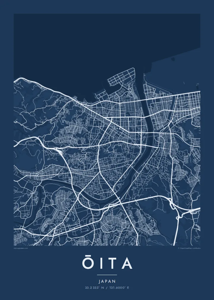
The castle ruins in the centre, with moats and stone walls, form a clear square. The surrounding streets are laid out in an orderly grid around it.
Simpol poster blong map · Japan
33.2333° N / 131.6000° E
A bayside city on Kyushu where two rivers reach the sea, with castle moats at the centre and industry along the shore



Wan taon, faef filing
Klikim wan style blong luk hem antap long wol. Evri style i sem prais nomo — sapos yu prinim, putum insaed frem, o daonlodem olsem HD file.
 Trufala pixel · 24 × 36″ prin file
Klia blong prent
Hemia i wan 100% haf blong trufala prin file. Evri poster — sapos prinim, putum insaed frem, o daonlodem — mifala i wokem long server blong mifala long 300 DPI, kasem 7,200 × 10,800 pixel, mekem se nomata ol smol rod tu oli klia gud long wan 24 × 36″ prin.
Long wol


Map
Ōita lies on the northern coast of Kyushu, facing Beppu Bay, and its map is shaped by two rivers, the Ōita and the Ōno, which reach the sea on either side of the city. Between them, the centre is laid out in a regular grid around the remains of Funai Castle, whose moats and stone walls still form a clear square in the street pattern. Much of the coastline has been reclaimed for industry.
In the sixteenth century the area was ruled by the Ōtomo clan, and under Ōtomo Sōrin the town of Funai became one of Japan's early points of contact with Europe. Francis Xavier visited in 1551. Today Ōita is the prefectural capital, and it sits right next to Beppu, one of Japan's best-known hot spring towns.
An Ōita map poster brings together the grid of the castle town, the two river mouths and the straight edges of the reclaimed coast. The hills behind the city frame it on the landward side. In black and white the castle's square moats, the river curves and the man-made shoreline create a composition that feels both historical and modern.
The castle ruins in the centre, with moats and stone walls, form a clear square. The surrounding streets are laid out in an orderly grid around it.
The Ōita and Ōno rivers enter Beppu Bay on either side of the city, framing the urban area with long, curving lines of water.
Large areas of the shore were filled in for industry. On the map they appear as straight-edged blocks pushing into the bay.
Mekem i blong yu
Putum wan dei, wan nem o wan laen blong yu, jenisim stael, saes o saed.
Fri preview i lo-resolusen mo i gat watermak. Prin mo HD file oli wok long 300 DPI, kasem 7,200 × 10,800 px, i no gat watermak.
From wanem Ōita
Ōita is a map for people from Kyushu, for those who have lived in the prefecture, and for travellers who remember the bay and the nearby hot springs. The castle square and the rivers make it easy to recognise.
Personalise the title, subtitle and coordinates line with a date or phrase, and choose Classic black & white, Noir, Paper, Blueprint or Sand. Blueprint suits the bay and the industrial coast.
Odarem poster blong Ōita| Saes blong prent | Rezolusen | Ol fael |
|---|---|---|
| 30 × 40 cm11.8 × 15.7″ | 3,543 × 4,724 px | PNG · PDF |
| 29.7 × 42 cm (A3)11.7 × 16.5″ | 3,508 × 4,961 px | PNG · PDF |
| 42 × 59.4 cm (A2)16.5 × 23.4″ | 4,961 × 7,016 px | PNG · PDF |
| 45.7 × 61 cm18 × 24″ | 5,400 × 7,200 px | PNG · PDF |
| 50 × 70 cm19.7 × 27.6″ | 5,906 × 8,268 px | PNG · PDF |
| 61 × 91.4 cm24 × 36″ | 7,200 × 10,800 px | PNG · PDF |
Blong yu save komperem, fri priviu i 900 px long waed, i gat wotamak mo i blong skrin nomo. Ol HD fael oli gat kasem 8× moa rezolusen long evri saed mo oli prent klia long ful saes blong poster.
Jusum wan style antap long pej, biaen jusum Prinim Poster — wan saes mo, sapos yu wantem, wan frem — o Digital HD Files. Pemen i wan step nomo, mo pej blong oda blong yu i apdet stret taem pemen i pas.
Mifala i prinim long gudfala 200 gsm matte pepa, long wan long 6 saes, statem long 30 × 40 cm kasem 24 × 36″. Prin poster i statem long $39, sipin i insaed finis.
Yes. Jusum wan strong wud frem long kala blak, waet, natural oak, o tudak wud. I gat glas we i no save brok isi, mo i rere blong hangem stret. Poster wetem frem i statem long $99, sipin i insaed finis.
Shipping i fri i go long 60+ kantri. Evri poster i kam from wan long ol prin pATna blong mifala we i stap kolosap moa long 30+ kantri, mo i save kasem yu long 3–7 wokin dei. Yu save lukluk stetus mo tracking long My Orders. Sam kantri i tekem 2–5 wik, mo long ol ples we mifala i no sendem yet, saet i talem yu bifo yu pem.
Sendem wan foto long mifala insaed 14 dei afta i kasem yu, mo mifala bae i prinim wan niufala fri o givim bak mane blong yu.
Yes. Long editor long pej ya, jenisim taetol, sabtaetol, mo laen blong koordinet i go long wanem yu wantem, mo jusum wan style mo saes. Prin, frem, mo digital oda oli yusum stret design blong yu.
Long $9 yu kasem 300 DPI PNG mo PDF file we i rere blong prinim, long evri 6 saes, i no gat watermak, mo yu save prinim long enisave ples. Yu no sua yet? Daonlodem wan fri preview wetem watermak fastaem.
Klosap
