Original town grid
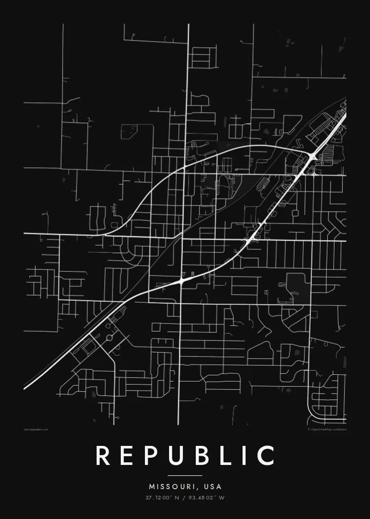
The historic centre follows a small grid of straight streets, a clear rectangular core that is still visible within the surrounding newer development.
Simpol poster blong map · United States
37.1200° N / 93.4802° W
A growing Ozarks suburb southwest of Springfield, with a small grid core surrounded by new subdivisions and farmland



Wan taon, faef filing
Klikim wan style blong luk hem antap long wol. Evri style i sem prais nomo — sapos yu prinim, putum insaed frem, o daonlodem olsem HD file.
 Trufala pixel · 24 × 36″ prin file
Klia blong prent
Hemia i wan 100% haf blong trufala prin file. Evri poster — sapos prinim, putum insaed frem, o daonlodem — mifala i wokem long server blong mifala long 300 DPI, kasem 7,200 × 10,800 pixel, mekem se nomata ol smol rod tu oli klia gud long wan 24 × 36″ prin.
Long wol


Map
Republic sits in Greene County, Missouri, just southwest of Springfield, on the gently rolling ground of the Ozarks plateau. Its original town centre is a small grid of streets, and from above it forms a compact rectangle within a much larger area of later growth.
Over recent decades the city has expanded quickly, and the map shows that growth plainly: curving subdivision streets and cul-de-sacs spreading out from the older grid, with highway corridors connecting Republic to Springfield. Beyond the edges, farmland, woodlots and creek valleys fill the rest of the frame.
Just to the south lies Wilson's Creek National Battlefield, site of one of the first major Civil War battles west of the Mississippi in 1861. A Republic map poster that extends far enough includes its open fields, a quiet contrast to the suburban patterns to the north.
The historic centre follows a small grid of straight streets, a clear rectangular core that is still visible within the surrounding newer development.
Newer neighbourhoods spread outward in curving streets and cul-de-sacs, a pattern that shows how quickly the city has grown in recent decades.
South of the city, the national battlefield preserves open fields and wooded creek valleys, forming a broad, quiet area on the map.
Mekem i blong yu
Putum wan dei, wan nem o wan laen blong yu, jenisim stael, saes o saed.
Fri preview i lo-resolusen mo i gat watermak. Prin mo HD file oli wok long 300 DPI, kasem 7,200 × 10,800 px, i no gat watermak.
From wanem Republic
Republic is the kind of place many families have moved to recently, and a map is a good way to mark that new start. It suits a first home, an entryway or a gift for someone who has just settled here.
Personalise the title, subtitle and coordinates line, adding a move-in date or street name if you wish, and choose Classic black & white, Noir, Paper, Blueprint or Sand. Download the files or order a printed poster.
Odarem poster blong Republic| Saes blong prent | Rezolusen | Ol fael |
|---|---|---|
| 30 × 40 cm11.8 × 15.7″ | 3,543 × 4,724 px | PNG · PDF |
| 29.7 × 42 cm (A3)11.7 × 16.5″ | 3,508 × 4,961 px | PNG · PDF |
| 42 × 59.4 cm (A2)16.5 × 23.4″ | 4,961 × 7,016 px | PNG · PDF |
| 45.7 × 61 cm18 × 24″ | 5,400 × 7,200 px | PNG · PDF |
| 50 × 70 cm19.7 × 27.6″ | 5,906 × 8,268 px | PNG · PDF |
| 61 × 91.4 cm24 × 36″ | 7,200 × 10,800 px | PNG · PDF |
Blong yu save komperem, fri priviu i 900 px long waed, i gat wotamak mo i blong skrin nomo. Ol HD fael oli gat kasem 8× moa rezolusen long evri saed mo oli prent klia long ful saes blong poster.
Jusum wan style antap long pej, biaen jusum Prinim Poster — wan saes mo, sapos yu wantem, wan frem — o Digital HD Files. Pemen i wan step nomo, mo pej blong oda blong yu i apdet stret taem pemen i pas.
Mifala i prinim long gudfala 200 gsm matte pepa, long wan long 6 saes, statem long 30 × 40 cm kasem 24 × 36″. Prin poster i statem long $39, sipin i insaed finis.
Yes. Jusum wan strong wud frem long kala blak, waet, natural oak, o tudak wud. I gat glas we i no save brok isi, mo i rere blong hangem stret. Poster wetem frem i statem long $99, sipin i insaed finis.
Shipping i fri i go long 60+ kantri. Evri poster i kam from wan long ol prin pATna blong mifala we i stap kolosap moa long 30+ kantri, mo i save kasem yu long 3–7 wokin dei. Yu save lukluk stetus mo tracking long My Orders. Sam kantri i tekem 2–5 wik, mo long ol ples we mifala i no sendem yet, saet i talem yu bifo yu pem.
Sendem wan foto long mifala insaed 14 dei afta i kasem yu, mo mifala bae i prinim wan niufala fri o givim bak mane blong yu.
Yes. Long editor long pej ya, jenisim taetol, sabtaetol, mo laen blong koordinet i go long wanem yu wantem, mo jusum wan style mo saes. Prin, frem, mo digital oda oli yusum stret design blong yu.
Long $9 yu kasem 300 DPI PNG mo PDF file we i rere blong prinim, long evri 6 saes, i no gat watermak, mo yu save prinim long enisave ples. Yu no sua yet? Daonlodem wan fri preview wetem watermak fastaem.
Klosap
