Genoese fort island
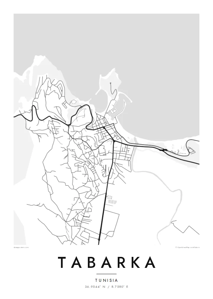
A rocky island topped with a Genoese fort sits just offshore. It shows on the map as a bold, separate shape beside the harbour.
Simpol poster blong map · Tunisia
36.9544° N / 8.7580° E
A small port town on Tunisia's north coast, with a Genoese fort on a rocky island joined by a causeway


Wan taon, faef filing
Klikim wan style blong luk hem antap long wol. Evri style i sem prais nomo — sapos yu prinim, putum insaed frem, o daonlodem olsem HD file.
 Trufala pixel · 24 × 36″ prin file
Klia blong prent
Hemia i wan 100% haf blong trufala prin file. Evri poster — sapos prinim, putum insaed frem, o daonlodem — mifala i wokem long server blong mifala long 300 DPI, kasem 7,200 × 10,800 pixel, mekem se nomata ol smol rod tu oli klia gud long wan 24 × 36″ prin.
Long wol


Map
Tabarka lies on the north-western coast of Tunisia, close to the Algerian border. Here the forested Kroumirie hills come down to the Mediterranean. On a map, the town wraps around a small bay and harbour. Just offshore sits a rocky island crowned by a fort built by the Genoese, who held it for coral fishing from the sixteenth century.
The island is joined to the mainland by a narrow causeway. Along the coast west of the harbour stand the Aiguilles, tall sea-worn rock needles that are one of the town's best-known sights. Tabarka is also known for coral diving, for the cork oak forests inland and for the music festivals held here in summer.
A Tabarka map poster is shaped by the coastline: the bay, the causeway, the island and the rocky shore beyond. It is a composition full of distinct shapes. The Sand and Paper styles suit the Mediterranean setting, while Noir sets the white coastline sharply against dark water.
A rocky island topped with a Genoese fort sits just offshore. It shows on the map as a bold, separate shape beside the harbour.
A narrow causeway links the island to the town. It draws a thin, direct line across the water that is easy to pick out.
West of the harbour, tall rock needles known as the Aiguilles line the shore. They mark one of the most recognisable stretches of coast.
Mekem i blong yu
Putum wan dei, wan nem o wan laen blong yu, jenisim stael, saes o saed.
Fri preview i lo-resolusen mo i gat watermak. Prin mo HD file oli wok long 300 DPI, kasem 7,200 × 10,800 px, i no gat watermak.
From wanem Tabarka
Tabarka is a place people return to: for diving, for festivals, or simply for the quiet of a small coastal town. A map of the bay and fort keeps that setting in view long after the trip is over.
Add your own title and subtitle, for example a year or a name, and keep the coordinates line. Then choose Classic black & white, Noir, Paper, Blueprint or Sand. Sand works especially well with this coast.
Odarem poster blong Tabarka| Saes blong prent | Rezolusen | Ol fael |
|---|---|---|
| 30 × 40 cm (11.8 × 15.7″) | 3,543 × 4,724 px | PNG · PDF |
| 29.7 × 42 cm (A3, 11.7 × 16.5″) | 3,508 × 4,961 px | PNG · PDF |
| 42 × 59.4 cm (A2, 16.5 × 23.4″) | 4,961 × 7,016 px | PNG · PDF |
| 45.7 × 61 cm (18 × 24″) | 5,400 × 7,200 px | PNG · PDF |
| 50 × 70 cm (19.7 × 27.6″) | 5,906 × 8,268 px | PNG · PDF |
| 61 × 91.4 cm (24 × 36″) | 7,200 × 10,800 px | PNG · PDF |
Blong yu save komperem, fri priviu i 900 px long waed, i gat wotamak mo i blong skrin nomo. Ol HD fael oli gat kasem 8× moa rezolusen long evri saed mo oli prent klia long ful saes blong poster.
Jusum wan style antap long pej, biaen jusum Prinim Poster — wan saes mo, sapos yu wantem, wan frem — o Digital HD Files. Pemen i wan step nomo, mo pej blong oda blong yu i apdet stret taem pemen i pas.
Mifala i prinim long gudfala 200 gsm matte pepa, long wan long 6 saes, statem long 30 × 40 cm kasem 24 × 36″. Prin poster i statem long $39, sipin i insaed finis.
Yes. Jusum wan strong wud frem long kala blak, waet, natural oak, o tudak wud. I gat glas we i no save brok isi, mo i rere blong hangem stret. Poster wetem frem i statem long $99, sipin i insaed finis.
Delivri blong poster i fri long olgeta ples long wol. Wan wan poster i prin long wan long ol prin patna blong mifala we i kolosap moa long yu, long moa long 30 kantri, mo bambae i kasem yu long 3–7 wokdei. Yu save lukluk stetes mo trakin long My Orders. Sam kantri i tekem 2–5 wik, mo long ol ples we mifala i no save sendem yet, saet i talem yu bifo yu pem.
Sendem wan foto long mifala insaed 14 dei afta i kasem yu, mo mifala bae i prinim wan niufala fri o givim bak mane blong yu.
Yes. Long editor long pej ya, jenisim taetol, sabtaetol, mo laen blong koordinet i go long wanem yu wantem, mo jusum wan style mo saes. Prin, frem, mo digital oda oli yusum stret design blong yu.
Long $9 yu kasem 300 DPI PNG mo PDF file we i rere blong prinim, long evri 6 saes, i no gat watermak, mo yu save prinim long enisave ples. Yu no sua yet? Daonlodem wan fri preview wetem watermak fastaem.
Klosap
