Harbour breakwaters
Straight concrete breakwaters and enclosed basins give the coastline a crisp, engineered edge that reads clearly against the open water of the Inland Sea.
Simpol poster blong map · Japan
34.2750° N / 133.7500° E
A low coastal town on the Seto Inland Sea, where a harbour, a railway junction and a flat plain meet



Wan taon, faef filing
Klikim wan style blong luk hem antap long wol. Evri style i sem prais nomo — sapos yu prinim, putum insaed frem, o daonlodem olsem HD file.
 Trufala pixel · 24 × 36″ prin file
Klia blong prent
Hemia i wan 100% haf blong trufala prin file. Evri poster — sapos prinim, putum insaed frem, o daonlodem — mifala i wokem long server blong mifala long 300 DPI, kasem 7,200 × 10,800 pixel, mekem se nomata ol smol rod tu oli klia gud long wan 24 × 36″ prin.
Long wol


Map
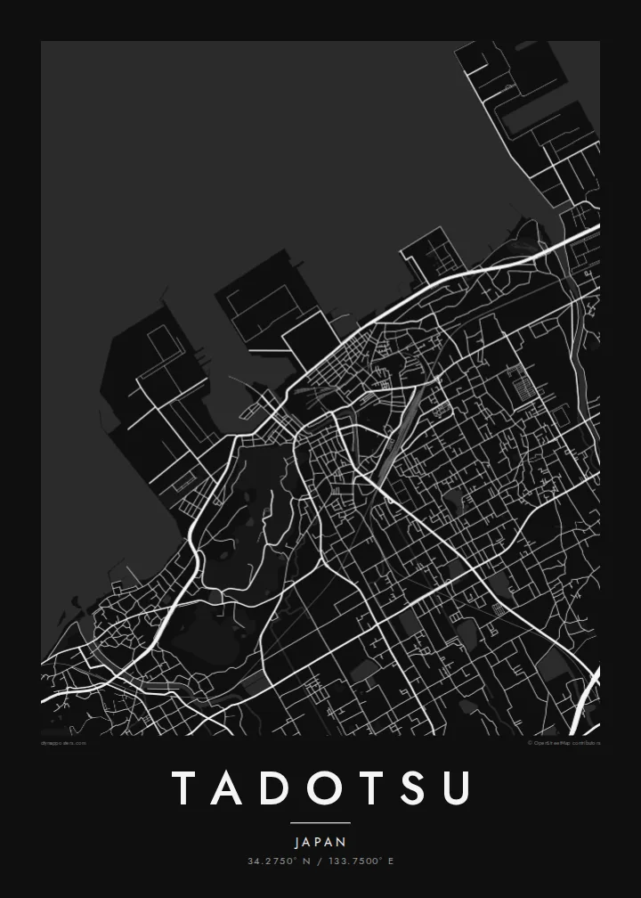
Tadotsu lies on the northern coast of Kagawa, facing the Seto Inland Sea. Seen from above, the town is a dense band of low streets along the shoreline, with harbour basins and breakwaters cutting into the water and the Sanuki plain spreading inland behind it. Small islands sit offshore, so the sea on the map is never entirely empty.
Tadotsu Station is where the Yosan Line along the coast meets the Dosan Line heading south into the mountains of Shikoku, which gives the town a railway importance larger than its size. On the map the tracks split just south of the centre, one line holding the coast and the other turning inland.
The town is also widely known as the headquarters of Shorinji Kempo, the Japanese martial art founded here after the Second World War, and practitioners from many countries visit. A Tadotsu map poster keeps all of this in a quiet frame: shoreline, harbour walls, rail lines and the fine grain of residential lanes behind the port.
Straight concrete breakwaters and enclosed basins give the coastline a crisp, engineered edge that reads clearly against the open water of the Inland Sea.
The Yosan and Dosan lines diverge near the station, a simple fork of track that anchors the centre of the town on the map.
Inland, the street pattern loosens into farmland and scattered settlement on the flat plain typical of Kagawa, dotted with small irrigation ponds.
Mekem i blong yu
Putum wan dei, wan nem o wan laen blong yu, jenisim stael, saes o saed.
Fri preview i lo-resolusen mo i gat watermak. Prin mo HD file oli wok long 300 DPI, kasem 7,200 × 10,800 px, i no gat watermak.
From wanem Tadotsu
For Shorinji Kempo practitioners, Tadotsu is a place of pilgrimage, and a map of the town is a quiet way to mark training there. For families from Kagawa it is simply home by the sea, drawn in fine lines.
Add a title, a subtitle such as a dojo name or year, and your own coordinates line, then pick one of five styles: Classic black & white, Noir, Paper, Blueprint or Sand. Paper and Sand bring out the softness of the coast.
Odarem poster blong Tadotsu| Saes blong prent | Rezolusen | Ol fael |
|---|---|---|
| 30 × 40 cm11.8 × 15.7″ | 3,543 × 4,724 px | PNG · PDF |
| 29.7 × 42 cm (A3)11.7 × 16.5″ | 3,508 × 4,961 px | PNG · PDF |
| 42 × 59.4 cm (A2)16.5 × 23.4″ | 4,961 × 7,016 px | PNG · PDF |
| 45.7 × 61 cm18 × 24″ | 5,400 × 7,200 px | PNG · PDF |
| 50 × 70 cm19.7 × 27.6″ | 5,906 × 8,268 px | PNG · PDF |
| 61 × 91.4 cm24 × 36″ | 7,200 × 10,800 px | PNG · PDF |
Blong yu save komperem, fri priviu i 900 px long waed, i gat wotamak mo i blong skrin nomo. Ol HD fael oli gat kasem 8× moa rezolusen long evri saed mo oli prent klia long ful saes blong poster.
Jusum wan style antap long pej, biaen jusum Prinim Poster — wan saes mo, sapos yu wantem, wan frem — o Digital HD Files. Pemen i wan step nomo, mo pej blong oda blong yu i apdet stret taem pemen i pas.
Mifala i prinim long gudfala 200 gsm matte pepa, long wan long 6 saes, statem long 30 × 40 cm kasem 24 × 36″. Prin poster i statem long $39, sipin i insaed finis.
Yes. Jusum wan strong wud frem long kala blak, waet, natural oak, o tudak wud. I gat glas we i no save brok isi, mo i rere blong hangem stret. Poster wetem frem i statem long $99, sipin i insaed finis.
Shipping i fri i go long 60+ kantri. Evri poster i kam from wan long ol prin pATna blong mifala we i stap kolosap moa long 30+ kantri, mo i save kasem yu long 3–7 wokin dei. Yu save lukluk stetus mo tracking long My Orders. Sam kantri i tekem 2–5 wik, mo long ol ples we mifala i no sendem yet, saet i talem yu bifo yu pem.
Sendem wan foto long mifala insaed 14 dei afta i kasem yu, mo mifala bae i prinim wan niufala fri o givim bak mane blong yu.
Yes. Long editor long pej ya, jenisim taetol, sabtaetol, mo laen blong koordinet i go long wanem yu wantem, mo jusum wan style mo saes. Prin, frem, mo digital oda oli yusum stret design blong yu.
Long $9 yu kasem 300 DPI PNG mo PDF file we i rere blong prinim, long evri 6 saes, i no gat watermak, mo yu save prinim long enisave ples. Yu no sua yet? Daonlodem wan fri preview wetem watermak fastaem.
Klosap
