Tammerkoski rapids
The short channel between the two lakes runs north to south through the centre. Former mill buildings stand along both banks, and several bridges cross it.
Simpol poster blong map · Finland
61.4991° N / 23.7871° E
An industrial city on a narrow isthmus between two great lakes, split by rapids that drop from one to the other.


Wan taon, faef filing
Klikim wan style blong luk hem antap long wol. Evri style i sem prais nomo — sapos yu prinim, putum insaed frem, o daonlodem olsem HD file.
 Trufala pixel · 24 × 36″ prin file
Klia blong prent
Hemia i wan 100% haf blong trufala prin file. Evri poster — sapos prinim, putum insaed frem, o daonlodem — mifala i wokem long server blong mifala long 300 DPI, kasem 7,200 × 10,800 pixel, mekem se nomata ol smol rod tu oli klia gud long wan 24 × 36″ prin.
Long wol


Map
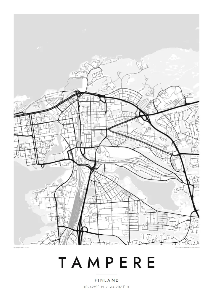
Tampere sits on a strip of land between two large lakes: Näsijärvi to the north and Pyhäjärvi to the south. The northern lake lies about eighteen metres higher, and the Tammerkoski rapids carry the water down through the middle of the city. Red-brick mills and factories line the rapids. Around them, the city centre is a clear grid of streets that runs from the rapids to the lakeshores.
King Gustav III founded Tampere in 1779, and the power of the rapids made it the heart of Finnish industrialisation. The Finlayson cotton mill is the best known example. West of the centre, the Pyynikki ridge, a long glacial esker with an observation tower, runs between the two lakes, and the Näsinneula tower rises at Särkänniemi on the northern shore.
A Tampere map poster shows the city's unusual geography at a glance. Two expanses of water, a narrow channel and a tight urban grid in between make one of the most distinctive city plans in the Nordic countries.
The short channel between the two lakes runs north to south through the centre. Former mill buildings stand along both banks, and several bridges cross it.
A long, wooded esker left by the Ice Age stretches west between Näsijärvi and Pyhäjärvi, forming a natural spine of paths and forest beside the grid.
Large lakes border the city to the north and south, and their bays and islands give the print wide areas of calm space around the streets.
Mekem i blong yu
Putum wan dei, wan nem o wan laen blong yu, jenisim stael, saes o saed.
Fri preview i lo-resolusen mo i gat watermak. Prin mo HD file oli wok long 300 DPI, kasem 7,200 × 10,800 px, i no gat watermak.
From wanem Tampere
Tampere is a university city and many people spend formative years there. A poster of the lakes and rapids is a quiet way to remember that time, or to mark a home in one of Finland's favourite cities.
Edit the title, subtitle and coordinates line to add a neighbourhood, graduation year or family name. Then choose one of five styles: Classic black and white, Noir, Paper, Blueprint or Sand.
Odarem poster blong Tampere| Saes blong prent | Rezolusen | Ol fael |
|---|---|---|
| 30 × 40 cm11.8 × 15.7″ | 3,543 × 4,724 px | PNG · PDF |
| 29.7 × 42 cm (A3)11.7 × 16.5″ | 3,508 × 4,961 px | PNG · PDF |
| 42 × 59.4 cm (A2)16.5 × 23.4″ | 4,961 × 7,016 px | PNG · PDF |
| 45.7 × 61 cm18 × 24″ | 5,400 × 7,200 px | PNG · PDF |
| 50 × 70 cm19.7 × 27.6″ | 5,906 × 8,268 px | PNG · PDF |
| 61 × 91.4 cm24 × 36″ | 7,200 × 10,800 px | PNG · PDF |
Blong yu save komperem, fri priviu i 900 px long waed, i gat wotamak mo i blong skrin nomo. Ol HD fael oli gat kasem 8× moa rezolusen long evri saed mo oli prent klia long ful saes blong poster.
Jusum wan style antap long pej, biaen jusum Prinim Poster — wan saes mo, sapos yu wantem, wan frem — o Digital HD Files. Pemen i wan step nomo, mo pej blong oda blong yu i apdet stret taem pemen i pas.
Mifala i prinim long gudfala 200 gsm matte pepa, long wan long 6 saes, statem long 30 × 40 cm kasem 24 × 36″. Prin poster i statem long $39, sipin i insaed finis.
Yes. Jusum wan strong wud frem long kala blak, waet, natural oak, o tudak wud. I gat glas we i no save brok isi, mo i rere blong hangem stret. Poster wetem frem i statem long $99, sipin i insaed finis.
Shipping i fri i go long 60+ kantri. Evri poster i kam from wan long ol prin pATna blong mifala we i stap kolosap moa long 30+ kantri, mo i save kasem yu long 3–7 wokin dei. Yu save lukluk stetus mo tracking long My Orders. Sam kantri i tekem 2–5 wik, mo long ol ples we mifala i no sendem yet, saet i talem yu bifo yu pem.
Sendem wan foto long mifala insaed 14 dei afta i kasem yu, mo mifala bae i prinim wan niufala fri o givim bak mane blong yu.
Yes. Long editor long pej ya, jenisim taetol, sabtaetol, mo laen blong koordinet i go long wanem yu wantem, mo jusum wan style mo saes. Prin, frem, mo digital oda oli yusum stret design blong yu.
Long $9 yu kasem 300 DPI PNG mo PDF file we i rere blong prinim, long evri 6 saes, i no gat watermak, mo yu save prinim long enisave ples. Yu no sua yet? Daonlodem wan fri preview wetem watermak fastaem.
Klosap
