Toronto Islands
A group of low, connected islands lies just offshore, enclosing the inner harbour. On the map they form a soft, curved edge between the city and the open lake.
Simpol poster blong map · Canada
43.7064° N / 79.3986° W
A lakeside grid cut by deep green ravines, with a chain of islands sheltering the harbour



Wan taon, faef filing
Klikim wan style blong luk hem antap long wol. Evri style i sem prais nomo — sapos yu prinim, putum insaed frem, o daonlodem olsem HD file.
 Trufala pixel · 24 × 36″ prin file
Klia blong prent
Hemia i wan 100% haf blong trufala prin file. Evri poster — sapos prinim, putum insaed frem, o daonlodem — mifala i wokem long server blong mifala long 300 DPI, kasem 7,200 × 10,800 pixel, mekem se nomata ol smol rod tu oli klia gud long wan 24 × 36″ prin.
Long wol


Map
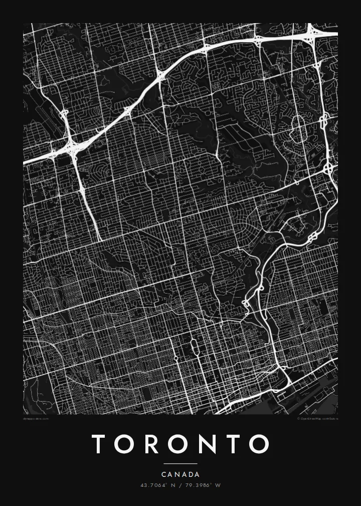
Toronto spreads along the northern shore of Lake Ontario. From above, the city is dominated by a long, regular grid. Major streets run north from the lake and cross avenues running east–west. Yonge Street, one of the city's main axes, runs north from the waterfront through the centre.
The grid is interrupted by a network of ravines. The Don Valley and the Humber River cut deep, winding green corridors through the city, carrying rivers, parks and trails. On the map they appear as long irregular strips that break up the straight lines of streets.
Offshore, the Toronto Islands form a chain of low land that shelters the inner harbour. The Gardiner Expressway and rail corridor run along the waterfront, with the CN Tower rising near the shore. A Toronto map poster shows how the lake, the grid and the ravines fit together into one clear shape.
A group of low, connected islands lies just offshore, enclosing the inner harbour. On the map they form a soft, curved edge between the city and the open lake.
The Don and Humber valleys, plus smaller ravines, cut deep green corridors through the city. They create long, irregular gaps in the street grid.
Yonge Street runs north from the lakefront through downtown and beyond. It forms a central line in Toronto's grid, with neighbourhoods arranged on both sides.
Mekem i blong yu
Putum wan dei, wan nem o wan laen blong yu, jenisim stael, saes o saed.
Fri preview i lo-resolusen mo i gat watermak. Prin mo HD file oli wok long 300 DPI, kasem 7,200 × 10,800 px, i no gat watermak.
From wanem Toronto
Toronto is a city many people move to for study or work and then call home. A map of the lake, the islands and the ravines captures the Toronto they know in a clean, simple form.
You can personalise the title, subtitle and coordinates, for example with your neighbourhood or a special date, and choose Classic black & white, Noir, Paper, Blueprint or Sand. Get it as a digital file or printed poster.
Odarem poster blong Toronto| Saes blong prent | Rezolusen | Ol fael |
|---|---|---|
| 30 × 40 cm (11.8 × 15.7″) | 3,543 × 4,724 px | PNG · PDF |
| 29.7 × 42 cm (A3, 11.7 × 16.5″) | 3,508 × 4,961 px | PNG · PDF |
| 42 × 59.4 cm (A2, 16.5 × 23.4″) | 4,961 × 7,016 px | PNG · PDF |
| 45.7 × 61 cm (18 × 24″) | 5,400 × 7,200 px | PNG · PDF |
| 50 × 70 cm (19.7 × 27.6″) | 5,906 × 8,268 px | PNG · PDF |
| 61 × 91.4 cm (24 × 36″) | 7,200 × 10,800 px | PNG · PDF |
Blong yu save komperem, fri priviu i 900 px long waed, i gat wotamak mo i blong skrin nomo. Ol HD fael oli gat kasem 8× moa rezolusen long evri saed mo oli prent klia long ful saes blong poster.
Jusum wan style antap long pej, biaen jusum Prinim Poster — wan saes mo, sapos yu wantem, wan frem — o Digital HD Files. Pemen i wan step nomo, mo pej blong oda blong yu i apdet stret taem pemen i pas.
Mifala i prinim long gudfala 200 gsm matte pepa, long wan long 6 saes, statem long 30 × 40 cm kasem 24 × 36″. Prin poster i statem long $39, sipin i insaed finis.
Yes. Jusum wan strong wud frem long kala blak, waet, natural oak, o tudak wud. I gat glas we i no save brok isi, mo i rere blong hangem stret. Poster wetem frem i statem long $99, sipin i insaed finis.
Delivri blong poster i fri long olgeta ples long wol. Wan wan poster i prin long wan long ol prin patna blong mifala we i kolosap moa long yu, long moa long 30 kantri, mo bambae i kasem yu long 3–7 wokdei. Yu save lukluk stetes mo trakin long My Orders. Sam kantri i tekem 2–5 wik, mo long ol ples we mifala i no save sendem yet, saet i talem yu bifo yu pem.
Sendem wan foto long mifala insaed 14 dei afta i kasem yu, mo mifala bae i prinim wan niufala fri o givim bak mane blong yu.
Yes. Long editor long pej ya, jenisim taetol, sabtaetol, mo laen blong koordinet i go long wanem yu wantem, mo jusum wan style mo saes. Prin, frem, mo digital oda oli yusum stret design blong yu.
Long $9 yu kasem 300 DPI PNG mo PDF file we i rere blong prinim, long evri 6 saes, i no gat watermak, mo yu save prinim long enisave ples. Yu no sua yet? Daonlodem wan fri preview wetem watermak fastaem.
Klosap
