Clear Creek corridor
The creek winds across the city at an angle to the streets. Its green corridor and trail form the most natural line in an otherwise straight-edged map.
Simpol poster blong map · United States
39.7661° N / 105.0772° W
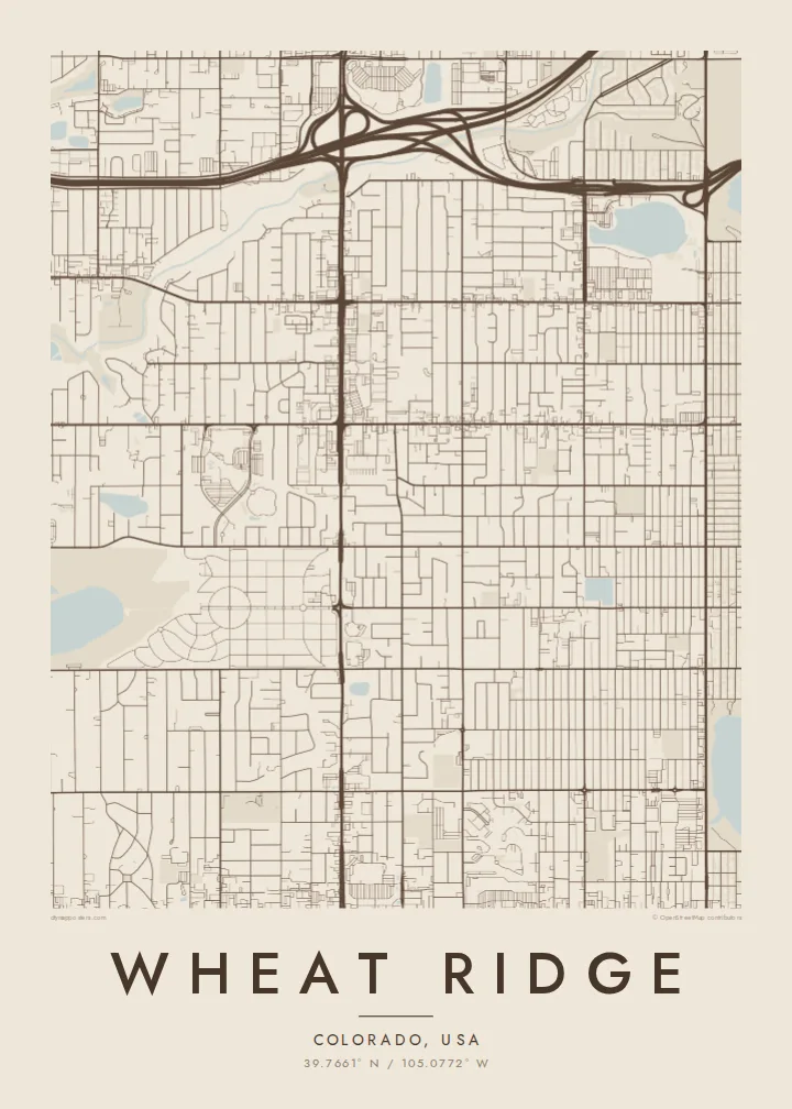
A suburban grid west of Denver, cut diagonally by Clear Creek and bordered by Interstate 70 to the north


Wan taon, faef filing
Klikim wan style blong luk hem antap long wol. Evri style i sem prais nomo — sapos yu prinim, putum insaed frem, o daonlodem olsem HD file.
 Trufala pixel · 24 × 36″ prin file
Klia blong prent
Hemia i wan 100% haf blong trufala prin file. Evri poster — sapos prinim, putum insaed frem, o daonlodem — mifala i wokem long server blong mifala long 300 DPI, kasem 7,200 × 10,800 pixel, mekem se nomata ol smol rod tu oli klia gud long wan 24 × 36″ prin.
Long wol


Map
Wheat Ridge is a city in Jefferson County, Colorado, just west of Denver. Its streets follow the same north-south and east-west grid used across the Denver metro area, with long, straight avenues at regular intervals. The Rocky Mountain foothills are not far to the west, but the city itself sits on gently sloping ground.
Clear Creek breaks the grid. It runs diagonally across the city from west to east, and a trail and green corridor follow its banks. Interstate 70 passes along the northern edge. For much of the twentieth century Wheat Ridge was known for growing carnations and called itself the Carnation City.
A Wheat Ridge map poster shows a regular suburban grid, a winding creek and a highway at the edge. That mix of straight lines and one natural curve makes it an easy map to read and to hang.
The creek winds across the city at an angle to the streets. Its green corridor and trail form the most natural line in an otherwise straight-edged map.
Arterial avenues divide the city into regular square sections. On the poster, the evenly spaced lines give the layout a clean, measured structure.
The interstate runs along the northern side of the city. Its wide lanes and interchanges form a sharp border at the top of the composition.
Mekem i blong yu
Putum wan dei, wan nem o wan laen blong yu, jenisim stael, saes o saed.
Fri preview i lo-resolusen mo i gat watermak. Prin mo HD file oli wok long 300 DPI, kasem 7,200 × 10,800 px, i no gat watermak.
From wanem Wheat Ridge
For people who have bought a house here, grew up nearby or ride the Clear Creek Trail, the map is a quiet image of the neighbourhood. It works as a housewarming gift for someone who has just moved to the west side of Denver.
Put a family name in the title, add a move-in date to the subtitle, and edit the coordinates line. Choose from Classic black & white, Noir, Paper, Blueprint and Sand.
Odarem poster blong Wheat Ridge| Saes blong prent | Rezolusen | Ol fael |
|---|---|---|
| 30 × 40 cm11.8 × 15.7″ | 3,543 × 4,724 px | PNG · PDF |
| 29.7 × 42 cm (A3)11.7 × 16.5″ | 3,508 × 4,961 px | PNG · PDF |
| 42 × 59.4 cm (A2)16.5 × 23.4″ | 4,961 × 7,016 px | PNG · PDF |
| 45.7 × 61 cm18 × 24″ | 5,400 × 7,200 px | PNG · PDF |
| 50 × 70 cm19.7 × 27.6″ | 5,906 × 8,268 px | PNG · PDF |
| 61 × 91.4 cm24 × 36″ | 7,200 × 10,800 px | PNG · PDF |
Blong yu save komperem, fri priviu i 900 px long waed, i gat wotamak mo i blong skrin nomo. Ol HD fael oli gat kasem 8× moa rezolusen long evri saed mo oli prent klia long ful saes blong poster.
Jusum wan style antap long pej, biaen jusum Prinim Poster — wan saes mo, sapos yu wantem, wan frem — o Digital HD Files. Pemen i wan step nomo, mo pej blong oda blong yu i apdet stret taem pemen i pas.
Mifala i prinim long gudfala 200 gsm matte pepa, long wan long 6 saes, statem long 30 × 40 cm kasem 24 × 36″. Prin poster i statem long $39, sipin i insaed finis.
Yes. Jusum wan strong wud frem long kala blak, waet, natural oak, o tudak wud. I gat glas we i no save brok isi, mo i rere blong hangem stret. Poster wetem frem i statem long $99, sipin i insaed finis.
Shipping i fri i go long 60+ kantri. Evri poster i kam from wan long ol prin pATna blong mifala we i stap kolosap moa long 30+ kantri, mo i save kasem yu long 3–7 wokin dei. Yu save lukluk stetus mo tracking long My Orders. Sam kantri i tekem 2–5 wik, mo long ol ples we mifala i no sendem yet, saet i talem yu bifo yu pem.
Sendem wan foto long mifala insaed 14 dei afta i kasem yu, mo mifala bae i prinim wan niufala fri o givim bak mane blong yu.
Yes. Long editor long pej ya, jenisim taetol, sabtaetol, mo laen blong koordinet i go long wanem yu wantem, mo jusum wan style mo saes. Prin, frem, mo digital oda oli yusum stret design blong yu.
Long $9 yu kasem 300 DPI PNG mo PDF file we i rere blong prinim, long evri 6 saes, i no gat watermak, mo yu save prinim long enisave ples. Yu no sua yet? Daonlodem wan fri preview wetem watermak fastaem.
Klosap
