Cliff-bound coastline
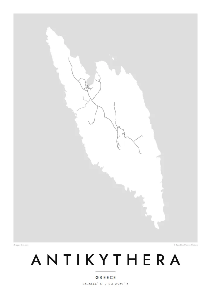
The shoreline is mostly steep rock, with only a few inlets where boats can approach. On the poster the edge of the island appears sharp and irregular, giving the landmass a clear, almost sculpted outline.
Простая картина карты · Greece
35.8644° N / 23.2989° E
A small, steep-sided island between Kythera and Crete, its rocky outline broken by a few coves and a single harbour.


Единъ градъ, пять настроенїй
Прикоснися ко образу, да узриши его на стѣнѣ. Всякъ образъ цѣну имать равну — печатанъ, обрамленъ, или яко HD файлы.
 Истинныя пиксели · печатный файлъ 24 × 36″
Остро ко печати
Сіе есть истинный отрѣзокъ настоящаго печатнаго файла, взятый на 100%. Всякъ плакатъ — печатанъ, обрамленъ, или скачанъ — образуется на серверахъ нашихъ въ 300 DPI, до 7,200 × 10,800 пикселей, да и наименьшія стези пребудутъ ясны на печати 24 × 36″.
На стѣнѣ


Карта
Antikythera sits alone in the strait between Kythera and Crete, a compact wedge of limestone with very little flat ground. From above, the island reads as a rough, elongated shape fringed by cliffs, with a handful of tracks threading between a small harbour settlement and scattered hamlets. The sea takes up most of the frame, and the land becomes a single pale form surrounded by open water.
The island is known worldwide for what was found just offshore. At the start of the twentieth century, sponge divers came across an ancient shipwreck here, and among its cargo was the Antikythera mechanism, a geared bronze device often described as the oldest known analogue computer. The object is now kept in the National Archaeological Museum in Athens, but its name will always point back to this coastline.
An Antikythera map poster is an exercise in restraint. There is no dense grid to fill the paper, only a coastline, a thin network of roads and the contour of the island against a wide field of white or black. The result is quiet and graphic, a shape that people who know the island tend to recognise at once, and that others find simply striking.
The shoreline is mostly steep rock, with only a few inlets where boats can approach. On the poster the edge of the island appears sharp and irregular, giving the landmass a clear, almost sculpted outline.
A small sheltered cove on the northern side serves as the island's port and its link to the ferries. It is where the few roads converge, which makes it the natural focal point of the map.
The waters off the island hold the wreck that yielded the famous mechanism. Nothing marks the spot on a street map, yet the empty sea around the coast carries that story for anyone who knows it.
Сотвори твое
Приложи день, имя или слово твое, премѣни видъ, мѣру или положенїе.
Безплатный образъ есть низкаго разрѣшенія со знакомъ водянымъ. Печати и HD файлы образуются въ 300 DPI, до 7,200 × 10,800 px, безъ знака водянаго.
Почто Antikythera
Antikythera appeals to people who care about the history of science, to divers and sailors, and to anyone who has made the long ferry crossing to reach it. The poster is less about streets than about one island standing alone in open sea, a small object with an outsized story.
You can add your own title and subtitle, such as the date of a visit or a line about the mechanism, and adjust the coordinates line. Choose from Classic black & white, Noir, Paper, Blueprint or Sand; Blueprint suits the scientific theme particularly well. Download HD files for $9 or order a printed poster.
Заказати плакатъ Antikythera| Мѣра печати | Ясность | Писанїя |
|---|---|---|
| 30 × 40 cm (11.8 × 15.7″) | 3,543 × 4,724 px | PNG · PDF |
| 29.7 × 42 cm (A3, 11.7 × 16.5″) | 3,508 × 4,961 px | PNG · PDF |
| 42 × 59.4 cm (A2, 16.5 × 23.4″) | 4,961 × 7,016 px | PNG · PDF |
| 45.7 × 61 cm (18 × 24″) | 5,400 × 7,200 px | PNG · PDF |
| 50 × 70 cm (19.7 × 27.6″) | 5,906 × 8,268 px | PNG · PDF |
| 61 × 91.4 cm (24 × 36″) | 7,200 × 10,800 px | PNG · PDF |
Ко сравненїю: безмездный образъ имать 900 px въ ширину, со водянымъ знаменїемъ, и ко зрѣнїю на экранѣ. HD-писанїя имутъ до 8× большую ясность во всякую страну и печатаются чисто во полную мѣру картины.
Избери образъ въ началѣ страницы, потомъ избери Печатный Плакатъ — величину и, аще хощеши, рамку — или Цифровыя HD Файлы. Оплата совершается во единъ шагъ, и страница заказа твоего обновляется, егда платежъ пройдетъ.
Печатается на первосортной матовой бумазѣ 200 gsm во единой изъ шести величинъ, отъ 30 × 40 cm до 24 × 36″. Печатные плакаты начинаются отъ $39, съ доставкою включенною.
Да. Избери рамку изъ цѣльнаго древа — черную, бѣлую, изъ природнаго дуба, или изъ темнаго древа. Пріидетъ съ стекломъ неразбиваемымъ, готова ко повѣшенію. Обрамленные плакаты начинаются отъ $99, съ доставкою включенною.
Доставка по всемꙋ мирꙋ безмѣздна. Всякъ плакатъ печатаетсѧ блиѕъ сꙋщѧ ѿ печатникъ нашихъ въ 30+ странахъ и обычно приходитъ въ 3–7 дньхъ дѣлатєльныхъ. Състоѧнїе и стезю посылки видѣти можеши въ «Моихъ заказѣхъ». Въ нѣкоторыхъ странахъ 2–5 сєдмицъ, а аще мѣсто то еще не посылаемъ, сїй сайтъ повѣстъ ти прежде платежа.
Пошли намъ фотографію въ теченіе 14 дней отъ доставки, и мы напечатаемъ его снова безплатно, или возвратимъ ти цѣну.
Да. Во редакторѣ на сей страницѣ измѣни заглавіе, подзаглавіе и строку координатъ на еже хощеши, и избери образъ и величину. Печатные, обрамленные и цифровые заказы вси употребляютъ точно твое начертаніе.
За $9 пріемлеши файлы PNG во 300 DPI и файлы PDF, готовыя ко печати, во всѣхъ шести величинахъ, безъ знака водянаго, да печатаеши идѣже хощеши. Еще не увѣренъ? Скачай прежде безплатный образъ со знакомъ водянымъ.
