Suomenlinna sea fortress
Built in the eighteenth century across several linked islands at the harbour entrance, its angular bastions and irregular walls form one of the most distinctive outlines on the whole map.
Простая картина карты · Finland
60.1695° N / 24.9354° E
A granite peninsula that breaks into bays and islands, with a compact grid at its tip and sea on three sides


Единъ градъ, пять настроенїй
Прикоснися ко образу, да узриши его на стѣнѣ. Всякъ образъ цѣну имать равну — печатанъ, обрамленъ, или яко HD файлы.
 Истинныя пиксели · печатный файлъ 24 × 36″
Остро ко печати
Сіе есть истинный отрѣзокъ настоящаго печатнаго файла, взятый на 100%. Всякъ плакатъ — печатанъ, обрамленъ, или скачанъ — образуется на серверахъ нашихъ въ 300 DPI, до 7,200 × 10,800 пикселей, да и наименьшія стези пребудутъ ясны на печати 24 × 36″.
На стѣнѣ


Карта
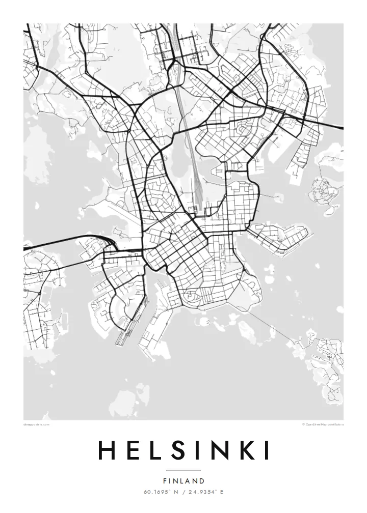
Helsinki sits on a peninsula that pushes into the Gulf of Finland, and from above its coastline matters most. The land breaks into coves, headlands and more than three hundred islands, so the city carries on past the point where the streets stop. Inland the pattern loosens into leafy districts and a long strip of forest, the Central Park, which runs north almost unbroken from Töölö Bay towards the city's edge.
The centre is orderly. After Helsinki was named capital in 1812, the architect Carl Ludvig Engel laid out a neoclassical core around Senate Square. The Esplanadi park strip still runs west from the market harbour as straight as a ruler. Around it, blocks of stone apartment buildings form a tight grid that reads cleanly in black and white. Rail yards and the long curve of the harbour break it up.
A Helsinki map poster shows this balance of order and irregularity: a precise centre, a coastline with almost no straight lines, and water in every gap. Offshore, the island fortress of Suomenlinna, a UNESCO World Heritage Site, spreads across a cluster of connected islets at the harbour mouth. Ferries, bridges and causeways join the rest together, and each one leaves a thin line on the page.
Built in the eighteenth century across several linked islands at the harbour entrance, its angular bastions and irregular walls form one of the most distinctive outlines on the whole map.
Senate Square and the Esplanadi park avenue sit just back from the South Harbour. They give the densest streets a clear, symmetrical anchor that stands out at every print size.
A band of forest about ten kilometres long runs north from the inner city. It leaves a wide, pale ribbon between the residential districts on either side.
Сотвори твое
Приложи день, имя или слово твое, премѣни видъ, мѣру или положенїе.
Безплатный образъ есть низкаго разрѣшенія со знакомъ водянымъ. Печати и HD файлы образуются въ 300 DPI, до 7,200 × 10,800 px, безъ знака водянаго.
Почто Helsinki
People hang Helsinki for a flat near Töölö, summers on the islands, or an exchange year that turned into something longer. The map holds all of it at once: the harbour, the grid and the sea. Add a title, a date or a line of coordinates to mark which chapter it belongs to.
The coastline works especially well in Noir, where the water turns dark and the islands look like scattered light, or in Blueprint for a cooler, technical look. Classic black & white, Paper and Sand are available too. Download the HD files for $9 or order a matte print, framed if you like.
Заказати плакатъ Helsinki| Мѣра печати | Ясность | Писанїя |
|---|---|---|
| 30 × 40 cm (11.8 × 15.7″) | 3,543 × 4,724 px | PNG · PDF |
| 29.7 × 42 cm (A3, 11.7 × 16.5″) | 3,508 × 4,961 px | PNG · PDF |
| 42 × 59.4 cm (A2, 16.5 × 23.4″) | 4,961 × 7,016 px | PNG · PDF |
| 45.7 × 61 cm (18 × 24″) | 5,400 × 7,200 px | PNG · PDF |
| 50 × 70 cm (19.7 × 27.6″) | 5,906 × 8,268 px | PNG · PDF |
| 61 × 91.4 cm (24 × 36″) | 7,200 × 10,800 px | PNG · PDF |
Ко сравненїю: безмездный образъ имать 900 px въ ширину, со водянымъ знаменїемъ, и ко зрѣнїю на экранѣ. HD-писанїя имутъ до 8× большую ясность во всякую страну и печатаются чисто во полную мѣру картины.
Избери образъ въ началѣ страницы, потомъ избери Печатный Плакатъ — величину и, аще хощеши, рамку — или Цифровыя HD Файлы. Оплата совершается во единъ шагъ, и страница заказа твоего обновляется, егда платежъ пройдетъ.
Печатается на первосортной матовой бумазѣ 200 gsm во единой изъ шести величинъ, отъ 30 × 40 cm до 24 × 36″. Печатные плакаты начинаются отъ {printFrom}, съ доставкою включенною.
Да. Избери рамку изъ цѣльнаго древа — черную, бѣлую, изъ природнаго дуба, или изъ темнаго древа. Пріидетъ съ стекломъ неразбиваемымъ, готова ко повѣшенію. Обрамленные плакаты начинаются отъ {framedFrom}, съ доставкою включенною.
Доставка по всемꙋ мирꙋ безмѣздна. Всякъ плакатъ печатаетсѧ блиѕъ сꙋщѧ ѿ печатникъ нашихъ въ 30+ странахъ и обычно приходитъ въ 3–7 дньхъ дѣлатєльныхъ. Състоѧнїе и стезю посылки видѣти можеши въ «Моихъ заказѣхъ». Въ нѣкоторыхъ странахъ 2–5 сєдмицъ, а аще мѣсто то еще не посылаемъ, сїй сайтъ повѣстъ ти прежде платежа.
Пошли намъ фотографію въ теченіе 14 дней отъ доставки, и мы напечатаемъ его снова безплатно, или возвратимъ ти цѣну.
Да. Во редакторѣ на сей страницѣ измѣни заглавіе, подзаглавіе и строку координатъ на еже хощеши, и избери образъ и величину. Печатные, обрамленные и цифровые заказы вси употребляютъ точно твое начертаніе.
За $9 пріемлеши файлы PNG во 300 DPI и файлы PDF, готовыя ко печати, во всѣхъ шести величинахъ, безъ знака водянаго, да печатаеши идѣже хощеши. Еще не увѣренъ? Скачай прежде безплатный образъ со знакомъ водянымъ.
