Misumi West Port
A carefully engineered Meiji-era harbour of cut stone, with canals and quays, lies near the tip of the peninsula. It is one of the few ports of its era to survive largely intact.
Простая картина карты · Japan
32.6222° N / 130.6618° E
A coastal city at the root of the Uto Peninsula, facing two inland seas with a Meiji-era stone port at its western tip.

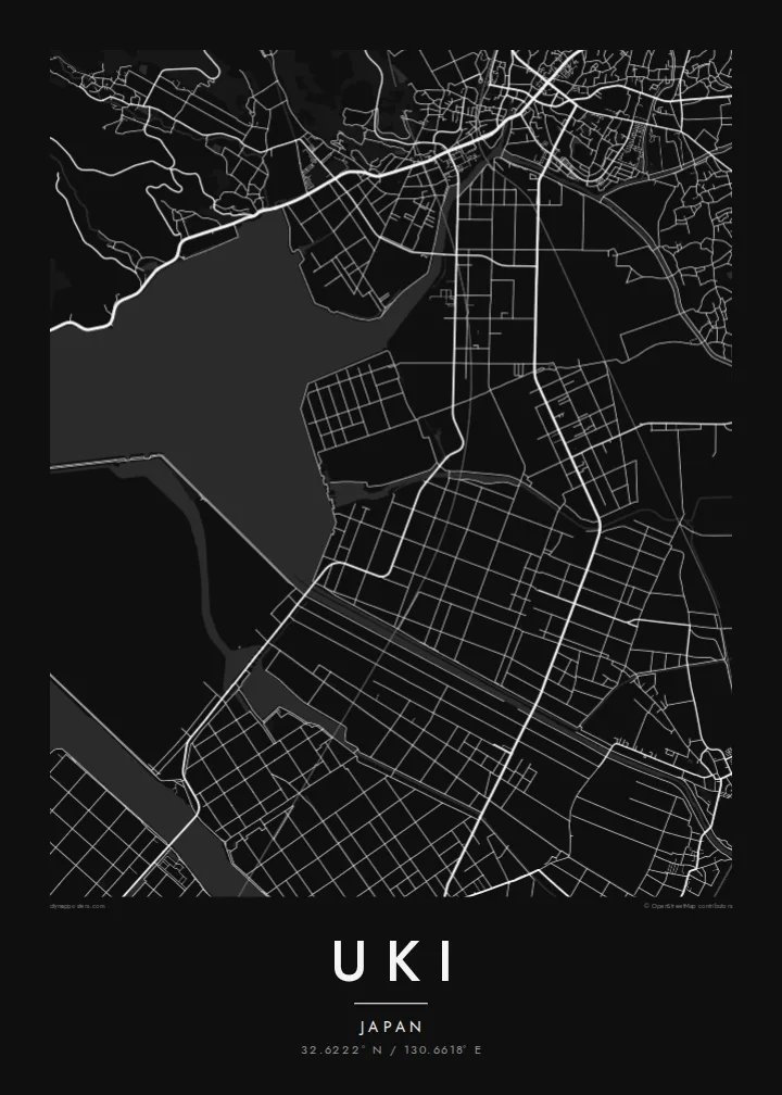


Единъ градъ, пять настроенїй
Прикоснися ко образу, да узриши его на стѣнѣ. Всякъ образъ цѣну имать равну — печатанъ, обрамленъ, или яко HD файлы.
 Истинныя пиксели · печатный файлъ 24 × 36″
Остро ко печати
Сіе есть истинный отрѣзокъ настоящаго печатнаго файла, взятый на 100%. Всякъ плакатъ — печатанъ, обрамленъ, или скачанъ — образуется на серверахъ нашихъ въ 300 DPI, до 7,200 × 10,800 пикселей, да и наименьшія стези пребудутъ ясны на печати 24 × 36″.
На стѣнѣ


Карта
Uki sits in Kumamoto Prefecture at the base of the Uto Peninsula, which reaches west toward the Amakusa islands. On a map the city stretches along the peninsula. The Ariake Sea lies to the north and the Yatsushiro Sea to the south, and small towns and fishing harbours are strung along both shores. Hills run down the centre of the peninsula, with farmland and orchards on their lower slopes.
At the western end lies Misumi West Port, a stone harbour built in the late nineteenth century to Dutch designs. It is now a UNESCO World Heritage site as part of the Sites of Japan's Meiji Industrial Revolution. The Yatsushiro Sea off Uki's coast is also associated with the shiranui, a rare optical phenomenon of flickering lights on the water described in local tradition.
A Uki map poster traces a long, narrow city defined by its shorelines. Coastal roads follow the edge of the land, while a railway runs out along the peninsula toward the port. Smaller settlements appear as clusters where valleys meet the sea. The water surrounding almost every side gives the map a strong, clean silhouette.
A carefully engineered Meiji-era harbour of cut stone, with canals and quays, lies near the tip of the peninsula. It is one of the few ports of its era to survive largely intact.
The Ariake Sea and the Yatsushiro Sea border the city on opposite sides. On the map the peninsula becomes a long strip of land between two open bodies of water.
Hills run along the centre of the peninsula, with roads and small valleys branching toward the coasts. This inland ridge divides the city's northern and southern shores.
Сотвори твое
Приложи день, имя или слово твое, премѣни видъ, мѣру или положенїе.
Безплатный образъ есть низкаго разрѣшенія со знакомъ водянымъ. Печати и HD файлы образуются въ 300 DPI, до 7,200 × 10,800 px, безъ знака водянаго.
Почто Uki
Uki is a place of coastal drives, fishing harbours and evenings looking across the water toward Amakusa. A map of the peninsula keeps that geography in view for residents, for visitors and for anyone with family roots in Kumamoto.
Choose Classic black & white, Noir, Paper, Blueprint or Sand, and add your own title, subtitle and coordinates. The free preview lets you check the framing first. HD files cost $9, and printed posters can ship from partners in more than 30 countries.
Заказати плакатъ Uki| Мѣра печати | Ясность | Писанїя |
|---|---|---|
| 30 × 40 cm (11.8 × 15.7″) | 3,543 × 4,724 px | PNG · PDF |
| 29.7 × 42 cm (A3, 11.7 × 16.5″) | 3,508 × 4,961 px | PNG · PDF |
| 42 × 59.4 cm (A2, 16.5 × 23.4″) | 4,961 × 7,016 px | PNG · PDF |
| 45.7 × 61 cm (18 × 24″) | 5,400 × 7,200 px | PNG · PDF |
| 50 × 70 cm (19.7 × 27.6″) | 5,906 × 8,268 px | PNG · PDF |
| 61 × 91.4 cm (24 × 36″) | 7,200 × 10,800 px | PNG · PDF |
Ко сравненїю: безмездный образъ имать 900 px въ ширину, со водянымъ знаменїемъ, и ко зрѣнїю на экранѣ. HD-писанїя имутъ до 8× большую ясность во всякую страну и печатаются чисто во полную мѣру картины.
Избери образъ въ началѣ страницы, потомъ избери Печатный Плакатъ — величину и, аще хощеши, рамку — или Цифровыя HD Файлы. Оплата совершается во единъ шагъ, и страница заказа твоего обновляется, егда платежъ пройдетъ.
Печатается на первосортной матовой бумазѣ 200 gsm во единой изъ шести величинъ, отъ 30 × 40 cm до 24 × 36″. Печатные плакаты начинаются отъ {printFrom}, съ доставкою включенною.
Да. Избери рамку изъ цѣльнаго древа — черную, бѣлую, изъ природнаго дуба, или изъ темнаго древа. Пріидетъ съ стекломъ неразбиваемымъ, готова ко повѣшенію. Обрамленные плакаты начинаются отъ {framedFrom}, съ доставкою включенною.
Доставка безплатна по всему міру. Всякъ плакатъ печатается ближайшимъ изъ печатныхъ другъ нашихъ во 30+ странахъ, и обычно достизаетъ во 3–7 дней дѣловыхъ. Можеши слѣдити за состояніемъ и путемъ его во Заказахъ Моихъ.
Пошли намъ фотографію въ теченіе 14 дней отъ доставки, и мы напечатаемъ его снова безплатно, или возвратимъ ти цѣну.
Да. Во редакторѣ на сей страницѣ измѣни заглавіе, подзаглавіе и строку координатъ на еже хощеши, и избери образъ и величину. Печатные, обрамленные и цифровые заказы вси употребляютъ точно твое начертаніе.
За $9 пріемлеши файлы PNG во 300 DPI и файлы PDF, готовыя ко печати, во всѣхъ шести величинахъ, безъ знака водянаго, да печатаеши идѣже хощеши. Еще не увѣренъ? Скачай прежде безплатный образъ со знакомъ водянымъ.
