The Karun River
Iran's longest river runs past the town as it comes out of the Zagros. Its meanders and the farmland along its banks give the composition its strongest line.
བཟོ་རྣམ་འཇམ་ཏོང་ས་ཁྲའི་པོས་ཊར · ཨི་རཱན
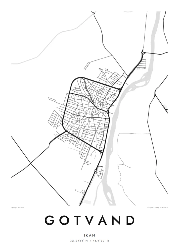
32.2458° N / 48.8132° E
A compact Khuzestan town beside the Karun River, where the plain begins to rise toward the Zagros foothills


ཁྲོམ་གཅིག་ སེམས་ཁམས་ལྔ།
སྟའེལ་ཅིག་ལུ་ཨེབ་གཏང་འབད་ནི་ཨིནམ་ད་ཕྱག་ཤོག་གུར་ག་དེ་སྦེ་མཐོང་ནི་ཨིན་ན་བལྟ། སྟའེལ་ག་ར་གི་གོང་ཚད་གཅིག་མཚུངས་ཨིན། པར་བསྐྲུན་འབད་ཡོད་མི་དང་སྒམ་བཙུགས་ཡོད་མི་ནམ་ HD ཡིག་སྣོད་ཚུ་ཨིན་རུང་མཐུན་ཨིན།
 དངོས་སུའི་ pixels · 24 × 36″ པར་བསྐྲུན་ཡིག་སྣོད
དཔར་ནིའི་གསལ་ཚད།
འདི་དངོས་སུའི་པར་བསྐྲུན་ཡིག་སྣོད་ཀྱི་ ༡༠༠% ཁ་སྐོང་ཨིན། པར་བསྐྲུན་འབད་ཡོད་མི་དང་སྒམ་བཙུགས་ཡོད་མི་དང་ཕབ་ལེན་འབད་ཡོད་མི་ཕྱག་ཤོག་ག་ར་ང་བཅུད་ Server ལུ་ 300 DPI ནང་7,200 × 10,800 pixels་ཚུན་བཟོ་བཏོན་འབདཝ་ཨིནམ་ལས་ལམ་གནམ་མེད་ས་མེད་ཆུང་ཀུའི་ལམ་ཚུ་ཡང་ 24 × 36″ པར་བསྐྲུན་གུར་གསལ་བཏུབ་ཨིན།
རྩིག་པའི་གུར


ས་ཁྲ།
Gotvand sits in northern Khuzestan, where the flat farmland of southwestern Iran starts to fold into the first ridges of the Zagros. From above, the town is a small, dense cluster of streets on the plain. Irrigated fields and the line of the Karun River frame it, and the river is the feature that sets the direction of the whole map.
The Karun is Iran's longest river, and near Gotvand it leaves the mountains for the lowlands. Upstream, the Upper Gotvand Dam holds back one of the country's large reservoirs. Built for hydropower and water storage, it has been debated for years over salt deposits in the reservoir area. That puts the town at a point where a major river meets major engineering.
A Gotvand map poster keeps things plain: the grid of residential lanes, the roads heading out toward Shushtar and the dam, and the river's curve set against empty space. In black and white, the contrast between the settled plain and the rougher ground to the north comes through clearly. The result is a quiet, readable picture of a town shaped by water.
Iran's longest river runs past the town as it comes out of the Zagros. Its meanders and the farmland along its banks give the composition its strongest line.
North of the town, a large rockfill dam turns the Karun into a long reservoir. It is one of the best-known water projects in Khuzestan.
South of Gotvand the land lies flat and farmed. To the north the relief starts to break into ridges, so the map shows two landscapes meeting.
ཁྱོད་རའི་དོན་ལུ་བཟོ།
ཚེས་གྲངས་ མིང་ ཡང་ན་ ཁྱོད་རའི་ཚིག་ཐིག་ཅིག་བཙུགས། བཟོ་རྣམ་ ཚད་ ཡང་ན་ ཁ་ཕྱོགས་སོར།
རིན་མེད་ preview འདི་གྲངས་ཐིག་དམའ་ཞིང་ཡིག་རྟགས་དང་བཅས་ཨིན། པར་བསྐྲུན་དང་ HD ཡིག་སྣོད་ཚུ་ 300 DPI ནང་7,200 × 10,800 px་ཚུན་ཡིག་རྟགས་མེད་པར་བཟོ་བཏོན་འབདཝ་ཨིན།
ག་ཅི་འབད་ Gotvand
People who grew up in Gotvand, or whose families farmed along the Karun, often want something that shows home as it actually lies on the land. This map does that simply, with the river, the fields and the town between them.
You can set the title, subtitle and coordinates line to mark a family name, a year or the exact spot of a house. Then pick one of five styles: Classic black & white, Noir, Paper, Blueprint or Sand.
Gotvand ཕྱག་ཤོག་བཙུགས་བཏབ| དཔར་ཚད། | གསལ་ཚད། | ཡིག་སྣོད། |
|---|---|---|
| 30 × 40 cm (11.8 × 15.7″) | 3,543 × 4,724 px | PNG · PDF |
| 29.7 × 42 cm (A3, 11.7 × 16.5″) | 3,508 × 4,961 px | PNG · PDF |
| 42 × 59.4 cm (A2, 16.5 × 23.4″) | 4,961 × 7,016 px | PNG · PDF |
| 45.7 × 61 cm (18 × 24″) | 5,400 × 7,200 px | PNG · PDF |
| 50 × 70 cm (19.7 × 27.6″) | 5,906 × 8,268 px | PNG · PDF |
| 61 × 91.4 cm (24 × 36″) | 7,200 × 10,800 px | PNG · PDF |
ག་བསྡུར་འབད་བ་ཅིན་ རིན་མེད་སྔོན་ལྟ་འདི་ རྒྱ་ཚད་ 900 px ཡོདཔ་དང་ ཆུ་རྟགས་ཡོད་པའི་ གསལ་གཞི་ནང་བལྟ་ནིའི་དོན་ལུ་ཨིན། HD ཡིག་སྣོད་ཚུ་ ཁ་ཕྱོགས་རེ་རེ་ནང་ གསལ་ཚད་ 8× ཚུན་ཡོདཔ་ལས་ པོས་ཊར་ཚད་ཆ་ཚང་ནང་ གསལ་ཏོག་ཏོ་སྦེ་དཔར་ཚུགས།
ཤོག་ལེབ་གུར་སྟའེལ་ཅིག་སེལ་འཐུ་འབད་བའི་ཤུལ་ལས་ Printed Poster (ཚད་ཅིག་དང་དགོ་པ་ཅིན་སྒམ་ཅིག) ཡང་ན་ Digital HD Files སེལ་འཐུ་འབད། Checkout ལུ་གནས་སྐབས་གཅིག་རྐྱང་དགོཔ་ཨིནམ་ད་སྤྲོད་ལེན་ལེགས་ཤོམ་བྱུང་མ་ཐག་ ཁྱོད་རའི་བཙུགས་བཏབ་ཤོག་ལེབ་གསར་བཅོས་འབད་འོང་།
འདི་ 200 gsm matte ཤོག་བུ་ཡག་ཤོས་གུར་ 30 × 40 cm ལས་ 24 × 36″ ཚུན་ཚད་དྲུག་གི་ནང་ལས་གཅིག་ནང་པར་བསྐྲུན་འབདཝ་ཨིན། པར་བསྐྲུན་ཕྱག་ཤོག་ཚུ་ $39 ལས་འགོ་བཙུགསཔ་ཨིནམ་ད་འགྲེམ་སྤེལ་ཡང་ཚུད་ཡོདཔ་ཨིན།
བཏུབ་ཨིན། ཤིང་གི་སྒམ་ཚོས་གདོང་ནག་པོ་ཡང་ན་དཀར་པོ་ ཡང་ན་ oak ཐོན་ཁུངས་ ཡང་ན་ ཤིང་ནག་ཅིག་སེལ་འཐུ་འབད། འདི་ཤེལ་མི་བོར་མི་ཤོག་ཐང་དང་བཅས་བརྟེན་འོངམ་ཨིནམ་ད་ཨེབ་ནི་ལུ་གྲ་སྒྲིག་ཡོད། སྒམ་བཙུགས་ཡོད་མི་ཕྱག་ཤོག་ཚུ་ $99 ལས་འགོ་བཙུགསཔ་ཨིནམ་ད་འགྲེམ་སྤེལ་ཡང་ཚུད་ཡོདཔ་ཨིན།
འཛམ་གླིང་ཡོངས་ལུ་སྐྱེལ་སྲོལ་མི་དགོ། པོསི་ཊར་རེ་རེ་འདི་ རྒྱལ་ཁབ་ ༣༠ ལས་ལྷག་པའི་ ང་བཅོས་པར་འདེབས་མཁོ་ཚོགས་ཀྱི་ཉེ་ཤོས་ཅིག་གིས་པར་བཏབ་སྟེ་ སྤྱིར་བཏང་ལས་ཀྱི་ཉིན་མ་ ༣–༧ ནང་འབྱོར་ཚུགས། གནས་སྟངས་དང་རྗེས་འདེད་འདི་ "ངེ་གི་ཨོར་ཌར་" ནང་བལྟ་ཚུགས། རྒྱལ་ཁབ་ཁ་གཅིག་ལུ་ བདུན་ཕྲག་ ༢–༥ གི་ནང་འབྱོར་ཡི། ད་ལྟོ་ཡང་སྐྱེལ་མ་ཚུགས་པའི་ས་ཁོངས་ལུ་ གླ་འཐུས་མ་བཏང་གོང་ལུ་ དྲྭ་ཚིགས་ཀྱིས་ཁྱོད་ལུ་གསལ་བཀོད་བྱེ།
ཐོབ་ཤུལ་ཉིན་གྲངས་ 14 གྱི་ནང་འཁོད་པར་ཅིག་བཏང་ ང་བཅས་ཀྱིས་རིན་མེད་ཐོག་ལས་སླར་པར་བསྐྲུན་འབད་འོང་ ཡང་ན་སོང་ཡོད་མི་སྤྲོད་འོང་།
བཏུབ་ཨིན། ཤོག་ལེབ་འདི་གུར་ Editor ནང་མགོ་མིང་དང་མགོ་མིང་འོག་མ་དེ་ལས་ལོངས་ཚད་ཡིག་ཐིག་དེ་ག་ཅི་འབད་ཡང་བསྒྱུར་བཅོས་འབད་དེ་སྟའེལ་དང་ཚད་ཅིག་སེལ་འཐུ་འབད། པར་བསྐྲུན་དང་སྒམ་བཙུགས་དང་ digital བཙུགས་བཏབ་ཚུ་ག་ར་ཁྱོད་རའི་བཟོ་རྣམ་དེ་རྐྱངམ་ཅིག་བེད་སྤྱོད་འབད་འོང་།
$9 ཐོག་ལས་ 300 DPI PNG དང་པར་བསྐྲུན་ལུ་གྲ་སྒྲིག་འབད་ཡོད་མི་ PDF ཡིག་སྣོད་ཚུ་ཚད་དྲུག་ཆ་མཉམ་ ཡིག་རྟགས་མེད་པར་ཐོབ་ནི་ཨིནམ་ད་གནས་ག་ཏེ་ལུ་ཡང་པར་བསྐྲུན་འབད་བཏུབ། ང་བཅས་ལུ་ཡིད་ཆེས་མེད་པ་ཅིན་ཡིག་རྟགས་ཡོད་མི་ rin med preview ཅིག་ཧེ་མ་ཕབ་ལེན་འབད་བལྟ།
ཉེ་འདབས།
