Lake-strewn land
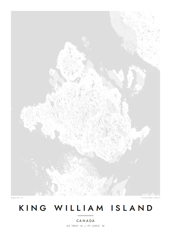
Thousands of small lakes cover the flat interior. They give the map a dense, dotted texture unlike most island outlines.
བཟོ་རྣམ་འཇམ་ཏོང་ས་ཁྲའི་པོས་ཊར · ཀེ་ན་ཌ
69.1800° N / 97.3506° W
A flat Arctic island scattered with lakes, in the channels where the Franklin expedition was lost


ཁྲོམ་གཅིག་ སེམས་ཁམས་ལྔ།
སྟའེལ་ཅིག་ལུ་ཨེབ་གཏང་འབད་ནི་ཨིནམ་ད་ཕྱག་ཤོག་གུར་ག་དེ་སྦེ་མཐོང་ནི་ཨིན་ན་བལྟ། སྟའེལ་ག་ར་གི་གོང་ཚད་གཅིག་མཚུངས་ཨིན། པར་བསྐྲུན་འབད་ཡོད་མི་དང་སྒམ་བཙུགས་ཡོད་མི་ནམ་ HD ཡིག་སྣོད་ཚུ་ཨིན་རུང་མཐུན་ཨིན།
 དངོས་སུའི་ pixels · 24 × 36″ པར་བསྐྲུན་ཡིག་སྣོད
དཔར་ནིའི་གསལ་ཚད།
འདི་དངོས་སུའི་པར་བསྐྲུན་ཡིག་སྣོད་ཀྱི་ ༡༠༠% ཁ་སྐོང་ཨིན། པར་བསྐྲུན་འབད་ཡོད་མི་དང་སྒམ་བཙུགས་ཡོད་མི་དང་ཕབ་ལེན་འབད་ཡོད་མི་ཕྱག་ཤོག་ག་ར་ང་བཅུད་ Server ལུ་ 300 DPI ནང་7,200 × 10,800 pixels་ཚུན་བཟོ་བཏོན་འབདཝ་ཨིནམ་ལས་ལམ་གནམ་མེད་ས་མེད་ཆུང་ཀུའི་ལམ་ཚུ་ཡང་ 24 × 36″ པར་བསྐྲུན་གུར་གསལ་བཏུབ་ཨིན།
རྩིག་པའི་གུར


ས་ཁྲ།
King William Island lies in the Kitikmeot Region of Nunavut, in the Canadian Arctic. From above it is a broad, low island. The terrain is almost level, and the landscape is dotted with countless lakes and ponds left by glaciation, so the map looks finely speckled with water.
The only community is Gjoa Haven, on the southeastern coast. It takes its name from the Gjøa, the ship in which Roald Amundsen spent two winters in the harbour in the early 1900s while searching for the Northwest Passage. Inuit taught him skills that helped his expedition succeed.
The waters around the island are where Sir John Franklin's 1840s expedition was lost. The wrecks of HMS Erebus and HMS Terror were found nearby in 2014 and 2016. A King William Island map poster sets this history against a quiet pattern of lakes and shoreline.
Thousands of small lakes cover the flat interior. They give the map a dense, dotted texture unlike most island outlines.
The single settlement sits beside a sheltered harbour on the southeast coast, a small cluster of streets on an otherwise open island.
Narrow channels separate the island from the mainland and neighbouring islands. These are the passages at the heart of the Northwest Passage story.
ཁྱོད་རའི་དོན་ལུ་བཟོ།
ཚེས་གྲངས་ མིང་ ཡང་ན་ ཁྱོད་རའི་ཚིག་ཐིག་ཅིག་བཙུགས། བཟོ་རྣམ་ ཚད་ ཡང་ན་ ཁ་ཕྱོགས་སོར།
རིན་མེད་ preview འདི་གྲངས་ཐིག་དམའ་ཞིང་ཡིག་རྟགས་དང་བཅས་ཨིན། པར་བསྐྲུན་དང་ HD ཡིག་སྣོད་ཚུ་ 300 DPI ནང་7,200 × 10,800 px་ཚུན་ཡིག་རྟགས་མེད་པར་བཟོ་བཏོན་འབདཝ་ཨིན།
ག་ཅི་འབད་ King William Island
For people from Gjoa Haven, and for anyone who has followed the Franklin search or the Northwest Passage, this map carries real meaning. Its lake pattern is also striking as pure design.
Add your own title, subtitle and coordinates line, such as a family name, a year or a place. Choose Classic black & white, Noir, Paper, Blueprint or Sand.
King William Island ཕྱག་ཤོག་བཙུགས་བཏབ| དཔར་ཚད། | གསལ་ཚད། | ཡིག་སྣོད། |
|---|---|---|
| 30 × 40 cm11.8 × 15.7″ | 3,543 × 4,724 px | PNG · PDF |
| 29.7 × 42 cm (A3)11.7 × 16.5″ | 3,508 × 4,961 px | PNG · PDF |
| 42 × 59.4 cm (A2)16.5 × 23.4″ | 4,961 × 7,016 px | PNG · PDF |
| 45.7 × 61 cm18 × 24″ | 5,400 × 7,200 px | PNG · PDF |
| 50 × 70 cm19.7 × 27.6″ | 5,906 × 8,268 px | PNG · PDF |
| 61 × 91.4 cm24 × 36″ | 7,200 × 10,800 px | PNG · PDF |
ག་བསྡུར་འབད་བ་ཅིན་ རིན་མེད་སྔོན་ལྟ་འདི་ རྒྱ་ཚད་ 900 px ཡོདཔ་དང་ ཆུ་རྟགས་ཡོད་པའི་ གསལ་གཞི་ནང་བལྟ་ནིའི་དོན་ལུ་ཨིན། HD ཡིག་སྣོད་ཚུ་ ཁ་ཕྱོགས་རེ་རེ་ནང་ གསལ་ཚད་ 8× ཚུན་ཡོདཔ་ལས་ པོས་ཊར་ཚད་ཆ་ཚང་ནང་ གསལ་ཏོག་ཏོ་སྦེ་དཔར་ཚུགས།
ཤོག་ལེབ་གུར་སྟའེལ་ཅིག་སེལ་འཐུ་འབད་བའི་ཤུལ་ལས་ Printed Poster (ཚད་ཅིག་དང་དགོ་པ་ཅིན་སྒམ་ཅིག) ཡང་ན་ Digital HD Files སེལ་འཐུ་འབད། Checkout ལུ་གནས་སྐབས་གཅིག་རྐྱང་དགོཔ་ཨིནམ་ད་སྤྲོད་ལེན་ལེགས་ཤོམ་བྱུང་མ་ཐག་ ཁྱོད་རའི་བཙུགས་བཏབ་ཤོག་ལེབ་གསར་བཅོས་འབད་འོང་།
འདི་ 200 gsm matte ཤོག་བུ་ཡག་ཤོས་གུར་ 30 × 40 cm ལས་ 24 × 36″ ཚུན་ཚད་དྲུག་གི་ནང་ལས་གཅིག་ནང་པར་བསྐྲུན་འབདཝ་ཨིན། པར་བསྐྲུན་ཕྱག་ཤོག་ཚུ་ $39 ལས་འགོ་བཙུགསཔ་ཨིནམ་ད་འགྲེམ་སྤེལ་ཡང་ཚུད་ཡོདཔ་ཨིན།
བཏུབ་ཨིན། ཤིང་གི་སྒམ་ཚོས་གདོང་ནག་པོ་ཡང་ན་དཀར་པོ་ ཡང་ན་ oak ཐོན་ཁུངས་ ཡང་ན་ ཤིང་ནག་ཅིག་སེལ་འཐུ་འབད། འདི་ཤེལ་མི་བོར་མི་ཤོག་ཐང་དང་བཅས་བརྟེན་འོངམ་ཨིནམ་ད་ཨེབ་ནི་ལུ་གྲ་སྒྲིག་ཡོད། སྒམ་བཙུགས་ཡོད་མི་ཕྱག་ཤོག་ཚུ་ $99 ལས་འགོ་བཙུགསཔ་ཨིནམ་ད་འགྲེམ་སྤེལ་ཡང་ཚུད་ཡོདཔ་ཨིན།
རྒྱལ་ཁབ་ ༦༠+ ལུ་ སྐྱེལ་འདྲེན་ཁེ་མེད་ཨིན། པོ་སི་ཊར་ག་ར་ རྒྱལ་ཁབ་ ༣༠+ ནང་ལྷོད་པའི་ ང་བཅས་ཀྱི་ པར་འདེབས་མཉམ་གཅིག་པ་ཚུ་ ནང་ལས་ ཉེ་ཤོས་གཅིག་གིས་ པར་བཏབ་སྟེ་ སྤྱིར་བཏང་ལུ་ ལས་ཀའི་ཉིནམ་ ༣–༧ ནང་ལྷོད་ནི་ཨིན། གནས་སྟངས་དང་ རྗེས་འདེད་ཚུ་ “ངེའི་ཨོ་ཌར་” ནང་ལས་ བལྟ་ཚུགས། རྒྱལ་ཁབ་ལ་ལུ་ བདུན་ཕྲག་ ༢–༥ ཅིག་ འགོ་ནི་ཨིན། ད་ལྟོ་ཡང་ སྐྱེལ་མི་བཏུབ་པའི་ས་ཁོངས་ལུ་ དངུལ་སྤྲོད་མ་འབད་བའི་ཧེ་མར་ དྲ་ཚིགས་ཀྱིས་ ཁྱོད་ལུ་ གསལ་བཤད་འབདཝ་ཨིན།
ཐོབ་ཤུལ་ཉིན་གྲངས་ 14 གྱི་ནང་འཁོད་པར་ཅིག་བཏང་ ང་བཅས་ཀྱིས་རིན་མེད་ཐོག་ལས་སླར་པར་བསྐྲུན་འབད་འོང་ ཡང་ན་སོང་ཡོད་མི་སྤྲོད་འོང་།
བཏུབ་ཨིན། ཤོག་ལེབ་འདི་གུར་ Editor ནང་མགོ་མིང་དང་མགོ་མིང་འོག་མ་དེ་ལས་ལོངས་ཚད་ཡིག་ཐིག་དེ་ག་ཅི་འབད་ཡང་བསྒྱུར་བཅོས་འབད་དེ་སྟའེལ་དང་ཚད་ཅིག་སེལ་འཐུ་འབད། པར་བསྐྲུན་དང་སྒམ་བཙུགས་དང་ digital བཙུགས་བཏབ་ཚུ་ག་ར་ཁྱོད་རའི་བཟོ་རྣམ་དེ་རྐྱངམ་ཅིག་བེད་སྤྱོད་འབད་འོང་།
$9 ཐོག་ལས་ 300 DPI PNG དང་པར་བསྐྲུན་ལུ་གྲ་སྒྲིག་འབད་ཡོད་མི་ PDF ཡིག་སྣོད་ཚུ་ཚད་དྲུག་ཆ་མཉམ་ ཡིག་རྟགས་མེད་པར་ཐོབ་ནི་ཨིནམ་ད་གནས་ག་ཏེ་ལུ་ཡང་པར་བསྐྲུན་འབད་བཏུབ། ང་བཅས་ལུ་ཡིད་ཆེས་མེད་པ་ཅིན་ཡིག་རྟགས་ཡོད་མི་ rin med preview ཅིག་ཧེ་མ་ཕབ་ལེན་འབད་བལྟ།
ཉེ་འདབས།
