East coast centre
Lakatoro and Norsup, on the east coast, form the island's main hub. Their streets and roads are the densest part of the map, set against the surrounding forest.
བཟོ་རྣམ་འཇམ་ཏོང་ས་ཁྲའི་པོས་ཊར · ཝ་ནུ་ཨ་ཏུ
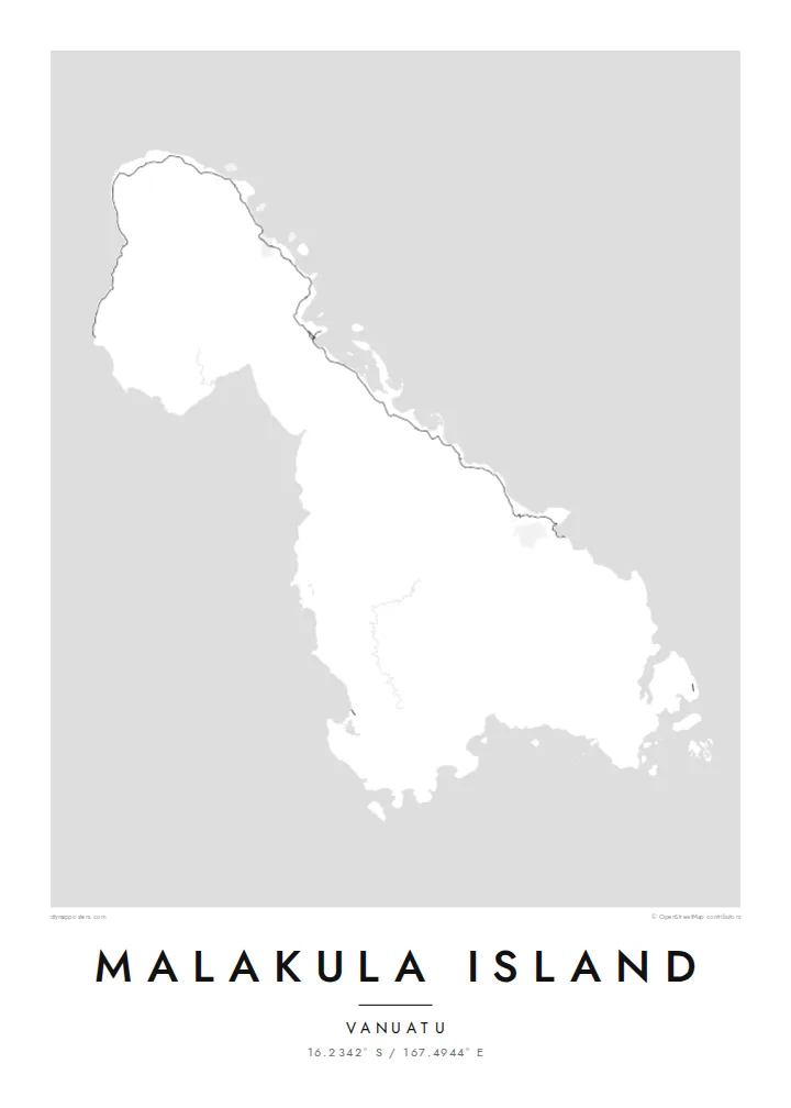
16.2342° S / 167.4944° E
Vanuatu's second-largest island, an irregular landmass of forested hills with small island groups scattered off its coasts.


ཁྲོམ་གཅིག་ སེམས་ཁམས་ལྔ།
སྟའེལ་ཅིག་ལུ་ཨེབ་གཏང་འབད་ནི་ཨིནམ་ད་ཕྱག་ཤོག་གུར་ག་དེ་སྦེ་མཐོང་ནི་ཨིན་ན་བལྟ། སྟའེལ་ག་ར་གི་གོང་ཚད་གཅིག་མཚུངས་ཨིན། པར་བསྐྲུན་འབད་ཡོད་མི་དང་སྒམ་བཙུགས་ཡོད་མི་ནམ་ HD ཡིག་སྣོད་ཚུ་ཨིན་རུང་མཐུན་ཨིན།
 དངོས་སུའི་ pixels · 24 × 36″ པར་བསྐྲུན་ཡིག་སྣོད
དཔར་ནིའི་གསལ་ཚད།
འདི་དངོས་སུའི་པར་བསྐྲུན་ཡིག་སྣོད་ཀྱི་ ༡༠༠% ཁ་སྐོང་ཨིན། པར་བསྐྲུན་འབད་ཡོད་མི་དང་སྒམ་བཙུགས་ཡོད་མི་དང་ཕབ་ལེན་འབད་ཡོད་མི་ཕྱག་ཤོག་ག་ར་ང་བཅུད་ Server ལུ་ 300 DPI ནང་7,200 × 10,800 pixels་ཚུན་བཟོ་བཏོན་འབདཝ་ཨིནམ་ལས་ལམ་གནམ་མེད་ས་མེད་ཆུང་ཀུའི་ལམ་ཚུ་ཡང་ 24 × 36″ པར་བསྐྲུན་གུར་གསལ་བཏུབ་ཨིན།
རྩིག་པའི་གུར


ས་ཁྲ།
Malakula, also spelled Malekula, is the second-largest island in Vanuatu, in the South Pacific. Its outline is irregular, with a broad main body, a coastline cut by bays and headlands, and small islands and island groups scattered close offshore. The Maskelyne Islands lie off the southeastern tip. The interior is hilly and forested, and it is crossed by only a few roads.
The island is known for its remarkable cultural and linguistic diversity. A large number of distinct languages are spoken on Malakula, a notable concentration even by the standards of Vanuatu. It is also associated with the Big Nambas and Small Nambas, well-known cultural groups. The provincial centre, Lakatoro, and the nearby airstrip at Norsup lie on the east coast.
A Malakula Island map poster balances coastline and open ground. A road runs along parts of the coast, linking villages, and the east coast holds the densest clusters. The rest of the interior remains largely empty, where the forested hills rise. Offshore, the small islands add a lively scatter of shapes around the main body of the island.
Lakatoro and Norsup, on the east coast, form the island's main hub. Their streets and roads are the densest part of the map, set against the surrounding forest.
Small islands, including the Maskelyne group near the southeastern tip, lie close to Malakula's coast. They add a scatter of small shapes around the main outline.
The hilly interior has very few roads. On the map it leaves a broad open area inside the coastline, underlining how much of the island is rugged and wild.
ཁྱོད་རའི་དོན་ལུ་བཟོ།
ཚེས་གྲངས་ མིང་ ཡང་ན་ ཁྱོད་རའི་ཚིག་ཐིག་ཅིག་བཙུགས། བཟོ་རྣམ་ ཚད་ ཡང་ན་ ཁ་ཕྱོགས་སོར།
རིན་མེད་ preview འདི་གྲངས་ཐིག་དམའ་ཞིང་ཡིག་རྟགས་དང་བཅས་ཨིན། པར་བསྐྲུན་དང་ HD ཡིག་སྣོད་ཚུ་ 300 DPI ནང་7,200 × 10,800 px་ཚུན་ཡིག་རྟགས་མེད་པར་བཟོ་བཏོན་འབདཝ་ཨིན།
ག་ཅི་འབད་ Malakula Island
Malakula means a great deal to its many communities and to those who have lived, taught or travelled there. Its irregular outline and scattered offshore islands make a distinctive print, well suited to someone whose connection to Vanuatu runs deep.
Add your own title and subtitle, such as a village or a year, and edit the coordinates line. Pick from Classic black & white, Noir, Paper, Blueprint and Sand. Get the $9 HD files in six print sizes, or order a printed poster shipped from partners in more than 30 countries.
Malakula Island ཕྱག་ཤོག་བཙུགས་བཏབ| དཔར་ཚད། | གསལ་ཚད། | ཡིག་སྣོད། |
|---|---|---|
| 30 × 40 cm11.8 × 15.7″ | 3,543 × 4,724 px | PNG · PDF |
| 29.7 × 42 cm (A3)11.7 × 16.5″ | 3,508 × 4,961 px | PNG · PDF |
| 42 × 59.4 cm (A2)16.5 × 23.4″ | 4,961 × 7,016 px | PNG · PDF |
| 45.7 × 61 cm18 × 24″ | 5,400 × 7,200 px | PNG · PDF |
| 50 × 70 cm19.7 × 27.6″ | 5,906 × 8,268 px | PNG · PDF |
| 61 × 91.4 cm24 × 36″ | 7,200 × 10,800 px | PNG · PDF |
ག་བསྡུར་འབད་བ་ཅིན་ རིན་མེད་སྔོན་ལྟ་འདི་ རྒྱ་ཚད་ 900 px ཡོདཔ་དང་ ཆུ་རྟགས་ཡོད་པའི་ གསལ་གཞི་ནང་བལྟ་ནིའི་དོན་ལུ་ཨིན། HD ཡིག་སྣོད་ཚུ་ ཁ་ཕྱོགས་རེ་རེ་ནང་ གསལ་ཚད་ 8× ཚུན་ཡོདཔ་ལས་ པོས་ཊར་ཚད་ཆ་ཚང་ནང་ གསལ་ཏོག་ཏོ་སྦེ་དཔར་ཚུགས།
ཤོག་ལེབ་གུར་སྟའེལ་ཅིག་སེལ་འཐུ་འབད་བའི་ཤུལ་ལས་ Printed Poster (ཚད་ཅིག་དང་དགོ་པ་ཅིན་སྒམ་ཅིག) ཡང་ན་ Digital HD Files སེལ་འཐུ་འབད། Checkout ལུ་གནས་སྐབས་གཅིག་རྐྱང་དགོཔ་ཨིནམ་ད་སྤྲོད་ལེན་ལེགས་ཤོམ་བྱུང་མ་ཐག་ ཁྱོད་རའི་བཙུགས་བཏབ་ཤོག་ལེབ་གསར་བཅོས་འབད་འོང་།
འདི་ 200 gsm matte ཤོག་བུ་ཡག་ཤོས་གུར་ 30 × 40 cm ལས་ 24 × 36″ ཚུན་ཚད་དྲུག་གི་ནང་ལས་གཅིག་ནང་པར་བསྐྲུན་འབདཝ་ཨིན། པར་བསྐྲུན་ཕྱག་ཤོག་ཚུ་ $39 ལས་འགོ་བཙུགསཔ་ཨིནམ་ད་འགྲེམ་སྤེལ་ཡང་ཚུད་ཡོདཔ་ཨིན།
བཏུབ་ཨིན། ཤིང་གི་སྒམ་ཚོས་གདོང་ནག་པོ་ཡང་ན་དཀར་པོ་ ཡང་ན་ oak ཐོན་ཁུངས་ ཡང་ན་ ཤིང་ནག་ཅིག་སེལ་འཐུ་འབད། འདི་ཤེལ་མི་བོར་མི་ཤོག་ཐང་དང་བཅས་བརྟེན་འོངམ་ཨིནམ་ད་ཨེབ་ནི་ལུ་གྲ་སྒྲིག་ཡོད། སྒམ་བཙུགས་ཡོད་མི་ཕྱག་ཤོག་ཚུ་ $99 ལས་འགོ་བཙུགསཔ་ཨིནམ་ད་འགྲེམ་སྤེལ་ཡང་ཚུད་ཡོདཔ་ཨིན།
རྒྱལ་ཁབ་ ༦༠+ ལུ་ སྐྱེལ་འདྲེན་ཁེ་མེད་ཨིན། པོ་སི་ཊར་ག་ར་ རྒྱལ་ཁབ་ ༣༠+ ནང་ལྷོད་པའི་ ང་བཅས་ཀྱི་ པར་འདེབས་མཉམ་གཅིག་པ་ཚུ་ ནང་ལས་ ཉེ་ཤོས་གཅིག་གིས་ པར་བཏབ་སྟེ་ སྤྱིར་བཏང་ལུ་ ལས་ཀའི་ཉིནམ་ ༣–༧ ནང་ལྷོད་ནི་ཨིན། གནས་སྟངས་དང་ རྗེས་འདེད་ཚུ་ “ངེའི་ཨོ་ཌར་” ནང་ལས་ བལྟ་ཚུགས། རྒྱལ་ཁབ་ལ་ལུ་ བདུན་ཕྲག་ ༢–༥ ཅིག་ འགོ་ནི་ཨིན། ད་ལྟོ་ཡང་ སྐྱེལ་མི་བཏུབ་པའི་ས་ཁོངས་ལུ་ དངུལ་སྤྲོད་མ་འབད་བའི་ཧེ་མར་ དྲ་ཚིགས་ཀྱིས་ ཁྱོད་ལུ་ གསལ་བཤད་འབདཝ་ཨིན།
ཐོབ་ཤུལ་ཉིན་གྲངས་ 14 གྱི་ནང་འཁོད་པར་ཅིག་བཏང་ ང་བཅས་ཀྱིས་རིན་མེད་ཐོག་ལས་སླར་པར་བསྐྲུན་འབད་འོང་ ཡང་ན་སོང་ཡོད་མི་སྤྲོད་འོང་།
བཏུབ་ཨིན། ཤོག་ལེབ་འདི་གུར་ Editor ནང་མགོ་མིང་དང་མགོ་མིང་འོག་མ་དེ་ལས་ལོངས་ཚད་ཡིག་ཐིག་དེ་ག་ཅི་འབད་ཡང་བསྒྱུར་བཅོས་འབད་དེ་སྟའེལ་དང་ཚད་ཅིག་སེལ་འཐུ་འབད། པར་བསྐྲུན་དང་སྒམ་བཙུགས་དང་ digital བཙུགས་བཏབ་ཚུ་ག་ར་ཁྱོད་རའི་བཟོ་རྣམ་དེ་རྐྱངམ་ཅིག་བེད་སྤྱོད་འབད་འོང་།
$9 ཐོག་ལས་ 300 DPI PNG དང་པར་བསྐྲུན་ལུ་གྲ་སྒྲིག་འབད་ཡོད་མི་ PDF ཡིག་སྣོད་ཚུ་ཚད་དྲུག་ཆ་མཉམ་ ཡིག་རྟགས་མེད་པར་ཐོབ་ནི་ཨིནམ་ད་གནས་ག་ཏེ་ལུ་ཡང་པར་བསྐྲུན་འབད་བཏུབ། ང་བཅས་ལུ་ཡིད་ཆེས་མེད་པ་ཅིན་ཡིག་རྟགས་ཡོད་མི་ rin med preview ཅིག་ཧེ་མ་ཕབ་ལེན་འབད་བལྟ།
ཉེ་འདབས།
