Northern settlements
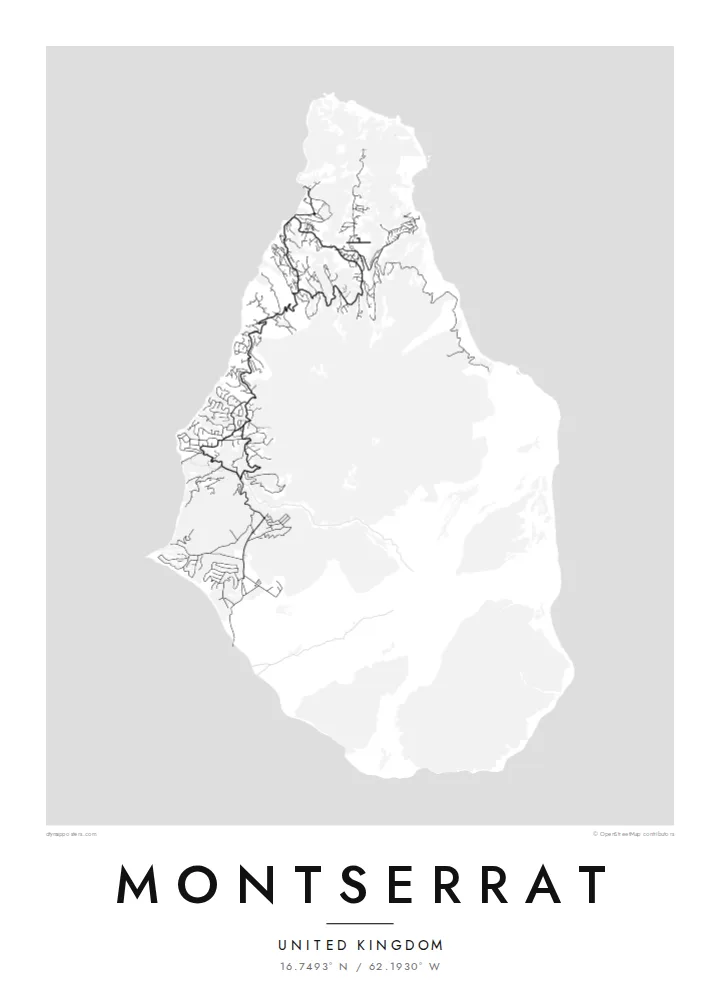
Brades, Little Bay and the surrounding villages gather most of the island's roads in the north, where winding lanes follow the ridges and valleys of the Silver and Centre Hills.
Μινιμαλιστική αφίσα χάρτη · Ηνωμένο Βασίλειο
16.7493° N / 62.1930° W
A small, pear-shaped Caribbean island whose green northern hills hold the towns while the volcanic south lies closed.


Μία πόλη, πέντε διαθέσεις
Πατήστε ένα στιλ για να το δείτε στον τοίχο. Κάθε στιλ κοστίζει το ίδιο — τυπωμένο, με κορνίζα ή ως αρχεία HD.
 Πραγματικά pixel · αρχείο εκτύπωσης 24 × 36″
Ευκρίνεια εκτύπωσης
Αυτό είναι απόσπασμα 100% από το πραγματικό αρχείο εκτύπωσης. Κάθε αφίσα — τυπωμένη, με κορνίζα ή σε ψηφιακή μορφή — αποδίδεται στους διακομιστές μας στα 300 DPI, έως 7,200 × 10,800 pixel, ώστε ακόμη και οι πιο λεπτές λεπτομέρειες να παραμένουν ευκρινείς σε εκτύπωση 24 × 36″.
Στον τοίχο


Ο χάρτης
Montserrat is a British Overseas Territory in the Leeward Islands, around sixteen kilometres from north to south. Its shape narrows toward the north, and three groups of hills run down its length: the Silver Hills at the northern tip, the forested Centre Hills in the middle and the Soufrière Hills in the south. It has long been called the Emerald Isle of the Caribbean, partly for its Irish heritage.
Since 1995 the Soufrière Hills volcano has reshaped the island. Eruptions buried the former capital, Plymouth, and much of the south became an exclusion zone. A Montserrat map poster therefore shows an unusual pattern: roads and villages concentrated in the north, around Brades and Little Bay, and a southern half where the streets of the abandoned capital sit cut off from the rest of the network.
Life on the island moved north after the eruptions, and a new airport, new housing and a small port were built there. The volcano is still monitored closely, and the landscape around it continues to change with each period of activity. The result on paper is a map that records both an island and a recent turn in its history.
Brades, Little Bay and the surrounding villages gather most of the island's roads in the north, where winding lanes follow the ridges and valleys of the Silver and Centre Hills.
The volcano dominates the southern half, its slopes left largely without roads. On the poster this area reads as open ground, a clear graphic contrast with the settled north.
The former capital on the southwest coast was abandoned after the 1997 eruptions. Its street pattern still shows on the map, isolated inside the exclusion zone.
Κάν' την δική σου
Πρόσθεσε μια ημερομηνία, ένα όνομα ή μια δική σου φράση, άλλαξε στιλ, μέγεθος ή προσανατολισμό.
Η δωρεάν προεπισκόπηση είναι χαμηλής ανάλυσης με υδατογράφημα. Οι εκτυπώσεις και τα αρχεία HD αποδίδονται στα 300 DPI, έως 7,200 × 10,800 px, χωρίς υδατογράφημα.
Γιατί Montserrat
People with family ties to Montserrat, and those who knew it before 1995, often want a map that shows the whole island rather than only its settled part. The compact outline fits comfortably on any of the print sizes and keeps its detail.
The title, subtitle and coordinates line can all be changed, so the poster might carry a family village or a year that matters. Pick one of five styles, Classic, Noir, Paper, Blueprint or Sand, then download 300 DPI files for $9 or order a printed poster with an optional wooden frame.
Παραγγείλετε την αφίσα Montserrat| Μέγεθος εκτύπωσης | Ανάλυση | Αρχεία |
|---|---|---|
| 30 × 40 cm11.8 × 15.7″ | 3,543 × 4,724 px | PNG · PDF |
| 29.7 × 42 cm (A3)11.7 × 16.5″ | 3,508 × 4,961 px | PNG · PDF |
| 42 × 59.4 cm (A2)16.5 × 23.4″ | 4,961 × 7,016 px | PNG · PDF |
| 45.7 × 61 cm18 × 24″ | 5,400 × 7,200 px | PNG · PDF |
| 50 × 70 cm19.7 × 27.6″ | 5,906 × 8,268 px | PNG · PDF |
| 61 × 91.4 cm24 × 36″ | 7,200 × 10,800 px | PNG · PDF |
Για σύγκριση, η δωρεάν προεπισκόπηση έχει πλάτος 900 px, φέρει υδατογράφημα και προορίζεται για οθόνες. Τα αρχεία HD έχουν έως 8× μεγαλύτερη ανάλυση σε κάθε διάσταση και τυπώνονται καθαρά σε πλήρες μέγεθος αφίσας.
Επιλέξτε ένα στιλ στο πάνω μέρος της σελίδας και μετά διαλέξτε Τυπωμένη Αφίσα — μέγεθος και, αν θέλετε, κορνίζα — ή Ψηφιακά Αρχεία HD. Η ολοκλήρωση παραγγελίας γίνεται σε ένα βήμα και η σελίδα παραγγελίας σας ενημερώνεται μόλις ολοκληρωθεί η πληρωμή.
Τυπώνεται σε premium ματ χαρτί 200 gsm σε ένα από έξι μεγέθη, από 30 × 40 cm έως 24 × 36″. Οι τυπωμένες αφίσες ξεκινούν από $39, με τα μεταφορικά συμπεριλαμβανόμενα.
Ναι. Επιλέξτε μασίφ ξύλινη κορνίζα σε μαύρο, λευκό, φυσική βελανιδιά ή σκούρο ξύλο. Έρχεται με άθραυστο τζάμι και είναι έτοιμη για ανάρτηση. Οι αφίσες με κορνίζα ξεκινούν από $99, με τα μεταφορικά συμπεριλαμβανόμενα.
Η αποστολή είναι δωρεάν σε 60+ χώρες. Κάθε αφίσα τυπώνεται από τον πλησιέστερο συνεργάτη εκτύπωσης μας, σε 30+ χώρες, και συνήθως φτάνει σε 3–7 εργάσιμες ημέρες. Μπορείτε να παρακολουθείτε την κατάσταση και την αποστολή στις Παραγγελίες μου. Σε μερικές χώρες χρειάζονται 2–5 εβδομάδες, και όπου δεν στέλνουμε ακόμη, το site σάς ενημερώνει πριν πληρώσετε.
Στείλτε μας μια φωτογραφία εντός 14 ημερών από την παράδοση και θα την τυπώσουμε ξανά δωρεάν ή θα σας επιστρέψουμε τα χρήματα.
Ναι. Στον επεξεργαστή σε αυτή τη σελίδα, αλλάξτε τον τίτλο, τον υπότιτλο και τη γραμμή συντεταγμένων όπως θέλετε, και επιλέξτε στιλ και μέγεθος. Οι τυπωμένες, με κορνίζα και ψηφιακές παραγγελίες χρησιμοποιούν ακριβώς το δικό σας σχέδιο.
Για $9 λαμβάνετε αρχεία PNG στα 300 DPI και έτοιμα για εκτύπωση PDF και στα έξι μεγέθη, χωρίς υδατογράφημα, για εκτύπωση οπουδήποτε. Δεν είστε ακόμη σίγουροι; Κατεβάστε πρώτα μια δωρεάν προεπισκόπηση με υδατογράφημα.
