Strait of Magellan
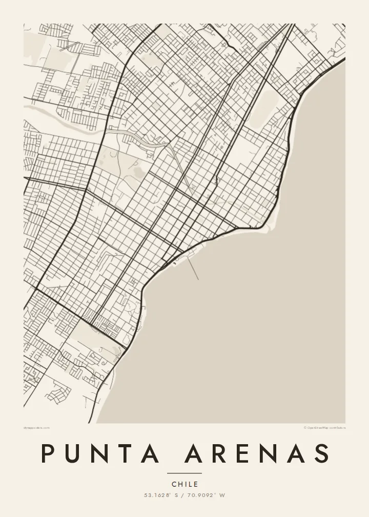
The city's whole eastern side faces the strait. On the poster it appears as a broad open plane, with the city running along one shore and Tierra del Fuego across the water.
Μινιμαλιστική αφίσα χάρτη · Χιλή
53.1628° S / 70.9092° W
A windswept grid on the Strait of Magellan, where straight streets run down to the water facing Tierra del Fuego




Μία πόλη, πέντε διαθέσεις
Πατήστε ένα στιλ για να το δείτε στον τοίχο. Κάθε στιλ κοστίζει το ίδιο — τυπωμένο, με κορνίζα ή ως αρχεία HD.
 Πραγματικά pixel · αρχείο εκτύπωσης 24 × 36″
Ευκρίνεια εκτύπωσης
Αυτό είναι απόσπασμα 100% από το πραγματικό αρχείο εκτύπωσης. Κάθε αφίσα — τυπωμένη, με κορνίζα ή σε ψηφιακή μορφή — αποδίδεται στους διακομιστές μας στα 300 DPI, έως 7,200 × 10,800 pixel, ώστε ακόμη και οι πιο λεπτές λεπτομέρειες να παραμένουν ευκρινείς σε εκτύπωση 24 × 36″.
Στον τοίχο


Ο χάρτης
Punta Arenas stretches along the western shore of the Strait of Magellan and is one of the southernmost cities in the world. From above, it is a disciplined grid of straight streets and square blocks. The grid runs from the coastline up gentle slopes toward the hills and the Patagonian steppe. The Costanera road follows the shore, and to the east lies the open water of the strait, with Tierra del Fuego on the far side.
The city was founded in 1848 as a Chilean outpost. It prospered as a port on the route between the Atlantic and Pacific before the Panama Canal opened, and later as a centre of the sheep-farming trade. Its central square, Plaza Muñoz Gamero, is laid out around a monument to Magellan. A Punta Arenas map poster shows the plaza at the heart of a regular plan that seems built to hold firm against the wind.
In black and white, the contrast between land and sea is stark. The dense grid stops at a clean coastline, and the strait fills the rest of the frame as a single calm field. Small rivers and ravines come down from the hills and break into the rows of blocks. The result is a graphic image of a city at the edge of the continent.
The city's whole eastern side faces the strait. On the poster it appears as a broad open plane, with the city running along one shore and Tierra del Fuego across the water.
The main square sits at the centre of the grid, surrounded by regular blocks. The Magellan monument stands there, and the square is the anchor of the whole plan.
Straight streets climb from the coast toward the western hills in long parallel rows. They give the city its orderly, almost drafted look against the open landscape.
Κάν' την δική σου
Πρόσθεσε μια ημερομηνία, ένα όνομα ή μια δική σου φράση, άλλαξε στιλ, μέγεθος ή προσανατολισμό.
Η δωρεάν προεπισκόπηση είναι χαμηλής ανάλυσης με υδατογράφημα. Οι εκτυπώσεις και τα αρχεία HD αποδίδονται στα 300 DPI, έως 7,200 × 10,800 px, χωρίς υδατογράφημα.
Γιατί Punta Arenas
Punta Arenas is often a gateway to Torres del Paine, Antarctic voyages and Tierra del Fuego, so its map works as a keepsake of a journey to the far south. For residents, it is a striking portrait of a city defined by its coastline.
You can personalise the title, subtitle and coordinates line, for example with an expedition date or a family name. Choose from five styles: Classic black & white, Noir, Paper, Blueprint and Sand. Blueprint suits the seafaring history of the port. Order it as a digital file or as a printed poster.
Παραγγείλετε την αφίσα Punta Arenas| Μέγεθος εκτύπωσης | Ανάλυση | Αρχεία |
|---|---|---|
| 30 × 40 cm11.8 × 15.7″ | 3,543 × 4,724 px | PNG · PDF |
| 29.7 × 42 cm (A3)11.7 × 16.5″ | 3,508 × 4,961 px | PNG · PDF |
| 42 × 59.4 cm (A2)16.5 × 23.4″ | 4,961 × 7,016 px | PNG · PDF |
| 45.7 × 61 cm18 × 24″ | 5,400 × 7,200 px | PNG · PDF |
| 50 × 70 cm19.7 × 27.6″ | 5,906 × 8,268 px | PNG · PDF |
| 61 × 91.4 cm24 × 36″ | 7,200 × 10,800 px | PNG · PDF |
Για σύγκριση, η δωρεάν προεπισκόπηση έχει πλάτος 900 px, φέρει υδατογράφημα και προορίζεται για οθόνες. Τα αρχεία HD έχουν έως 8× μεγαλύτερη ανάλυση σε κάθε διάσταση και τυπώνονται καθαρά σε πλήρες μέγεθος αφίσας.
Επιλέξτε ένα στιλ στο πάνω μέρος της σελίδας και μετά διαλέξτε Τυπωμένη Αφίσα — μέγεθος και, αν θέλετε, κορνίζα — ή Ψηφιακά Αρχεία HD. Η ολοκλήρωση παραγγελίας γίνεται σε ένα βήμα και η σελίδα παραγγελίας σας ενημερώνεται μόλις ολοκληρωθεί η πληρωμή.
Τυπώνεται σε premium ματ χαρτί 200 gsm σε ένα από έξι μεγέθη, από 30 × 40 cm έως 24 × 36″. Οι τυπωμένες αφίσες ξεκινούν από $39, με τα μεταφορικά συμπεριλαμβανόμενα.
Ναι. Επιλέξτε μασίφ ξύλινη κορνίζα σε μαύρο, λευκό, φυσική βελανιδιά ή σκούρο ξύλο. Έρχεται με άθραυστο τζάμι και είναι έτοιμη για ανάρτηση. Οι αφίσες με κορνίζα ξεκινούν από $99, με τα μεταφορικά συμπεριλαμβανόμενα.
Η αποστολή είναι δωρεάν σε 60+ χώρες. Κάθε αφίσα τυπώνεται από τον πλησιέστερο συνεργάτη εκτύπωσης μας, σε 30+ χώρες, και συνήθως φτάνει σε 3–7 εργάσιμες ημέρες. Μπορείτε να παρακολουθείτε την κατάσταση και την αποστολή στις Παραγγελίες μου. Σε μερικές χώρες χρειάζονται 2–5 εβδομάδες, και όπου δεν στέλνουμε ακόμη, το site σάς ενημερώνει πριν πληρώσετε.
Στείλτε μας μια φωτογραφία εντός 14 ημερών από την παράδοση και θα την τυπώσουμε ξανά δωρεάν ή θα σας επιστρέψουμε τα χρήματα.
Ναι. Στον επεξεργαστή σε αυτή τη σελίδα, αλλάξτε τον τίτλο, τον υπότιτλο και τη γραμμή συντεταγμένων όπως θέλετε, και επιλέξτε στιλ και μέγεθος. Οι τυπωμένες, με κορνίζα και ψηφιακές παραγγελίες χρησιμοποιούν ακριβώς το δικό σας σχέδιο.
Για $9 λαμβάνετε αρχεία PNG στα 300 DPI και έτοιμα για εκτύπωση PDF και στα έξι μεγέθη, χωρίς υδατογράφημα, για εκτύπωση οπουδήποτε. Δεν είστε ακόμη σίγουροι; Κατεβάστε πρώτα μια δωρεάν προεπισκόπηση με υδατογράφημα.
Κοντά
