Central street grid
The core follows a regular grid of rectangular blocks, a layout common to Guatemalan towns. On paper it forms a steady, even texture at the centre of the composition.
Minimalistinen karttajuliste · Guatemala
14.3010° N / 90.7882° W
A lowland grid on Guatemala's Pacific slope, strung along the highway that runs from the volcanoes down to the coast



Yksi kaupunki, viisi tunnelmaa
Napauta tyyliä nähdäksesi sen seinällä. Kaikki tyylit maksavat saman verran — painettuna, kehystettynä tai HD-tiedostoina.
 Todelliset pikselit · 24 × 36″ tulostustiedosto
Terävä painojälki
Tämä on 100 %:n rajaus todellisesta tulostustiedostosta. Jokainen juliste — painettu, kehystetty tai ladattu — renderöidään palvelimillamme 300 DPI:n tarkkuudella, jopa 7,200 × 10,800 pikseliin asti, joten pienimmätkin kadut pysyvät terävinä 24 × 36″ -tulosteessa.
Seinällä


Kartta
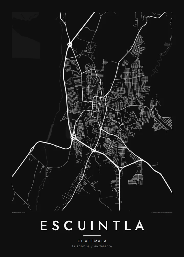
Escuintla lies south of Guatemala City, where the highlands drop into the hot Pacific coastal plain. The city is the capital of the department of the same name. From above it is a fairly regular grid of blocks, cut through by the main highway that links the capital with the Pacific ports. Beyond the edges, the grid gives way to large agricultural estates.
The surrounding lowlands are among the country's most productive farmland, with sugar cane covering much of the plain. To the north the land rises towards the volcanic chain that includes Agua, Fuego and Pacaya. The city sits at the transition between the steep volcanic slopes and the flat coast.
An Escuintla map poster captures this crossroads position. Straight blocks make an even pattern at the centre, while arterial roads leave the grid at angles, heading towards the mountains and the sea. In monochrome, the density of streets and the openness of the surrounding plain are both easy to read.
The core follows a regular grid of rectangular blocks, a layout common to Guatemalan towns. On paper it forms a steady, even texture at the centre of the composition.
The main route between Guatemala City and the Pacific coast runs past the city. It makes a long, confident line that shows Escuintla's role as a stop between highlands and sea.
Beyond the last streets the map opens into broad, sparsely drawn farmland. This gives the dense urban grid a clear outline and plenty of breathing space.
Tee siitä omasi
Lisää päivämäärä, nimi tai oma tekstisi, vaihda tyyliä, kokoa tai suuntaa.
Ilmainen esikatselu on matalaresoluutioinen ja vesileimattu. Painetut julisteet ja HD-tiedostot renderöidään 300 DPI:n tarkkuudella, jopa 7,200 × 10,800 px asti, ilman vesileimaa.
Miksi Escuintla
For anyone with roots in the Pacific lowlands, or who has passed through on the road to the coast, Escuintla's grid is a familiar shape. The poster turns that everyday geography into a quiet piece for a wall.
Add a personal title, a subtitle such as a date or a family name, and your own coordinates line. Then pick Classic black & white, Noir, Paper, Blueprint or Sand to set the mood.
Tilaa Escuintla-juliste| Tulostekoko | Resoluutio | Tiedostot |
|---|---|---|
| 30 × 40 cm (11.8 × 15.7″) | 3,543 × 4,724 px | PNG · PDF |
| 29.7 × 42 cm (A3, 11.7 × 16.5″) | 3,508 × 4,961 px | PNG · PDF |
| 42 × 59.4 cm (A2, 16.5 × 23.4″) | 4,961 × 7,016 px | PNG · PDF |
| 45.7 × 61 cm (18 × 24″) | 5,400 × 7,200 px | PNG · PDF |
| 50 × 70 cm (19.7 × 27.6″) | 5,906 × 8,268 px | PNG · PDF |
| 61 × 91.4 cm (24 × 36″) | 7,200 × 10,800 px | PNG · PDF |
Vertailun vuoksi: ilmainen esikatselu on 900 px leveä, vesileimattu ja tarkoitettu näytöille. HD-tiedostojen resoluutio on jopa 8-kertainen kumpaankin suuntaan, ja ne tulostuvat siististi täydessä julistekoossa.
Valitse tyyli sivun yläosasta ja sen jälkeen Painettu juliste — koko ja halutessasi kehys — tai Digitaaliset HD-tiedostot. Kassalla on vain yksi vaihe, ja tilaussivusi päivittyy heti maksun jälkeen.
Se painetaan laadukkaalle 200 g/m² mattapaperille kuudessa eri koossa, 30 × 40 cm:stä 24 × 36″:een. Painetut julisteet alkaen {printFrom}, toimitus sisältyy hintaan.
Kyllä. Valitse massiivipuinen kehys mustana, valkoisena, luonnontammena tai tummana puuna. Kehykseen kuuluu iskunkestävä lasitus, ja se on heti ripustusvalmis. Kehystetyt julisteet alkaen {framedFrom}, toimitus sisältyy hintaan.
Toimitus on ilmainen kaikkialle maailmaan. Jokainen juliste painetaan lähimmän tulostuskumppanimme luona yli 30 maassa ja saapuu yleensä 3–7 arkipäivässä. Voit seurata tilaustasi ja seurantatietoja kohdasta Omat tilaukset.
Lähetä meille kuva 14 päivän kuluessa toimituksesta, niin painamme uuden veloituksetta tai palautamme rahasi.
Kyllä. Muokkaa tämän sivun editorissa otsikkoa, alaotsikkoa ja koordinaattirivi haluamallasi tavalla, ja valitse tyyli ja koko. Painetut, kehystetyt ja digitaaliset tilaukset käyttävät kaikki juuri sinun suunnitelmaasi.
Hintaan $9 saat 300 DPI:n PNG- ja tulostusvalmiit PDF-tiedostot kaikissa kuudessa koossa, ilman vesileimaa, tulostettavaksi missä tahansa. Etkö ole vielä varma? Lataa ensin ilmainen esikatselu vesileimalla.
Lähistöllä
