Baie des Anges
Nice's wide bay follows a smooth arc lined by the Promenade des Anglais, with the old town and the port tucked behind the castle hill at its eastern end.
Minimalistinen karttajuliste · Ranska
43.9525° N / 7.5436° E
A curving shoreline of bays and rocky capes, with Cannes, Antibes, Nice and Monaco strung between the mountains and the sea


Yksi kaupunki, viisi tunnelmaa
Napauta tyyliä nähdäksesi sen seinällä. Kaikki tyylit maksavat saman verran — painettuna, kehystettynä tai HD-tiedostoina.
 Todelliset pikselit · 24 × 36″ tulostustiedosto
Terävä painojälki
Tämä on 100 %:n rajaus todellisesta tulostustiedostosta. Jokainen juliste — painettu, kehystetty tai ladattu — renderöidään palvelimillamme 300 DPI:n tarkkuudella, jopa 7,200 × 10,800 pikseliin asti, joten pienimmätkin kadut pysyvät terävinä 24 × 36″ -tulosteessa.
Seinällä


Kartta
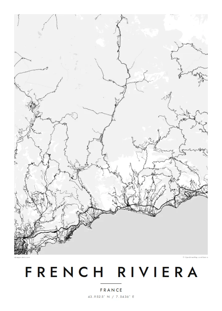
The French Riviera, or Côte d'Azur, runs along the Mediterranean in the far southeast of France, up to the Italian border. From above it is a series of wide bays separated by rocky capes: the Baie des Anges at Nice, Cap d'Antibes, Cap Ferrat and Cap Martin. Behind them the land rises quickly into the foothills of the Alps, which push the towns down toward the water.
The coast became a winter resort for wealthy British and Russian visitors in the nineteenth century, which is why the seafront at Nice is still called the Promenade des Anglais. Cannes holds its international film festival along the Croisette, and the principality of Monaco fills a tight pocket of coast between Nice and Menton.
A French Riviera map poster shows three distinct layers: the long curve of the seafront promenades, the dense street networks of the cities, and the corniche roads cut higher up the slope. East of Nice, the Basse, Moyenne and Grande Corniche run roughly parallel one above another, while west of Cannes the red rocks of the Estérel give the shore a jagged edge.
Nice's wide bay follows a smooth arc lined by the Promenade des Anglais, with the old town and the port tucked behind the castle hill at its eastern end.
Between Nice and Menton three roads run at different heights along the slope, and their near-parallel lines stack up one above another over the coast.
Cap d'Antibes and Cap Ferrat push into the sea as rounded peninsulas, their quiet villa roads contrasting with the denser cities on either side.
Tee siitä omasi
Lisää päivämäärä, nimi tai oma tekstisi, vaihda tyyliä, kokoa tai suuntaa.
Ilmainen esikatselu on matalaresoluutioinen ja vesileimattu. Painetut julisteet ja HD-tiedostot renderöidään 300 DPI:n tarkkuudella, jopa 7,200 × 10,800 px asti, ilman vesileimaa.
Miksi French Riviera
It suits anyone who has lived on the coast, spent summers there or remembers one particular town. Set the title to Nice, Côte d'Azur or a place of your own, add a date in the subtitle, and move the coordinates to the spot that matters.
Noir gives the Mediterranean a night-time depth, while Sand suits the warm light of the coast. Classic black & white, Paper and Blueprint complete the five styles. Printed posters come on matte paper and ship from partners in more than 30 countries.
Tilaa French Riviera-juliste| Tulostekoko | Resoluutio | Tiedostot |
|---|---|---|
| 30 × 40 cm11.8 × 15.7″ | 3,543 × 4,724 px | PNG · PDF |
| 29.7 × 42 cm (A3)11.7 × 16.5″ | 3,508 × 4,961 px | PNG · PDF |
| 42 × 59.4 cm (A2)16.5 × 23.4″ | 4,961 × 7,016 px | PNG · PDF |
| 45.7 × 61 cm18 × 24″ | 5,400 × 7,200 px | PNG · PDF |
| 50 × 70 cm19.7 × 27.6″ | 5,906 × 8,268 px | PNG · PDF |
| 61 × 91.4 cm24 × 36″ | 7,200 × 10,800 px | PNG · PDF |
Vertailun vuoksi: ilmainen esikatselu on 900 px leveä, vesileimattu ja tarkoitettu näytöille. HD-tiedostojen resoluutio on jopa 8-kertainen kumpaankin suuntaan, ja ne tulostuvat siististi täydessä julistekoossa.
Valitse tyyli sivun yläosasta ja sen jälkeen Painettu juliste — koko ja halutessasi kehys — tai Digitaaliset HD-tiedostot. Kassalla on vain yksi vaihe, ja tilaussivusi päivittyy heti maksun jälkeen.
Se painetaan laadukkaalle 200 g/m² mattapaperille kuudessa eri koossa, 30 × 40 cm:stä 24 × 36″:een. Painetut julisteet alkaen $39, toimitus sisältyy hintaan.
Kyllä. Valitse massiivipuinen kehys mustana, valkoisena, luonnontammena tai tummana puuna. Kehykseen kuuluu iskunkestävä lasitus, ja se on heti ripustusvalmis. Kehystetyt julisteet alkaen $99, toimitus sisältyy hintaan.
Toimitus on ilmainen yli 60 maahan. Jokaisen julisteen tulostaa lähin painokumppanimme yli 30 maassa, ja se saapuu yleensä 3–7 arkipäivässä. Voit seurata tilaa ja seurantatietoja kohdassa Omat tilaukset. Joihinkin maihin toimitus kestää 2–5 viikkoa, ja jos emme vielä toimita maahasi, sivusto kertoo siitä ennen maksamista.
Lähetä meille kuva 14 päivän kuluessa toimituksesta, niin painamme uuden veloituksetta tai palautamme rahasi.
Kyllä. Muokkaa tämän sivun editorissa otsikkoa, alaotsikkoa ja koordinaattirivi haluamallasi tavalla, ja valitse tyyli ja koko. Painetut, kehystetyt ja digitaaliset tilaukset käyttävät kaikki juuri sinun suunnitelmaasi.
Hintaan $9 saat 300 DPI:n PNG- ja tulostusvalmiit PDF-tiedostot kaikissa kuudessa koossa, ilman vesileimaa, tulostettavaksi missä tahansa. Etkö ole vielä varma? Lataa ensin ilmainen esikatselu vesileimalla.
Lähistöllä
