Überlinger See
The long, narrow northwestern arm reaches deep into the German shore. This slender finger of water gives the lake its distinctive asymmetric outline.
Minimalistinen karttajuliste · Saksa
47.6478° N / 9.3063° E
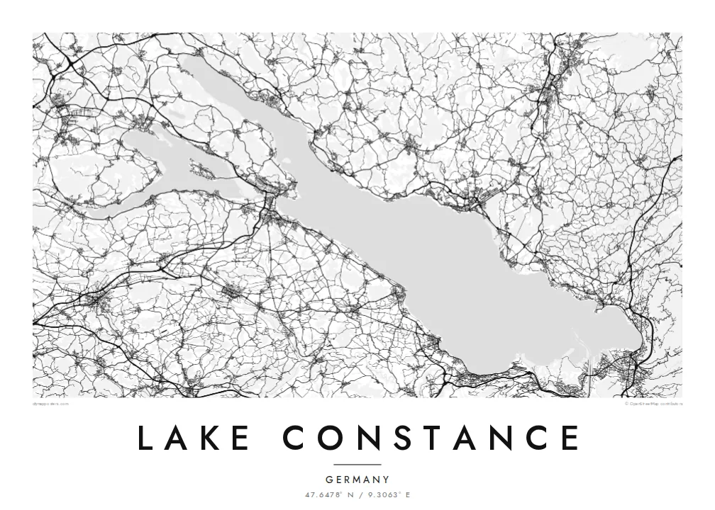
A broad lake shared by Germany, Austria and Switzerland, branching at its western end into slender arms and islands.


Yksi kaupunki, viisi tunnelmaa
Napauta tyyliä nähdäksesi sen seinällä. Kaikki tyylit maksavat saman verran — painettuna, kehystettynä tai HD-tiedostoina.
 Todelliset pikselit · 24 × 36″ tulostustiedosto
Terävä painojälki
Tämä on 100 %:n rajaus todellisesta tulostustiedostosta. Jokainen juliste — painettu, kehystetty tai ladattu — renderöidään palvelimillamme 300 DPI:n tarkkuudella, jopa 7,200 × 10,800 pikseliin asti, joten pienimmätkin kadut pysyvät terävinä 24 × 36″ -tulosteessa.
Seinällä


Kartta
Lake Constance, the Bodensee, lies at the northern edge of the Alps where Germany, Austria and Switzerland meet. Its main body, the Obersee, is a wide basin running from Bregenz in the southeast to the Überlinger See in the northwest. A separate lower lake, the Untersee, lies beyond the city of Konstanz, with a short stretch of the Rhine between the two.
The Rhine enters the lake near Bregenz and leaves at the western end, continuing toward the Rhine Falls. Unusually, the three countries have never agreed on a precise border through the Obersee, so much of the open water has no fixed dividing line. Around the shore, Lindau, Friedrichshafen, Meersburg, Konstanz and Bregenz form a ring of harbour towns.
The islands add detail to the outline. Lindau's old town sits on an island linked to the shore, Mainau is known for its gardens, and Reichenau, with its early medieval monasteries, is a UNESCO World Heritage site. A Lake Constance map poster shows the shores of all three countries together, framed around a single body of water.
The long, narrow northwestern arm reaches deep into the German shore. This slender finger of water gives the lake its distinctive asymmetric outline.
At the eastern end, Lindau's historic centre occupies a small island joined to the mainland by a road bridge and a railway embankment.
Konstanz sits where the Obersee narrows into the Rhine, which flows briefly as a river before widening into the Untersee around the island of Reichenau.
Tee siitä omasi
Lisää päivämäärä, nimi tai oma tekstisi, vaihda tyyliä, kokoa tai suuntaa.
Ilmainen esikatselu on matalaresoluutioinen ja vesileimattu. Painetut julisteet ja HD-tiedostot renderöidään 300 DPI:n tarkkuudella, jopa 7,200 × 10,800 px asti, ilman vesileimaa.
Miksi Lake Constance
Lake Constance is a shared home for people in three countries and a regular destination for cycling tours, sailing and summer holidays. A map of the whole lake connects every harbour, which makes it a fitting gift for anyone who knows its shores.
Personalise the title and subtitle, perhaps with Bodensee or a town name and a date, and choose from Classic black & white, Noir, Paper, Blueprint and Sand. The HD files cost $9 for all six sizes, and printed posters ship from partners in more than 30 countries.
Tilaa Lake Constance-juliste| Tulostekoko | Resoluutio | Tiedostot |
|---|---|---|
| 30 × 40 cm11.8 × 15.7″ | 3,543 × 4,724 px | PNG · PDF |
| 29.7 × 42 cm (A3)11.7 × 16.5″ | 3,508 × 4,961 px | PNG · PDF |
| 42 × 59.4 cm (A2)16.5 × 23.4″ | 4,961 × 7,016 px | PNG · PDF |
| 45.7 × 61 cm18 × 24″ | 5,400 × 7,200 px | PNG · PDF |
| 50 × 70 cm19.7 × 27.6″ | 5,906 × 8,268 px | PNG · PDF |
| 61 × 91.4 cm24 × 36″ | 7,200 × 10,800 px | PNG · PDF |
Vertailun vuoksi: ilmainen esikatselu on 900 px leveä, vesileimattu ja tarkoitettu näytöille. HD-tiedostojen resoluutio on jopa 8-kertainen kumpaankin suuntaan, ja ne tulostuvat siististi täydessä julistekoossa.
Valitse tyyli sivun yläosasta ja sen jälkeen Painettu juliste — koko ja halutessasi kehys — tai Digitaaliset HD-tiedostot. Kassalla on vain yksi vaihe, ja tilaussivusi päivittyy heti maksun jälkeen.
Se painetaan laadukkaalle 200 g/m² mattapaperille kuudessa eri koossa, 30 × 40 cm:stä 24 × 36″:een. Painetut julisteet alkaen $39, toimitus sisältyy hintaan.
Kyllä. Valitse massiivipuinen kehys mustana, valkoisena, luonnontammena tai tummana puuna. Kehykseen kuuluu iskunkestävä lasitus, ja se on heti ripustusvalmis. Kehystetyt julisteet alkaen $99, toimitus sisältyy hintaan.
Toimitus on ilmainen yli 60 maahan. Jokaisen julisteen tulostaa lähin painokumppanimme yli 30 maassa, ja se saapuu yleensä 3–7 arkipäivässä. Voit seurata tilaa ja seurantatietoja kohdassa Omat tilaukset. Joihinkin maihin toimitus kestää 2–5 viikkoa, ja jos emme vielä toimita maahasi, sivusto kertoo siitä ennen maksamista.
Lähetä meille kuva 14 päivän kuluessa toimituksesta, niin painamme uuden veloituksetta tai palautamme rahasi.
Kyllä. Muokkaa tämän sivun editorissa otsikkoa, alaotsikkoa ja koordinaattirivi haluamallasi tavalla, ja valitse tyyli ja koko. Painetut, kehystetyt ja digitaaliset tilaukset käyttävät kaikki juuri sinun suunnitelmaasi.
Hintaan $9 saat 300 DPI:n PNG- ja tulostusvalmiit PDF-tiedostot kaikissa kuudessa koossa, ilman vesileimaa, tulostettavaksi missä tahansa. Etkö ole vielä varma? Lataa ensin ilmainen esikatselu vesileimalla.
Lähistöllä
