Planned hillside estates
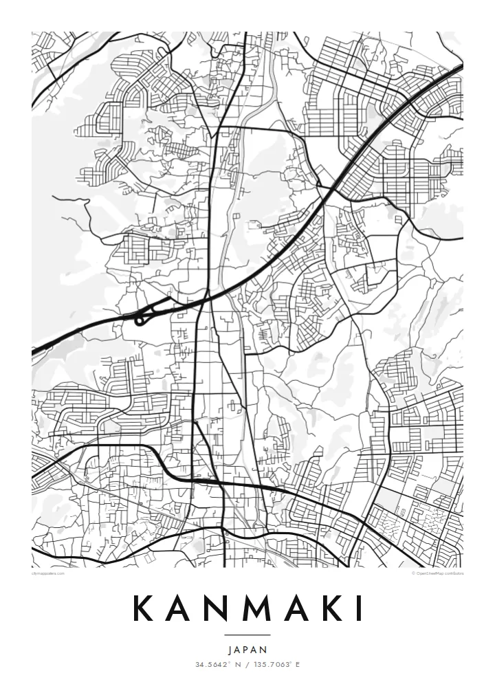
Residential districts on the hills are laid out with looping roads and regular lots. They form distinctive curved patterns on the map.
Minimalist na map poster · Japan
34.5642° N / 135.7063° E
A residential town on the western edge of the Nara Basin, with curving hillside estates and older lanes below


Isang lungsod, limang mood
I-tap ang isang estilo para makita ito sa dingding. Pareho ang presyo ng bawat estilo — naka-print, naka-frame, o bilang HD files.
 Aktwal na pixels · 24 × 36″ print file
Matalas sa print
Ito ay 100% crop ng aktwal na print file. Bawat poster — naka-print, naka-frame, o na-download — ay ginagawa sa aming mga server sa 300 DPI, hanggang 7,200 × 10,800 pixels, kaya malinaw pa rin ang pinakamaliliit na kalye kahit sa 24 × 36″ na print.
Sa dingding


Ang mapa
Kanmaki is a town in Kitakatsuragi District, Nara Prefecture, on the western side of the Nara Basin. It sits within commuting distance of Osaka, and much of its growth came from residential development in the late twentieth century, on the low hills that rise toward the western edge of the basin.
That history is visible from above. Newer housing areas appear as planned patterns of curving roads and neatly repeated lots, set into the hillsides. Lower down, older settlement follows the flatter ground and older roads, and the lanes there are narrower and less regular. Railway lines and main roads link the two.
The Nara Basin is one of the oldest settled areas in Japan, and the countryside around Kanmaki is dotted with ancient burial mounds. A Kanmaki map poster shows this quiet mix of old lanes, planned housing and green slopes on Nara's western edge.
Residential districts on the hills are laid out with looping roads and regular lots. They form distinctive curved patterns on the map.
On the lower ground, the street pattern is older and less regular. It is a denser, finer texture than the planned areas above.
Wooded slopes and open land border the built-up area, giving the town a soft outline against the hills.
Gawin mong sa iyo
Magdagdag ng petsa, pangalan o sarili mong linya, at palitan ang estilo, sukat o oryentasyon.
Ang libreng preview ay low-resolution na may watermark. Ang mga print at HD files ay ginagawa sa 300 DPI, hanggang 7,200 × 10,800 px, walang watermark.
Bakit Kanmaki
Kanmaki is where people raise families and commute from. It is home in an everyday sense, and a map of it is a simple way to remember a first house or a childhood neighbourhood.
The title, subtitle and coordinates line can be personalised with names, dates or an address. Choose from the five styles, Classic black & white, Noir, Paper, Blueprint and Sand, to suit the room.
I-order ang Kanmaki poster| Sukat ng print | Resolution | Mga file |
|---|---|---|
| 30 × 40 cm11.8 × 15.7″ | 3,543 × 4,724 px | PNG · PDF |
| 29.7 × 42 cm (A3)11.7 × 16.5″ | 3,508 × 4,961 px | PNG · PDF |
| 42 × 59.4 cm (A2)16.5 × 23.4″ | 4,961 × 7,016 px | PNG · PDF |
| 45.7 × 61 cm18 × 24″ | 5,400 × 7,200 px | PNG · PDF |
| 50 × 70 cm19.7 × 27.6″ | 5,906 × 8,268 px | PNG · PDF |
| 61 × 91.4 cm24 × 36″ | 7,200 × 10,800 px | PNG · PDF |
Bilang paghahambing, ang libreng preview ay 900 px ang lapad, may watermark at para lang sa screen. Ang HD files ay may hanggang 8× na resolution sa bawat direksyon at malinis na napi-print sa buong laki ng poster.
Pumili ng estilo sa itaas ng page, pagkatapos ay piliin ang Printed Poster — isang size at, kung gusto mo, isang frame — o Digital HD Files. Isang hakbang lang ang checkout, at agad na mag-a-update ang iyong order page kapag natapos na ang bayad.
Naka-print ito sa premium na 200 gsm matte paper sa isa sa anim na sizes, mula 30 × 40 cm hanggang 24 × 36″. Nagsisimula ang naka-print na poster sa $39, kasama na ang shipping.
Oo. Pumili ng solid wood frame sa itim, puti, natural oak, o dark wood. May kasamang shatterproof glazing at handa nang isabit. Nagsisimula ang naka-frame na poster sa $99, kasama na ang shipping.
Libre ang shipping sa 60+ bansa. Ipi-print ang bawat poster ng pinakamalapit sa aming mga print partner sa 30+ bansa, at karaniwang dumarating ito sa loob ng 3–7 araw ng negosyo. Masusundan mo ang status at tracking sa Aking Mga Order. Ang ilang bansa ay inaabot ng 2–5 linggo, at kung hindi pa kami nagpapadala sa inyo, sasabihin ito ng site bago ka magbayad.
Magpadala lang ng larawan sa loob ng 14 na araw mula sa paghahatid at ipapa-print namin ulit ito nang libre o irerefund ka namin.
Oo. Sa editor sa page na ito, baguhin ang title, subtitle, at coordinates line sa anumang gusto mo, at pumili ng estilo at size. Ginagamit ng naka-print, naka-frame, at digital na order ang eksaktong disenyo mo.
Para sa $9, makukuha mo ang 300 DPI PNG at print-ready PDF files sa lahat ng anim na sizes, walang watermark, para ma-print kahit saan. Hindi pa sigurado? Mag-download muna ng libreng preview na may watermark.
Malapit
