Ria Formosa lagoon
Behind a line of narrow sandy islands lies a maze of tidal channels and marsh, drawn as fine branching water lines around Faro and Olhão.
Minimalistički poster s kartom · Portugal
37.2445° N / 8.1960° W
Portugal's southern edge, from barrier islands and lagoons in the east to carved cliffs and a sharp southwestern cape


Jedan grad, pet ugođaja
Dodirnite stil da ga vidite na zidu. Svi stilovi koštaju isto — tiskani, uokvireni ili kao HD datoteke.
 Stvarni pikseli · print datoteka 24 × 36″
Oštro za tisak
Ovo je 100% izrezak stvarne print datoteke. Svaki poster — tiskani, uokvireni ili preuzet — renderira se na našim serverima u 300 DPI, do 7,200 × 10,800 piksela, tako da čak i najsitnije linije ostanu oštre na ispisu 24 × 36″.
Na zidu


Karta
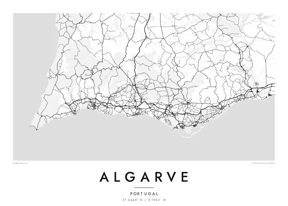
The Algarve is the southernmost region of mainland Portugal, a long band of coast between the Guadiana river on the Spanish border and Cape St. Vincent. Its shape changes along the way. East of Faro the shore becomes a chain of sandy barrier islands, while west of Albufeira and around Lagos it breaks up into cliffs, arches and small coves.
The Ria Formosa, a protected lagoon behind the barrier islands, surrounds Faro, the regional capital, with marshes, channels and salt pans. At the far west, Sagres and Cape St. Vincent form the southwestern tip of mainland Europe, a place long associated with Portugal's age of sea exploration. Inland, the Serra de Monchique rises as a green range behind the coast.
An Algarve map poster puts these two coasts on one sheet: the soft lagoons and long sand spits in the east, and the ragged rock formations of Ponta da Piedade near Lagos in the west. Between them, towns such as Portimão sit at river mouths, and the streets of resort districts fill the low ground close to the shore.
Behind a line of narrow sandy islands lies a maze of tidal channels and marsh, drawn as fine branching water lines around Faro and Olhão.
South of Lagos the cliffs break up into sea stacks, arches and grottoes, giving this part of the coastline a jagged, finely detailed edge.
At the western end the coast turns sharply north at a bare headland, the corner where the south-facing shore meets Portugal's Atlantic west coast.
Prilagodite ga sebi
Dodajte datum, ime ili vlastiti redak teksta, promijenite stil, veličinu ili orijentaciju.
Besplatni pregled je niske rezolucije s vodenim žigom. Tiskani posteri i HD datoteke renderiraju se u 300 DPI, do 7,200 × 10,800 px, bez vodenog žiga.
Zašto Algarve
It works for families who have holidayed in the same resort for years and for people who have moved to the region. Write the town or the villa's name in the title, a year in the subtitle, and set the coordinates to your own stretch of beach.
Choose Sand for a sunlit feel, Blueprint for the lagoon's intricate channels, or Classic black & white, Noir and Paper. The poster is available as a $9 HD download or as a printed matte poster, framed in wood if you like.
Naručite poster Algarve| Veličina otiska | Rezolucija | Datoteke |
|---|---|---|
| 30 × 40 cm11.8 × 15.7″ | 3,543 × 4,724 px | PNG · PDF |
| 29.7 × 42 cm (A3)11.7 × 16.5″ | 3,508 × 4,961 px | PNG · PDF |
| 42 × 59.4 cm (A2)16.5 × 23.4″ | 4,961 × 7,016 px | PNG · PDF |
| 45.7 × 61 cm18 × 24″ | 5,400 × 7,200 px | PNG · PDF |
| 50 × 70 cm19.7 × 27.6″ | 5,906 × 8,268 px | PNG · PDF |
| 61 × 91.4 cm24 × 36″ | 7,200 × 10,800 px | PNG · PDF |
Za usporedbu, besplatni pregled širok je 900 px, ima vodeni žig i namijenjen je zaslonima. HD datoteke imaju do 8× veću rezoluciju u svakom smjeru i čisto se tiskaju u punoj veličini postera.
Odaberite stil na vrhu stranice, a zatim Tiskani poster — veličinu i, ako želite, okvir — ili Digitalne HD datoteke. Naplata traje samo jedan korak, a stranica vaše narudžbe ažurira se čim plaćanje prođe.
Tiska se na premium mat papiru 200 g/m² u jednoj od šest veličina, od 30 × 40 cm do 24 × 36″. Tiskani posteri kreću od $39, dostava uključena.
Da. Odaberite okvir od masivnog drveta u crnoj, bijeloj, prirodnoj hrastovoj ili tamnoj boji drveta. Dolazi sa staklom otpornim na lom i spreman je za vješanje. Uokvireni posteri kreću od $99, dostava uključena.
Dostava je besplatna u 60+ zemalja. Svaki poster tiska najbliži od naših partnera za tisak u 30+ zemalja, a obično stiže za 3–7 radnih dana. Status i praćenje pošiljke možete pratiti u odjeljku Moje narudžbe. Za nekoliko zemalja dostava traje 2–5 tjedana, a ako još ne dostavljamo u vašu zemlju, stranica će vas na to upozoriti prije plaćanja.
Pošaljite nam fotografiju u roku od 14 dana od dostave i besplatno ćemo ga ponovno tiskati ili vratiti novac.
Da. U uređivaču na ovoj stranici promijenite naslov, podnaslov i redak s koordinatama u što god želite, te odaberite stil i veličinu. Tiskane, uokvirene i digitalne narudžbe koriste točno vaš dizajn.
Za $9 dobivate 300 DPI PNG i PDF datoteke spremne za tisak u svih šest veličina, bez vodenog žiga, za ispis bilo gdje. Niste sigurni? Prvo preuzmite besplatan pregled s vodenim žigom.
