Arroyo de las Vacas
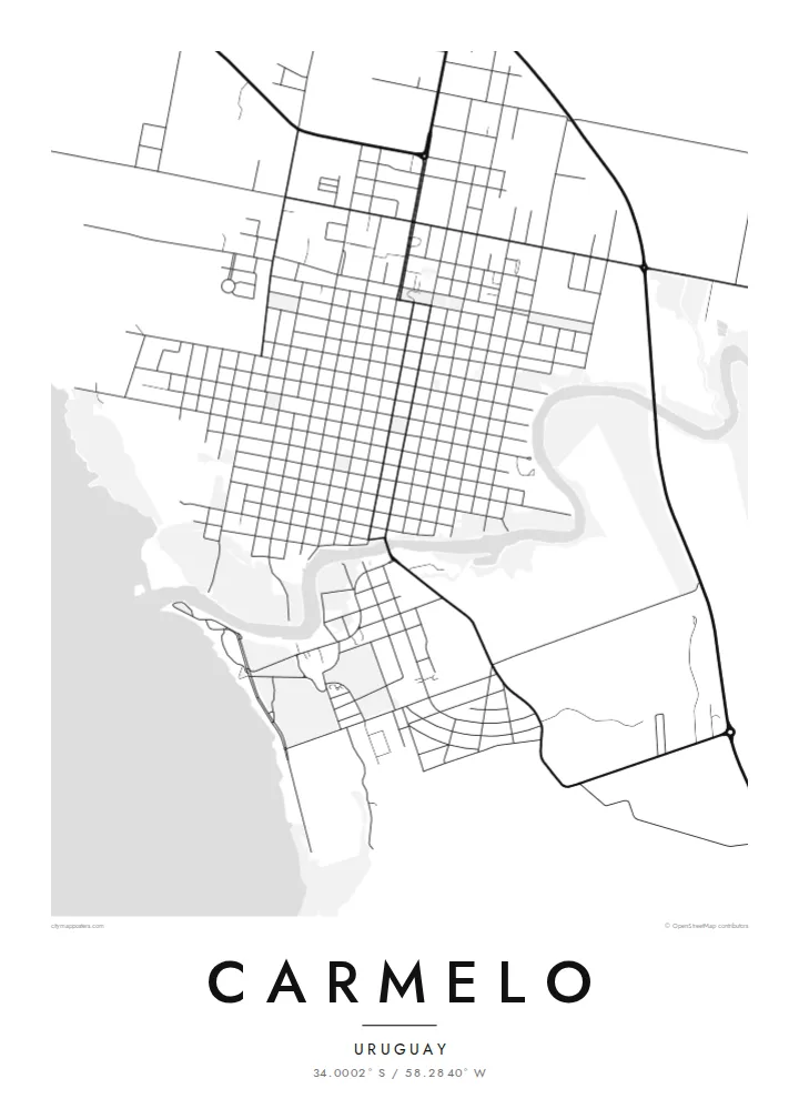
The creek curves along the edge of town before reaching the Río de la Plata. It separates the grid from the green land opposite and gives the map its main curve.
Minimalistički poster s kartom · Urugvaj
34.0002° S / 58.2840° W
A riverside grid on the Río de la Plata, split by a creek and joined by an old swing bridge.


Jedan grad, pet ugođaja
Dodirnite stil da ga vidite na zidu. Svi stilovi koštaju isto — tiskani, uokvireni ili kao HD datoteke.
 Stvarni pikseli · print datoteka 24 × 36″
Oštro za tisak
Ovo je 100% izrezak stvarne print datoteke. Svaki poster — tiskani, uokvireni ili preuzet — renderira se na našim serverima u 300 DPI, do 7,200 × 10,800 piksela, tako da čak i najsitnije linije ostanu oštre na ispisu 24 × 36″.
Na zidu


Karta
Carmelo sits in the department of Colonia, where the Arroyo de las Vacas meets the wide, brown estuary of the Río de la Plata. The town was founded in 1816 under José Gervasio Artigas. Its plan follows the regular Spanish colonial grid, with square blocks running inland from the waterfront and a central plaza not far from the creek.
The creek is the defining line on the map. It separates the town from the green ground to the south and is crossed by an early twentieth-century swing bridge, the first of its kind in Uruguay and still a local emblem. Boats moor along the arroyo, and launches leave for the Argentine delta across the water.
The Carmelo map poster shows this meeting of grid, creek and estuary with unusual clarity. Streets end cleanly at the shoreline, the arroyo winds out toward the river, and the farmland beyond turns into open space. It is a balanced, legible composition for anyone who knows this quiet corner of western Uruguay.
The creek curves along the edge of town before reaching the Río de la Plata. It separates the grid from the green land opposite and gives the map its main curve.
The historic bridge over the arroyo turns on a pivot to let boats through. It marks the one place where the town's main road crosses the water.
Square blocks laid out in the early nineteenth century run in orderly rows from the plaza toward the river, a pattern that reads crisply in fine black lines.
Prilagodite ga sebi
Dodajte datum, ime ili vlastiti redak teksta, promijenite stil, veličinu ili orijentaciju.
Besplatni pregled je niske rezolucije s vodenim žigom. Tiskani posteri i HD datoteke renderiraju se u 300 DPI, do 7,200 × 10,800 px, bez vodenog žiga.
Zašto Carmelo
Carmelo draws visitors for its wineries, its calm riverside and the boats to the Paraná delta. For them, and for Uruguayan families with roots here, a map of the town is a simple record of a place that moves more slowly than the capital.
You can edit the title, subtitle and coordinates line, so the poster can carry a name, a wedding date or the year of a trip. Choose Classic black & white, Noir, Paper, Blueprint or Sand. Check the free 900 px preview first, then buy the HD files for $9 or a printed poster.
Naručite poster Carmelo| Veličina otiska | Rezolucija | Datoteke |
|---|---|---|
| 30 × 40 cm (11.8 × 15.7″) | 3,543 × 4,724 px | PNG · PDF |
| 29.7 × 42 cm (A3, 11.7 × 16.5″) | 3,508 × 4,961 px | PNG · PDF |
| 42 × 59.4 cm (A2, 16.5 × 23.4″) | 4,961 × 7,016 px | PNG · PDF |
| 45.7 × 61 cm (18 × 24″) | 5,400 × 7,200 px | PNG · PDF |
| 50 × 70 cm (19.7 × 27.6″) | 5,906 × 8,268 px | PNG · PDF |
| 61 × 91.4 cm (24 × 36″) | 7,200 × 10,800 px | PNG · PDF |
Za usporedbu, besplatni pregled širok je 900 px, ima vodeni žig i namijenjen je zaslonima. HD datoteke imaju do 8× veću rezoluciju u svakom smjeru i čisto se tiskaju u punoj veličini postera.
Odaberite stil na vrhu stranice, a zatim Tiskani poster — veličinu i, ako želite, okvir — ili Digitalne HD datoteke. Naplata traje samo jedan korak, a stranica vaše narudžbe ažurira se čim plaćanje prođe.
Tiska se na premium mat papiru 200 g/m² u jednoj od šest veličina, od 30 × 40 cm do 24 × 36″. Tiskani posteri kreću od $39, dostava uključena.
Da. Odaberite okvir od masivnog drveta u crnoj, bijeloj, prirodnoj hrastovoj ili tamnoj boji drveta. Dolazi sa staklom otpornim na lom i spreman je za vješanje. Uokvireni posteri kreću od $99, dostava uključena.
Dostava je besplatna u cijelom svijetu. Svaki plakat tiska najbliži od naših tiskarskih partnera u više od 30 zemalja, a obično stiže za 3–7 radnih dana. Status i praćenje pošiljke možete pratiti u odjeljku Moje narudžbe. U nekim zemljama dostava traje 2–5 tjedana, a ako još ne dostavljamo u vašu zemlju, stranica će vas na to upozoriti prije plaćanja.
Pošaljite nam fotografiju u roku od 14 dana od dostave i besplatno ćemo ga ponovno tiskati ili vratiti novac.
Da. U uređivaču na ovoj stranici promijenite naslov, podnaslov i redak s koordinatama u što god želite, te odaberite stil i veličinu. Tiskane, uokvirene i digitalne narudžbe koriste točno vaš dizajn.
Za $9 dobivate 300 DPI PNG i PDF datoteke spremne za tisak u svih šest veličina, bez vodenog žiga, za ispis bilo gdje. Niste sigurni? Prvo preuzmite besplatan pregled s vodenim žigom.
U blizini
