Great Belt link
The fixed link to Zealand leaves Funen's east coast near Nyborg and crosses the strait by way of the small island of Sprogø. On the map it is a long, straight line across open water.
Minimalistički poster s kartom · Danska
55.3367° N / 10.2666° E
A broad, rounded Danish island between two straits, with Odense near its centre and an archipelago scattered off its southern coast


Jedan grad, pet ugođaja
Dodirnite stil da ga vidite na zidu. Svi stilovi koštaju isto — tiskani, uokvireni ili kao HD datoteke.
 Stvarni pikseli · print datoteka 24 × 36″
Oštro za tisak
Ovo je 100% izrezak stvarne print datoteke. Svaki poster — tiskani, uokvireni ili preuzet — renderira se na našim serverima u 300 DPI, do 7,200 × 10,800 piksela, tako da čak i najsitnije linije ostanu oštre na ispisu 24 × 36″.
Na zidu


Karta
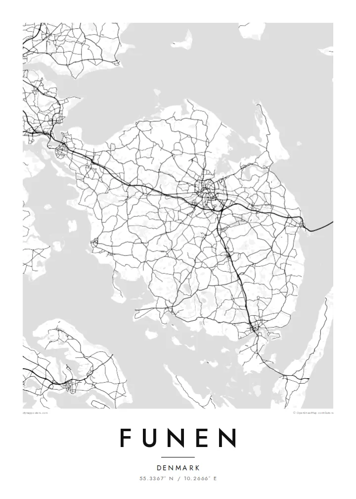
Funen lies between Jutland and Zealand, and on a map it sits squarely in the middle of Denmark, with the Little Belt to the west and the Great Belt to the east. The island is broad and compact. Country roads cross gently rolling farmland, small towns are spaced evenly across the land, and the coastline is cut by shallow fjords and bays.
Odense, the island's largest city and one of the oldest in Denmark, sits near the centre. Ring roads surround its historic core, and a canal leads north to Odense Fjord. The city is the birthplace of Hans Christian Andersen. Bridges carry road and rail west to Jutland, and the long Great Belt link runs east toward Zealand.
South of the island lies the South Funen Archipelago, with Tåsinge, Ærø and many smaller islands reached by bridge and ferry. Castles and manor estates are scattered across the countryside, among them Egeskov with its moat. A Funen map poster shows the island as a hub: the city at the centre, bridges on either side and islands trailing off to the south.
The fixed link to Zealand leaves Funen's east coast near Nyborg and crosses the strait by way of the small island of Sprogø. On the map it is a long, straight line across open water.
At the heart of the island, ring roads enclose Odense's old centre. The river Odense Å winds through it and through parks, and a canal carries on north to the fjord.
Off the south coast, a scatter of islands and islets breaks up the water around Svendborg Sound. It turns the bottom of the map into a mosaic of small coastlines.
Prilagodite ga sebi
Dodajte datum, ime ili vlastiti redak teksta, promijenite stil, veličinu ili orijentaciju.
Besplatni pregled je niske rezolucije s vodenim žigom. Tiskani posteri i HD datoteke renderiraju se u 300 DPI, do 7,200 × 10,800 px, bez vodenog žiga.
Zašto Funen
This is a map for people from Odense, Svendborg or the small towns in between, and for anyone who thinks of Funen as the green middle of Denmark. The rounded shape, the bridges and the southern islands give the print a pleasing balance.
You can personalise the title, subtitle and coordinates, add a date that matters to you, and choose one of five styles. The $9 digital files cover six sizes, including 50×70 cm and A2, each as a 300 DPI PNG and a print-ready PDF.
Naručite poster Funen| Veličina otiska | Rezolucija | Datoteke |
|---|---|---|
| 30 × 40 cm (11.8 × 15.7″) | 3,543 × 4,724 px | PNG · PDF |
| 29.7 × 42 cm (A3, 11.7 × 16.5″) | 3,508 × 4,961 px | PNG · PDF |
| 42 × 59.4 cm (A2, 16.5 × 23.4″) | 4,961 × 7,016 px | PNG · PDF |
| 45.7 × 61 cm (18 × 24″) | 5,400 × 7,200 px | PNG · PDF |
| 50 × 70 cm (19.7 × 27.6″) | 5,906 × 8,268 px | PNG · PDF |
| 61 × 91.4 cm (24 × 36″) | 7,200 × 10,800 px | PNG · PDF |
Za usporedbu, besplatni pregled širok je 900 px, ima vodeni žig i namijenjen je zaslonima. HD datoteke imaju do 8× veću rezoluciju u svakom smjeru i čisto se tiskaju u punoj veličini postera.
Odaberite stil na vrhu stranice, a zatim Tiskani poster — veličinu i, ako želite, okvir — ili Digitalne HD datoteke. Naplata traje samo jedan korak, a stranica vaše narudžbe ažurira se čim plaćanje prođe.
Tiska se na premium mat papiru 200 g/m² u jednoj od šest veličina, od 30 × 40 cm do 24 × 36″. Tiskani posteri kreću od {printFrom}, dostava uključena.
Da. Odaberite okvir od masivnog drveta u crnoj, bijeloj, prirodnoj hrastovoj ili tamnoj boji drveta. Dolazi sa staklom otpornim na lom i spreman je za vješanje. Uokvireni posteri kreću od {framedFrom}, dostava uključena.
Dostava je besplatna diljem svijeta. Svaki poster tiska najbliži od naših tiskarskih partnera u više od 30 zemalja i obično stiže za 3–7 radnih dana. Status i praćenje možete pratiti u Moje narudžbe.
Pošaljite nam fotografiju u roku od 14 dana od dostave i besplatno ćemo ga ponovno tiskati ili vratiti novac.
Da. U uređivaču na ovoj stranici promijenite naslov, podnaslov i redak s koordinatama u što god želite, te odaberite stil i veličinu. Tiskane, uokvirene i digitalne narudžbe koriste točno vaš dizajn.
Za $9 dobivate 300 DPI PNG i PDF datoteke spremne za tisak u svih šest veličina, bez vodenog žiga, za ispis bilo gdje. Niste sigurni? Prvo preuzmite besplatan pregled s vodenim žigom.
U blizini
