The crater harbour
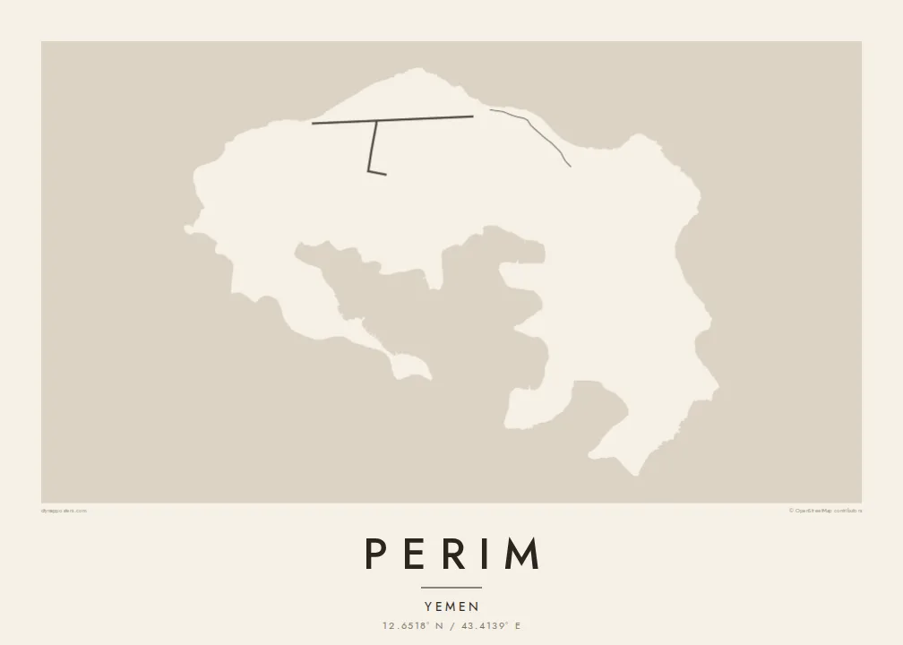
The island's core is a sheltered bay enclosed by curving arms of land, the flooded heart of an old volcano. It gives Perim its unmistakable horseshoe outline on the map.
Minimalistički poster s kartom · Jemen
12.6518° N / 43.4139° E
A small volcanic horseshoe in the Bab-el-Mandeb strait, curled around a sheltered natural harbour.




Jedan grad, pet ugođaja
Dodirnite stil da ga vidite na zidu. Svi stilovi koštaju isto — tiskani, uokvireni ili kao HD datoteke.
 Stvarni pikseli · print datoteka 24 × 36″
Oštro za tisak
Ovo je 100% izrezak stvarne print datoteke. Svaki poster — tiskani, uokvireni ili preuzet — renderira se na našim serverima u 300 DPI, do 7,200 × 10,800 piksela, tako da čak i najsitnije linije ostanu oštre na ispisu 24 × 36″.
Na zidu


Karta
Perim is a small island in the Bab-el-Mandeb, the strait that joins the Red Sea to the Gulf of Aden. It lies close to the Yemeni coast, in the narrow channel between Arabia and Africa. Its shape is the first thing you notice. The island is the remains of a volcanic crater, curled into a rough horseshoe around a deep, enclosed bay.
That natural harbour and the island's position on one of the world's busiest sea lanes gave Perim an outsized role in the past. In the late nineteenth and early twentieth centuries, the British used it as a coaling station for ships travelling between the Suez Canal and the Indian Ocean. Today it is sparsely inhabited, and it is known in Arabic as Mayun.
A Perim map poster is almost entirely about the coastline. The curved arms of the island wrap around the inner bay, and there is only a light scatter of lines on the land itself. Open water frames the island on all sides. The result is a spare, graphic shape that is easy to recognise at any size.
The island's core is a sheltered bay enclosed by curving arms of land, the flooded heart of an old volcano. It gives Perim its unmistakable horseshoe outline on the map.
Perim sits in the Bab-el-Mandeb, between the Arabian Peninsula and the Horn of Africa. At a wider framing, the poster shows the island guarding the narrow passage.
There are very few roads or buildings on the island. That leaves the land mostly blank, so the outline and inner harbour carry the entire composition.
Prilagodite ga sebi
Dodajte datum, ime ili vlastiti redak teksta, promijenite stil, veličinu ili orijentaciju.
Besplatni pregled je niske rezolucije s vodenim žigom. Tiskani posteri i HD datoteke renderiraju se u 300 DPI, do 7,200 × 10,800 px, bez vodenog žiga.
Zašto Perim
Perim appeals to people drawn to maritime history, shipping routes and unusual geography. Its horseshoe shape is striking on its own, even for those who have never been there. It suits a study or office wall as a clean, almost abstract form with a real story behind it.
Add a title of your choosing, a subtitle and your own coordinates line, then pick from Classic black & white, Noir, Paper, Blueprint or Sand. The $9 digital download includes six sizes at 300 DPI with no watermark. Printed posters ship from partners in more than 30 countries.
Naručite poster Perim| Veličina otiska | Rezolucija | Datoteke |
|---|---|---|
| 30 × 40 cm (11.8 × 15.7″) | 3,543 × 4,724 px | PNG · PDF |
| 29.7 × 42 cm (A3, 11.7 × 16.5″) | 3,508 × 4,961 px | PNG · PDF |
| 42 × 59.4 cm (A2, 16.5 × 23.4″) | 4,961 × 7,016 px | PNG · PDF |
| 45.7 × 61 cm (18 × 24″) | 5,400 × 7,200 px | PNG · PDF |
| 50 × 70 cm (19.7 × 27.6″) | 5,906 × 8,268 px | PNG · PDF |
| 61 × 91.4 cm (24 × 36″) | 7,200 × 10,800 px | PNG · PDF |
Za usporedbu, besplatni pregled širok je 900 px, ima vodeni žig i namijenjen je zaslonima. HD datoteke imaju do 8× veću rezoluciju u svakom smjeru i čisto se tiskaju u punoj veličini postera.
Odaberite stil na vrhu stranice, a zatim Tiskani poster — veličinu i, ako želite, okvir — ili Digitalne HD datoteke. Naplata traje samo jedan korak, a stranica vaše narudžbe ažurira se čim plaćanje prođe.
Tiska se na premium mat papiru 200 g/m² u jednoj od šest veličina, od 30 × 40 cm do 24 × 36″. Tiskani posteri kreću od $39, dostava uključena.
Da. Odaberite okvir od masivnog drveta u crnoj, bijeloj, prirodnoj hrastovoj ili tamnoj boji drveta. Dolazi sa staklom otpornim na lom i spreman je za vješanje. Uokvireni posteri kreću od $99, dostava uključena.
Dostava je besplatna u cijelom svijetu. Svaki plakat tiska najbliži od naših tiskarskih partnera u više od 30 zemalja, a obično stiže za 3–7 radnih dana. Status i praćenje pošiljke možete pratiti u odjeljku Moje narudžbe. U nekim zemljama dostava traje 2–5 tjedana, a ako još ne dostavljamo u vašu zemlju, stranica će vas na to upozoriti prije plaćanja.
Pošaljite nam fotografiju u roku od 14 dana od dostave i besplatno ćemo ga ponovno tiskati ili vratiti novac.
Da. U uređivaču na ovoj stranici promijenite naslov, podnaslov i redak s koordinatama u što god želite, te odaberite stil i veličinu. Tiskane, uokvirene i digitalne narudžbe koriste točno vaš dizajn.
Za $9 dobivate 300 DPI PNG i PDF datoteke spremne za tisak u svih šest veličina, bez vodenog žiga, za ispis bilo gdje. Niste sigurni? Prvo preuzmite besplatan pregled s vodenim žigom.
U blizini
