Prairie grid
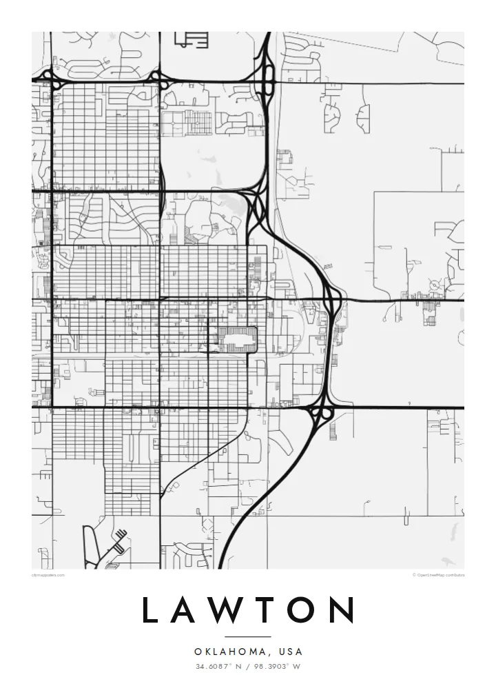
Numbered streets and avenues run north–south and east–west across flat land. They form one of the clearest and most regular urban grids in the southern Plains.
Minimalista térképposzter · Egyesült Államok
34.6087° N / 98.3903° W
A southwest Oklahoma city laid out on a prairie grid, beside Fort Sill and the rising Wichita Mountains.


Egy város, öt hangulat
Koppints egy stílusra, hogy lásd a falon. Minden stílus ugyanannyiba kerül — nyomtatva, kerettel vagy HD fájlként.
 Valódi pixelek · 24 × 36″ nyomtatási fájl
Nyomtatásban is éles
Ez a valódi nyomtatási fájl 100%-os kivágata. Minden poszter — nyomtatva, kerettel vagy letöltve — szervereinken 300 DPI-vel, akár 7,200 × 10,800 pixel felbontásban készül, így a legkisebb utcák is élesek maradnak egy 24 × 36″-os nyomaton is.
A falon


A térkép
Lawton was founded in 1901, when land from the former Kiowa, Comanche and Apache reservation was opened to settlement by lottery. The town was surveyed quickly on open prairie, and its map still reflects that origin. A clear grid of numbered streets and avenues, aligned to the compass, stretches out from the original town site.
Fort Sill, a large U.S. Army post established in 1869, lies directly north of the city and covers a large area on the map with its own roads, ranges and buildings. To the northwest the Wichita Mountains rise from the plains, home to a national wildlife refuge. Lakes and creeks add curved lines to the otherwise straight pattern.
A Lawton map poster sets a disciplined city grid against wide, open military land and the edge of the mountains. The contrast between the dense, regular streets and the sparse areas beyond gives the composition a strong structure. It is a meaningful piece for Army families who passed through Fort Sill and for people who grew up in the city itself.
Numbered streets and avenues run north–south and east–west across flat land. They form one of the clearest and most regular urban grids in the southern Plains.
The historic Army post occupies a large area north of the city. On the map it appears as a quieter zone with its own internal roads and wide open training ground.
To the northwest, the granite hills of the Wichita Mountains rise from the prairie. They add rugged, irregular ground and lakes at the edge of a wider composition.
Tedd a sajátoddá
Adj hozzá dátumot, nevet vagy saját szöveget, válts stílust, méretet vagy tájolást.
Az ingyenes előnézet alacsony felbontású és vízjeles. A nyomatok és a HD fájlok 300 DPI-vel, akár 7,200 × 10,800 px felbontásban készülnek, vízjel nélkül.
Miért Lawton?
Lawton means a great deal to the many service members stationed at Fort Sill over the years, as well as to families with deep Comanche County roots. A map poster marks a posting, a hometown or a first house in a plain, lasting way.
Personalise the title, subtitle and coordinates line, perhaps with the years of a posting. Choose Classic black & white, Noir, Paper, Blueprint or Sand. Download HD files for $9, or order a matte printed poster with an optional wooden frame.
Lawton poszter megrendelése| Nyomtatási méret | Felbontás | Fájlok |
|---|---|---|
| 30 × 40 cm11.8 × 15.7″ | 3,543 × 4,724 px | PNG · PDF |
| 29.7 × 42 cm (A3)11.7 × 16.5″ | 3,508 × 4,961 px | PNG · PDF |
| 42 × 59.4 cm (A2)16.5 × 23.4″ | 4,961 × 7,016 px | PNG · PDF |
| 45.7 × 61 cm18 × 24″ | 5,400 × 7,200 px | PNG · PDF |
| 50 × 70 cm19.7 × 27.6″ | 5,906 × 8,268 px | PNG · PDF |
| 61 × 91.4 cm24 × 36″ | 7,200 × 10,800 px | PNG · PDF |
Összehasonlításképp: az ingyenes előnézet 900 px széles, vízjeles, és képernyőn való megtekintésre készült. A HD fájlok mindkét irányban akár 8× nagyobb felbontásúak, és teljes poszterméretben is tisztán nyomtathatók.
Válassz egy stílust az oldal tetején, majd válaszd a Nyomtatott poszter opciót — méretet és, ha szeretnéd, keretet is — vagy a Digitális HD fájlokat. A fizetés egy lépésből áll, és a rendelési oldalad azonnal frissül, amint a fizetés megtörtént.
Prémium, 200 g/m²-es matt papírra nyomtatjuk, hat méretben, 30 × 40 cm-től 24 × 36″-ig. A nyomtatott poszterek ára $39-tól indul, szállítással együtt.
Igen. Válassz tömör fa keretet fekete, fehér, natúr tölgy vagy sötét fa színben. Törésálló üvegezéssel érkezik, azonnal felakasztható. A keretezett poszterek ára $99-tól indul, szállítással együtt.
A szállítás 60+ országba ingyenes. Minden plakátot a hozzánk legközelebbi nyomdai partnerünk nyomtat ki, több mint 30 országban, és általában 3–7 munkanap alatt érkezik meg. Az állapotot és a követést a Rendeléseim menüpontban követheted nyomon. Néhány országba 2–5 hétig tart a szállítás, és ahová még nem szállítunk, ott az oldal fizetés előtt jelzi.
Küldj nekünk egy fotót a kézbesítéstől számított 14 napon belül, és ingyen újranyomtatjuk, vagy visszatérítjük az összeget.
Igen. Az oldalon található szerkesztőben tetszés szerint módosíthatod a címet, az alcímet és a koordináták sorát, majd válassz stílust és méretet. A nyomtatott, keretezett és digitális rendelések is pontosan a te tervedet használják.
$9-ért 300 DPI-s PNG és nyomtatásra kész PDF fájlokat kapsz mind a hat méretben, vízjel nélkül, bárhol kinyomtathatod. Még nem vagy biztos benne? Töltsd le először az ingyenes, vízjeles előnézetet.
