Northern settlements
Brades, Little Bay and the surrounding villages gather most of the island's roads in the north, where winding lanes follow the ridges and valleys of the Silver and Centre Hills.
Minimalista térképposzter · Egyesült Királyság
16.7493° N / 62.1930° W
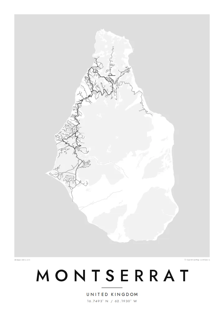
A small, pear-shaped Caribbean island whose green northern hills hold the towns while the volcanic south lies closed.


Egy város, öt hangulat
Koppints egy stílusra, hogy lásd a falon. Minden stílus ugyanannyiba kerül — nyomtatva, kerettel vagy HD fájlként.
 Valódi pixelek · 24 × 36″ nyomtatási fájl
Nyomtatásban is éles
Ez a valódi nyomtatási fájl 100%-os kivágata. Minden poszter — nyomtatva, kerettel vagy letöltve — szervereinken 300 DPI-vel, akár 7,200 × 10,800 pixel felbontásban készül, így a legkisebb utcák is élesek maradnak egy 24 × 36″-os nyomaton is.
A falon


A térkép
Montserrat is a British Overseas Territory in the Leeward Islands, around sixteen kilometres from north to south. Its shape narrows toward the north, and three groups of hills run down its length: the Silver Hills at the northern tip, the forested Centre Hills in the middle and the Soufrière Hills in the south. It has long been called the Emerald Isle of the Caribbean, partly for its Irish heritage.
Since 1995 the Soufrière Hills volcano has reshaped the island. Eruptions buried the former capital, Plymouth, and much of the south became an exclusion zone. A Montserrat map poster therefore shows an unusual pattern: roads and villages concentrated in the north, around Brades and Little Bay, and a southern half where the streets of the abandoned capital sit cut off from the rest of the network.
Life on the island moved north after the eruptions, and a new airport, new housing and a small port were built there. The volcano is still monitored closely, and the landscape around it continues to change with each period of activity. The result on paper is a map that records both an island and a recent turn in its history.
Brades, Little Bay and the surrounding villages gather most of the island's roads in the north, where winding lanes follow the ridges and valleys of the Silver and Centre Hills.
The volcano dominates the southern half, its slopes left largely without roads. On the poster this area reads as open ground, a clear graphic contrast with the settled north.
The former capital on the southwest coast was abandoned after the 1997 eruptions. Its street pattern still shows on the map, isolated inside the exclusion zone.
Tedd a sajátoddá
Adj hozzá dátumot, nevet vagy saját szöveget, válts stílust, méretet vagy tájolást.
Az ingyenes előnézet alacsony felbontású és vízjeles. A nyomatok és a HD fájlok 300 DPI-vel, akár 7,200 × 10,800 px felbontásban készülnek, vízjel nélkül.
Miért Montserrat?
People with family ties to Montserrat, and those who knew it before 1995, often want a map that shows the whole island rather than only its settled part. The compact outline fits comfortably on any of the print sizes and keeps its detail.
The title, subtitle and coordinates line can all be changed, so the poster might carry a family village or a year that matters. Pick one of five styles, Classic, Noir, Paper, Blueprint or Sand, then download 300 DPI files for $9 or order a printed poster with an optional wooden frame.
Montserrat poszter megrendelése| Nyomtatási méret | Felbontás | Fájlok |
|---|---|---|
| 30 × 40 cm11.8 × 15.7″ | 3,543 × 4,724 px | PNG · PDF |
| 29.7 × 42 cm (A3)11.7 × 16.5″ | 3,508 × 4,961 px | PNG · PDF |
| 42 × 59.4 cm (A2)16.5 × 23.4″ | 4,961 × 7,016 px | PNG · PDF |
| 45.7 × 61 cm18 × 24″ | 5,400 × 7,200 px | PNG · PDF |
| 50 × 70 cm19.7 × 27.6″ | 5,906 × 8,268 px | PNG · PDF |
| 61 × 91.4 cm24 × 36″ | 7,200 × 10,800 px | PNG · PDF |
Összehasonlításképp: az ingyenes előnézet 900 px széles, vízjeles, és képernyőn való megtekintésre készült. A HD fájlok mindkét irányban akár 8× nagyobb felbontásúak, és teljes poszterméretben is tisztán nyomtathatók.
Válassz egy stílust az oldal tetején, majd válaszd a Nyomtatott poszter opciót — méretet és, ha szeretnéd, keretet is — vagy a Digitális HD fájlokat. A fizetés egy lépésből áll, és a rendelési oldalad azonnal frissül, amint a fizetés megtörtént.
Prémium, 200 g/m²-es matt papírra nyomtatjuk, hat méretben, 30 × 40 cm-től 24 × 36″-ig. A nyomtatott poszterek ára $39-tól indul, szállítással együtt.
Igen. Válassz tömör fa keretet fekete, fehér, natúr tölgy vagy sötét fa színben. Törésálló üvegezéssel érkezik, azonnal felakasztható. A keretezett poszterek ára $99-tól indul, szállítással együtt.
A szállítás 60+ országba ingyenes. Minden plakátot a hozzánk legközelebbi nyomdai partnerünk nyomtat ki, több mint 30 országban, és általában 3–7 munkanap alatt érkezik meg. Az állapotot és a követést a Rendeléseim menüpontban követheted nyomon. Néhány országba 2–5 hétig tart a szállítás, és ahová még nem szállítunk, ott az oldal fizetés előtt jelzi.
Küldj nekünk egy fotót a kézbesítéstől számított 14 napon belül, és ingyen újranyomtatjuk, vagy visszatérítjük az összeget.
Igen. Az oldalon található szerkesztőben tetszés szerint módosíthatod a címet, az alcímet és a koordináták sorát, majd válassz stílust és méretet. A nyomtatott, keretezett és digitális rendelések is pontosan a te tervedet használják.
$9-ért 300 DPI-s PNG és nyomtatásra kész PDF fájlokat kapsz mind a hat méretben, vízjel nélkül, bárhol kinyomtathatod. Még nem vagy biztos benne? Töltsd le először az ingyenes, vízjeles előnézetet.
