Edge of the Rhodopes
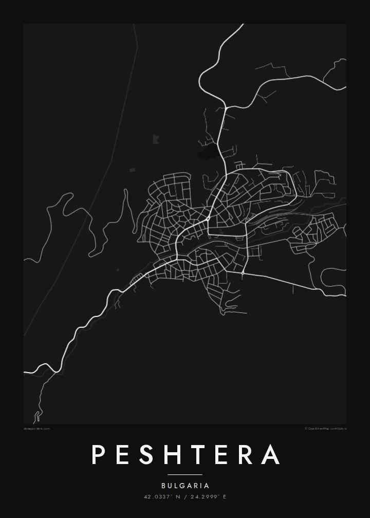
The streets stop sharply where the mountain begins. On the map, the edge between built-up land and steep slope is very clear.
Minimalista térképposzter · Bulgária
42.0337° N / 24.2999° E
A Bulgarian town at the northern foot of the Rhodopes, where streets end abruptly against steep wooded slopes



Egy város, öt hangulat
Koppints egy stílusra, hogy lásd a falon. Minden stílus ugyanannyiba kerül — nyomtatva, kerettel vagy HD fájlként.
 Valódi pixelek · 24 × 36″ nyomtatási fájl
Nyomtatásban is éles
Ez a valódi nyomtatási fájl 100%-os kivágata. Minden poszter — nyomtatva, kerettel vagy letöltve — szervereinken 300 DPI-vel, akár 7,200 × 10,800 pixel felbontásban készül, így a legkisebb utcák is élesek maradnak egy 24 × 36″-os nyomaton is.
A falon


A térkép
Peshtera sits where the Upper Thracian Plain meets the northern slopes of the Western Rhodopes, west of Plovdiv. Its name means cave in Bulgarian, which suits its surroundings. The show cave of Snezhanka lies in the hills just south of town, and the karst country around it holds more caves. Peshtera is also known across Bulgaria for its mastika, an anise-flavoured spirit.
The map shows a town pressed against the mountains. On its northern side, the streets spread out onto flatter land that opens towards the plain. To the south they climb, bend and then stop where the slopes grow too steep. A road leads up from the town into the Rhodopes towards Batak, winding in tight curves through the valley.
A Peshtera map poster captures that meeting of plain and mountain in simple black and white. It is a good print for people from the Pazardzhik region, for hikers who have used the town as a starting point, and for anyone who has visited the caves in the hills above it.
The streets stop sharply where the mountain begins. On the map, the edge between built-up land and steep slope is very clear.
A winding road climbs south towards Batak in a series of turns. It is the most distinctive line leaving the town.
To the north, the town opens onto flatter farmland. Straighter roads there lead towards Pazardzhik and the Thracian plain.
Tedd a sajátoddá
Adj hozzá dátumot, nevet vagy saját szöveget, válts stílust, méretet vagy tájolást.
Az ingyenes előnézet alacsony felbontású és vízjeles. A nyomatok és a HD fájlok 300 DPI-vel, akár 7,200 × 10,800 px felbontásban készülnek, vízjel nélkül.
Miért Peshtera?
Peshtera suits people who love the Rhodopes, those who grew up in the town, and anyone with good memories of the caves in its hills. Its setting against the mountain makes a strong composition.
Choose your title and subtitle, perhaps a family name or a year, and keep or adjust the coordinates line. Then pick Classic black & white, Noir, Paper, Blueprint or Sand.
Peshtera poszter megrendelése| Nyomtatási méret | Felbontás | Fájlok |
|---|---|---|
| 30 × 40 cm11.8 × 15.7″ | 3,543 × 4,724 px | PNG · PDF |
| 29.7 × 42 cm (A3)11.7 × 16.5″ | 3,508 × 4,961 px | PNG · PDF |
| 42 × 59.4 cm (A2)16.5 × 23.4″ | 4,961 × 7,016 px | PNG · PDF |
| 45.7 × 61 cm18 × 24″ | 5,400 × 7,200 px | PNG · PDF |
| 50 × 70 cm19.7 × 27.6″ | 5,906 × 8,268 px | PNG · PDF |
| 61 × 91.4 cm24 × 36″ | 7,200 × 10,800 px | PNG · PDF |
Összehasonlításképp: az ingyenes előnézet 900 px széles, vízjeles, és képernyőn való megtekintésre készült. A HD fájlok mindkét irányban akár 8× nagyobb felbontásúak, és teljes poszterméretben is tisztán nyomtathatók.
Válassz egy stílust az oldal tetején, majd válaszd a Nyomtatott poszter opciót — méretet és, ha szeretnéd, keretet is — vagy a Digitális HD fájlokat. A fizetés egy lépésből áll, és a rendelési oldalad azonnal frissül, amint a fizetés megtörtént.
Prémium, 200 g/m²-es matt papírra nyomtatjuk, hat méretben, 30 × 40 cm-től 24 × 36″-ig. A nyomtatott poszterek ára $39-tól indul, szállítással együtt.
Igen. Válassz tömör fa keretet fekete, fehér, natúr tölgy vagy sötét fa színben. Törésálló üvegezéssel érkezik, azonnal felakasztható. A keretezett poszterek ára $99-tól indul, szállítással együtt.
A szállítás 60+ országba ingyenes. Minden plakátot a hozzánk legközelebbi nyomdai partnerünk nyomtat ki, több mint 30 országban, és általában 3–7 munkanap alatt érkezik meg. Az állapotot és a követést a Rendeléseim menüpontban követheted nyomon. Néhány országba 2–5 hétig tart a szállítás, és ahová még nem szállítunk, ott az oldal fizetés előtt jelzi.
Küldj nekünk egy fotót a kézbesítéstől számított 14 napon belül, és ingyen újranyomtatjuk, vagy visszatérítjük az összeget.
Igen. Az oldalon található szerkesztőben tetszés szerint módosíthatod a címet, az alcímet és a koordináták sorát, majd válassz stílust és méretet. A nyomtatott, keretezett és digitális rendelések is pontosan a te tervedet használják.
$9-ért 300 DPI-s PNG és nyomtatásra kész PDF fájlokat kapsz mind a hat méretben, vízjel nélkül, bárhol kinyomtathatod. Még nem vagy biztos benne? Töltsd le először az ingyenes, vízjeles előnézetet.
A közelben
