Barak River meanders
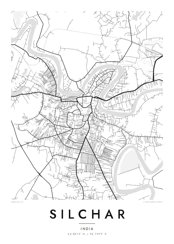
The river loops around the town in wide curves, framing the city on several sides and giving the map its most distinctive shape.
Minimalista térképposzter · India
24.8273° N / 92.7979° E
A river town in southern Assam, wrapped by the loops of the Barak River across a flat valley floor


Egy város, öt hangulat
Koppints egy stílusra, hogy lásd a falon. Minden stílus ugyanannyiba kerül — nyomtatva, kerettel vagy HD fájlként.
 Valódi pixelek · 24 × 36″ nyomtatási fájl
Nyomtatásban is éles
Ez a valódi nyomtatási fájl 100%-os kivágata. Minden poszter — nyomtatva, kerettel vagy letöltve — szervereinken 300 DPI-vel, akár 7,200 × 10,800 pixel felbontásban készül, így a legkisebb utcák is élesek maradnak egy 24 × 36″-os nyomaton is.
A falon


A térkép
Silchar is the main city of the Barak Valley in southern Assam, and the Barak River shapes nearly every part of its map. The river curves around the town in broad meanders, leaving low-lying land and oxbow lakes along its course. Streets fill the drier ground between the bends, while ponds and wetlands appear throughout the surrounding plain.
The city is the headquarters of Cachar district and a commercial centre for the valley. It holds a significant place in the history of the Bengali language movement: on 19 May 1961, protesters were killed at Silchar railway station while demonstrating for the recognition of Bengali, and the date is still commemorated as Language Martyrs' Day.
A Silchar map poster turns the river's loops into the defining feature of the composition. The flowing curves of the Barak contrast with the denser grid of the centre, producing an image that is organic, balanced and immediately tied to place.
The river loops around the town in wide curves, framing the city on several sides and giving the map its most distinctive shape.
The low-lying valley is dotted with ponds and marshy land, adding small scattered shapes around the urban area.
The station is tied to the language movement of 1961, and the rail line forms a clear stroke through the town's otherwise organic street pattern.
Tedd a sajátoddá
Adj hozzá dátumot, nevet vagy saját szöveget, válts stílust, méretet vagy tájolást.
Az ingyenes előnézet alacsony felbontású és vízjeles. A nyomatok és a HD fájlok 300 DPI-vel, akár 7,200 × 10,800 px felbontásban készülnek, vízjel nélkül.
Miért Silchar?
A map of Silchar holds the river, the town and the memory of home in one image. It suits families across India and abroad who trace their roots to the Barak Valley.
Personalise the title, add a subtitle in English or Bengali, and set the coordinates. Choose from Classic black and white, Noir, Paper, Blueprint or Sand, as $9 HD files or a printed poster.
Silchar poszter megrendelése| Nyomtatási méret | Felbontás | Fájlok |
|---|---|---|
| 30 × 40 cm (11.8 × 15.7″) | 3,543 × 4,724 px | PNG · PDF |
| 29.7 × 42 cm (A3, 11.7 × 16.5″) | 3,508 × 4,961 px | PNG · PDF |
| 42 × 59.4 cm (A2, 16.5 × 23.4″) | 4,961 × 7,016 px | PNG · PDF |
| 45.7 × 61 cm (18 × 24″) | 5,400 × 7,200 px | PNG · PDF |
| 50 × 70 cm (19.7 × 27.6″) | 5,906 × 8,268 px | PNG · PDF |
| 61 × 91.4 cm (24 × 36″) | 7,200 × 10,800 px | PNG · PDF |
Összehasonlításképp: az ingyenes előnézet 900 px széles, vízjeles, és képernyőn való megtekintésre készült. A HD fájlok mindkét irányban akár 8× nagyobb felbontásúak, és teljes poszterméretben is tisztán nyomtathatók.
Válassz egy stílust az oldal tetején, majd válaszd a Nyomtatott poszter opciót — méretet és, ha szeretnéd, keretet is — vagy a Digitális HD fájlokat. A fizetés egy lépésből áll, és a rendelési oldalad azonnal frissül, amint a fizetés megtörtént.
Prémium, 200 g/m²-es matt papírra nyomtatjuk, hat méretben, 30 × 40 cm-től 24 × 36″-ig. A nyomtatott poszterek ára {printFrom}-tól indul, szállítással együtt.
Igen. Válassz tömör fa keretet fekete, fehér, natúr tölgy vagy sötét fa színben. Törésálló üvegezéssel érkezik, azonnal felakasztható. A keretezett poszterek ára {framedFrom}-tól indul, szállítással együtt.
A szállítás világszerte ingyenes. Minden posztert a hozzád legközelebbi nyomdapartnerünk nyomtatja ki 30+ országban, és általában 3–7 munkanap alatt megérkezik. A státuszt és a nyomkövetést a Rendeléseim oldalon követheted.
Küldj nekünk egy fotót a kézbesítéstől számított 14 napon belül, és ingyen újranyomtatjuk, vagy visszatérítjük az összeget.
Igen. Az oldalon található szerkesztőben tetszés szerint módosíthatod a címet, az alcímet és a koordináták sorát, majd válassz stílust és méretet. A nyomtatott, keretezett és digitális rendelések is pontosan a te tervedet használják.
$9-ért 300 DPI-s PNG és nyomtatásra kész PDF fájlokat kapsz mind a hat méretben, vízjel nélkül, bárhol kinyomtathatod. Még nem vagy biztos benne? Töltsd le először az ingyenes, vízjeles előnézetet.
