Mahananda River
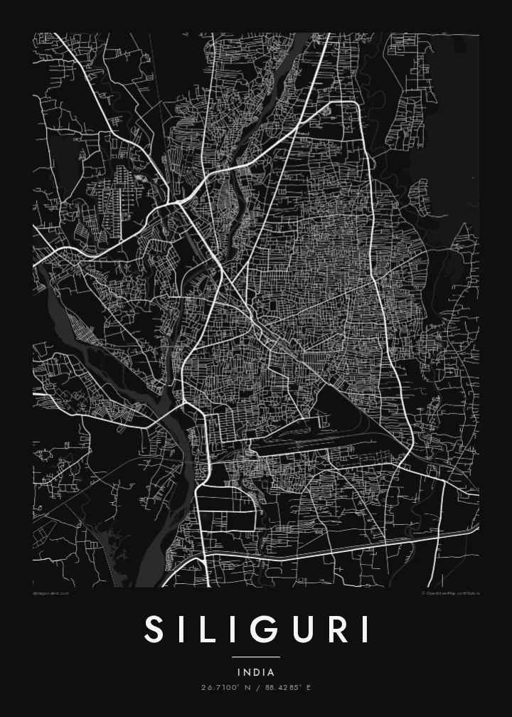
A wide, braided river bed cuts through the city from north to south, with bridges carrying the main roads across. It is the central feature of the poster.
Minimalista térképposzter · India
26.7100° N / 88.4285° E
A junction city at the foot of the Himalaya, spread along the Mahananda River in the narrow Siliguri Corridor



Egy város, öt hangulat
Koppints egy stílusra, hogy lásd a falon. Minden stílus ugyanannyiba kerül — nyomtatva, kerettel vagy HD fájlként.
 Valódi pixelek · 24 × 36″ nyomtatási fájl
Nyomtatásban is éles
Ez a valódi nyomtatási fájl 100%-os kivágata. Minden poszter — nyomtatva, kerettel vagy letöltve — szervereinken 300 DPI-vel, akár 7,200 × 10,800 pixel felbontásban készül, így a legkisebb utcák is élesek maradnak egy 24 × 36″-os nyomaton is.
A falon


A térkép
Siliguri lies where the plains of northern West Bengal meet the foothills of the Himalaya. It sits in the Siliguri Corridor, a narrow strip of Indian territory between Nepal and Bangladesh that links the northeastern states to the rest of the country. That strategic position has made it a key junction for roads, railways and trade.
The Mahananda River runs through the city from north to south, and its wide, braided bed is one of the strongest shapes on the map. Streets spread out on both sides, and major highways leave in several directions: north toward Darjeeling and Sikkim, east toward Assam and west toward Bihar and Nepal.
A Siliguri map poster also shows the rail lines that meet here. New Jalpaiguri station lies in the south of the urban area, and the narrow-gauge Darjeeling Himalayan Railway, a UNESCO World Heritage Site, begins its climb into the hills from this area. On the northern edge, streets thin out quickly as the land begins to rise toward the forests and tea gardens.
A wide, braided river bed cuts through the city from north to south, with bridges carrying the main roads across. It is the central feature of the poster.
Highways and rail lines converge here from several directions, giving the map a pattern of long, radiating lines from the city toward the hills and plains.
To the north the grid thins out as the land rises toward the Himalaya. The change from dense city to open, forested country is sharp.
Tedd a sajátoddá
Adj hozzá dátumot, nevet vagy saját szöveget, válts stílust, méretet vagy tájolást.
Az ingyenes előnézet alacsony felbontású és vízjeles. A nyomatok és a HD fájlok 300 DPI-vel, akár 7,200 × 10,800 px felbontásban készülnek, vízjel nélkül.
Miért Siliguri?
Siliguri is where many journeys to Darjeeling, Sikkim and the northeast begin, and it is home to many families from across the region. A map of the city marks both a place to live and a crossroads.
You can set the title, add a date or a note in the subtitle, and adjust the coordinates. Choose one of five styles; Blueprint shows the river and the rail lines clearly, and Noir gives the junction a strong, graphic look.
Siliguri poszter megrendelése| Nyomtatási méret | Felbontás | Fájlok |
|---|---|---|
| 30 × 40 cm11.8 × 15.7″ | 3,543 × 4,724 px | PNG · PDF |
| 29.7 × 42 cm (A3)11.7 × 16.5″ | 3,508 × 4,961 px | PNG · PDF |
| 42 × 59.4 cm (A2)16.5 × 23.4″ | 4,961 × 7,016 px | PNG · PDF |
| 45.7 × 61 cm18 × 24″ | 5,400 × 7,200 px | PNG · PDF |
| 50 × 70 cm19.7 × 27.6″ | 5,906 × 8,268 px | PNG · PDF |
| 61 × 91.4 cm24 × 36″ | 7,200 × 10,800 px | PNG · PDF |
Összehasonlításképp: az ingyenes előnézet 900 px széles, vízjeles, és képernyőn való megtekintésre készült. A HD fájlok mindkét irányban akár 8× nagyobb felbontásúak, és teljes poszterméretben is tisztán nyomtathatók.
Válassz egy stílust az oldal tetején, majd válaszd a Nyomtatott poszter opciót — méretet és, ha szeretnéd, keretet is — vagy a Digitális HD fájlokat. A fizetés egy lépésből áll, és a rendelési oldalad azonnal frissül, amint a fizetés megtörtént.
Prémium, 200 g/m²-es matt papírra nyomtatjuk, hat méretben, 30 × 40 cm-től 24 × 36″-ig. A nyomtatott poszterek ára $39-tól indul, szállítással együtt.
Igen. Válassz tömör fa keretet fekete, fehér, natúr tölgy vagy sötét fa színben. Törésálló üvegezéssel érkezik, azonnal felakasztható. A keretezett poszterek ára $99-tól indul, szállítással együtt.
A szállítás 60+ országba ingyenes. Minden plakátot a hozzánk legközelebbi nyomdai partnerünk nyomtat ki, több mint 30 országban, és általában 3–7 munkanap alatt érkezik meg. Az állapotot és a követést a Rendeléseim menüpontban követheted nyomon. Néhány országba 2–5 hétig tart a szállítás, és ahová még nem szállítunk, ott az oldal fizetés előtt jelzi.
Küldj nekünk egy fotót a kézbesítéstől számított 14 napon belül, és ingyen újranyomtatjuk, vagy visszatérítjük az összeget.
Igen. Az oldalon található szerkesztőben tetszés szerint módosíthatod a címet, az alcímet és a koordináták sorát, majd válassz stílust és méretet. A nyomtatott, keretezett és digitális rendelések is pontosan a te tervedet használják.
$9-ért 300 DPI-s PNG és nyomtatásra kész PDF fájlokat kapsz mind a hat méretben, vízjel nélkül, bárhol kinyomtathatod. Még nem vagy biztos benne? Töltsd le először az ingyenes, vízjeles előnézetet.
A közelben
