Coastal ribbon
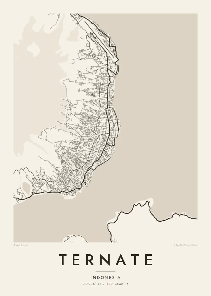
The city stretches in a narrow band along the eastern shore, with most streets confined between the sea and the steep volcanic slopes.
Minimalista térképposzter · Indonézia
0.7906° N / 127.3842° E
A volcanic island city strung along the shore, circling the slopes of Gamalama




Egy város, öt hangulat
Koppints egy stílusra, hogy lásd a falon. Minden stílus ugyanannyiba kerül — nyomtatva, kerettel vagy HD fájlként.
 Valódi pixelek · 24 × 36″ nyomtatási fájl
Nyomtatásban is éles
Ez a valódi nyomtatási fájl 100%-os kivágata. Minden poszter — nyomtatva, kerettel vagy letöltve — szervereinken 300 DPI-vel, akár 7,200 × 10,800 pixel felbontásban készül, így a legkisebb utcák is élesek maradnak egy 24 × 36″-os nyomaton is.
A falon


A térkép
Ternate is a small island in North Maluku almost entirely formed by the volcano Gamalama. On a map, the city occupies a narrow band along the eastern coast, with houses and streets pressed between the sea and the rising slopes. A ring road follows the shoreline around the island.
Inland, the streets quickly give way to the mountain, and the upper slopes appear largely empty. The waterfront has harbours and reclaimed areas, while old forts and the sultan's palace mark historic points along the shore. The shape of the island makes the map unusually self-contained.
Ternate was once one of the most important sources of cloves in the world, and its sultanate drew Portuguese and Dutch traders in the sixteenth and seventeenth centuries. Alfred Russel Wallace wrote his famous 1858 letter on natural selection while based here. A Ternate map poster shows an island city defined by volcano and sea.
The city stretches in a narrow band along the eastern shore, with most streets confined between the sea and the steep volcanic slopes.
A single road circles the island along the coast, drawing a clear loop that frames the mountain in the centre of the map.
The volcano rises from the middle of the island, leaving a large empty shape that dominates the composition and emphasises the coastal settlement.
Tedd a sajátoddá
Adj hozzá dátumot, nevet vagy saját szöveget, válts stílust, méretet vagy tájolást.
Az ingyenes előnézet alacsony felbontású és vízjeles. A nyomatok és a HD fájlok 300 DPI-vel, akár 7,200 × 10,800 px felbontásban készülnek, vízjel nélkül.
Miért Ternate?
Ternate is a place with a remarkable history, and its island shape makes an unusually strong poster. It suits people from Maluku, travellers who have visited the spice islands, and anyone interested in natural history.
Personalise the title, subtitle and coordinates, and choose one of five styles, including Noir and Blueprint. Buy the $9 HD files or order a printed matte poster, delivered with an optional wooden frame from partners in more than 30 countries.
Ternate poszter megrendelése| Nyomtatási méret | Felbontás | Fájlok |
|---|---|---|
| 30 × 40 cm (11.8 × 15.7″) | 3,543 × 4,724 px | PNG · PDF |
| 29.7 × 42 cm (A3, 11.7 × 16.5″) | 3,508 × 4,961 px | PNG · PDF |
| 42 × 59.4 cm (A2, 16.5 × 23.4″) | 4,961 × 7,016 px | PNG · PDF |
| 45.7 × 61 cm (18 × 24″) | 5,400 × 7,200 px | PNG · PDF |
| 50 × 70 cm (19.7 × 27.6″) | 5,906 × 8,268 px | PNG · PDF |
| 61 × 91.4 cm (24 × 36″) | 7,200 × 10,800 px | PNG · PDF |
Összehasonlításképp: az ingyenes előnézet 900 px széles, vízjeles, és képernyőn való megtekintésre készült. A HD fájlok mindkét irányban akár 8× nagyobb felbontásúak, és teljes poszterméretben is tisztán nyomtathatók.
Válassz egy stílust az oldal tetején, majd válaszd a Nyomtatott poszter opciót — méretet és, ha szeretnéd, keretet is — vagy a Digitális HD fájlokat. A fizetés egy lépésből áll, és a rendelési oldalad azonnal frissül, amint a fizetés megtörtént.
Prémium, 200 g/m²-es matt papírra nyomtatjuk, hat méretben, 30 × 40 cm-től 24 × 36″-ig. A nyomtatott poszterek ára $39-tól indul, szállítással együtt.
Igen. Válassz tömör fa keretet fekete, fehér, natúr tölgy vagy sötét fa színben. Törésálló üvegezéssel érkezik, azonnal felakasztható. A keretezett poszterek ára $99-tól indul, szállítással együtt.
A szállítás az egész világon ingyenes. Minden posztert a hozzánk legközelebb eső nyomdapartnerünk nyomtatja ki a több mint 30 országban működő hálózatunkból, és általában 3–7 munkanap alatt megérkezik. A rendelés állapotát és a csomagkövetést a Rendeléseim oldalon nézheted meg. Néhány országba 2–5 hét a szállítás, oda pedig, ahová még nem szállítunk, az oldal fizetés előtt szól.
Küldj nekünk egy fotót a kézbesítéstől számított 14 napon belül, és ingyen újranyomtatjuk, vagy visszatérítjük az összeget.
Igen. Az oldalon található szerkesztőben tetszés szerint módosíthatod a címet, az alcímet és a koordináták sorát, majd válassz stílust és méretet. A nyomtatott, keretezett és digitális rendelések is pontosan a te tervedet használják.
$9-ért 300 DPI-s PNG és nyomtatásra kész PDF fájlokat kapsz mind a hat méretben, vízjel nélkül, bárhol kinyomtathatod. Még nem vagy biztos benne? Töltsd le először az ingyenes, vízjeles előnézetet.
