Ria Formosa lagoon
Behind a line of narrow sandy islands lies a maze of tidal channels and marsh, drawn as fine branching water lines around Faro and Olhão.
Մինիմալիստական քարտեզ-պաստառ · Պորտուգալիա
37.2445° N / 8.1960° W
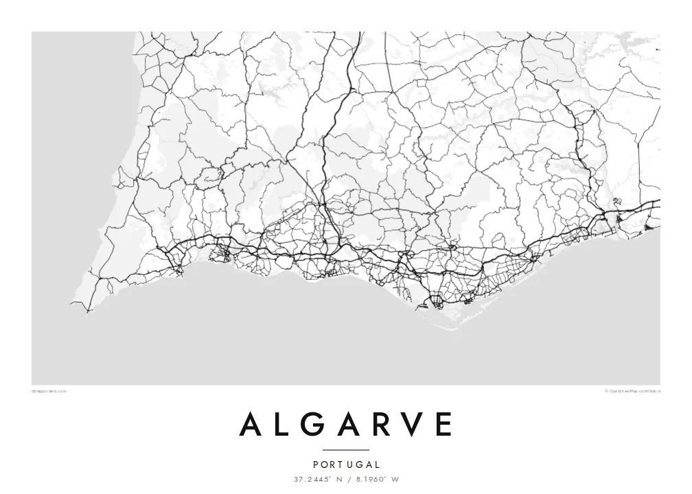
Portugal's southern edge, from barrier islands and lagoons in the east to carved cliffs and a sharp southwestern cape


Մեկ քաղաք, հինգ տրամադրություն
Հպեք ոճին՝ պատին տեսնելու համար։ Բոլոր ոճերն արժեն նույնը՝ տպված, շրջանակված կամ որպես HD ֆայլեր։
 Իրական պիքսելներ · 24 × 36″ տպագրական ֆայլ
Տպագրական հստակություն
Սա իրական տպագրական ֆայլի 100% հատվածն է։ Յուրաքանչյուր պաստառ՝ տպված, շրջանակված կամ ներբեռնված, մեր սերվերներում մշակվում է 300 DPI որակով, մինչև 7,200 × 10,800 պիքսել, այնպես որ նույնիսկ ամենանուրբ գծերը մնում են հստակ 24 × 36″ տպագրության վրա։
Պատին


Քարտեզը
The Algarve is the southernmost region of mainland Portugal, a long band of coast between the Guadiana river on the Spanish border and Cape St. Vincent. Its shape changes along the way. East of Faro the shore becomes a chain of sandy barrier islands, while west of Albufeira and around Lagos it breaks up into cliffs, arches and small coves.
The Ria Formosa, a protected lagoon behind the barrier islands, surrounds Faro, the regional capital, with marshes, channels and salt pans. At the far west, Sagres and Cape St. Vincent form the southwestern tip of mainland Europe, a place long associated with Portugal's age of sea exploration. Inland, the Serra de Monchique rises as a green range behind the coast.
An Algarve map poster puts these two coasts on one sheet: the soft lagoons and long sand spits in the east, and the ragged rock formations of Ponta da Piedade near Lagos in the west. Between them, towns such as Portimão sit at river mouths, and the streets of resort districts fill the low ground close to the shore.
Behind a line of narrow sandy islands lies a maze of tidal channels and marsh, drawn as fine branching water lines around Faro and Olhão.
South of Lagos the cliffs break up into sea stacks, arches and grottoes, giving this part of the coastline a jagged, finely detailed edge.
At the western end the coast turns sharply north at a bare headland, the corner where the south-facing shore meets Portugal's Atlantic west coast.
Դարձրեք այն ձերը
Ավելացրեք ամսաթիվ, անուն կամ ձեր սեփական տողը, փոխեք ոճը, չափսը կամ դիրքը։
Անվճար նախադիտումն ունի ցածր որակ և ջրանիշ։ Տպագրություններն ու HD ֆայլերը մշակվում են 300 DPI որակով, մինչև 7,200 × 10,800 px, առանց ջրանիշի։
Ինչու՝ Algarve
It works for families who have holidayed in the same resort for years and for people who have moved to the region. Write the town or the villa's name in the title, a year in the subtitle, and set the coordinates to your own stretch of beach.
Choose Sand for a sunlit feel, Blueprint for the lagoon's intricate channels, or Classic black & white, Noir and Paper. The poster is available as a $9 HD download or as a printed matte poster, framed in wood if you like.
Պատվիրել Algarve պաստառը| Տպագրության չափս | Լուծաչափ | Ֆայլեր |
|---|---|---|
| 30 × 40 cm11.8 × 15.7″ | 3,543 × 4,724 px | PNG · PDF |
| 29.7 × 42 cm (A3)11.7 × 16.5″ | 3,508 × 4,961 px | PNG · PDF |
| 42 × 59.4 cm (A2)16.5 × 23.4″ | 4,961 × 7,016 px | PNG · PDF |
| 45.7 × 61 cm18 × 24″ | 5,400 × 7,200 px | PNG · PDF |
| 50 × 70 cm19.7 × 27.6″ | 5,906 × 8,268 px | PNG · PDF |
| 61 × 91.4 cm24 × 36″ | 7,200 × 10,800 px | PNG · PDF |
Համեմատության համար՝ անվճար նախադիտումը 900 px լայնությամբ է, ջրանիշով և նախատեսված է էկրանների համար։ HD ֆայլերն ունեն մինչև 8 անգամ ավելի բարձր լուծաչափ յուրաքանչյուր ուղղությամբ և մաքուր են տպվում պաստառի ամբողջ չափով։
Ընտրեք ոճը էջի վերևում, ապա ընտրեք Տպված պաստառ՝ չափս և, ցանկության դեպքում, շրջանակ, կամ Թվային HD ֆայլեր։ Վճարումը կատարվում է մեկ քայլով, և ձեր պատվերի էջը թարմացվում է հենց վճարումն ավարտվելուն պես։
Այն տպվում է պրեմիում 200 գ/մ² մատ թղթի վրա՝ վեց չափսերից մեկով, 30 × 40 սմ-ից մինչև 24 × 36″։ Տպված պաստառների գինը սկսվում է $39-ից՝ առաքումը ներառված է։
Այո։ Ընտրեք զանգվածեղեն փայտից շրջանակ՝ սև, սպիտակ, բնական կաղնի կամ մուգ փայտի գույնով։ Այն ունի հարվածակայուն ապակի և պատրաստ է կախման համար։ Շրջանակված պաստառների գինը սկսվում է $99-ից՝ առաքումը ներառված է։
Առաքումն անվճար է 60+ երկրներ։ Յուրաքանչյուր պոստեր տպագրվում է 30+ երկրներում գործող մեր տպագրական գործընկերներից ամենամոտի մոտ և սովորաբար հասնում է 3–7 աշխատանքային օրում։ Կարգավիճակն ու հետևումը կարող եք տեսնել «Իմ պատվերները» բաժնում։ Մի քանի երկիր 2–5 շաբաթ է պահանջում, իսկ եթե դեռ չենք առաքում ձեր երկիր, կայքը դրա մասին կասի վճարելուց առաջ։
Ուղարկեք մեզ լուսանկար առաքումից հետո 14 օրվա ընթացքում, և մենք անվճար կրկին կտպենք կամ գումարը կվերադարձնենք։
Այո։ Այս էջի խմբագրիչում փոխեք վերնագիրը, ենթավերնագիրը և կոորդինատների տողը ձեր ցանկությամբ, և ընտրեք ոճն ու չափսը։ Տպված, շրջանակված և թվային պատվերներն օգտագործում են ճիշտ ձեր դիզայնը։
$9-ով ստանում եք 300 DPI որակի PNG և տպագրության համար պատրաստ PDF ֆայլեր բոլոր վեց չափսերով, առանց ջրանիշի, ցանկացած վայրում տպելու համար։ Դեռ վստահ չե՞ք։ Նախ ներբեռնեք անվճար ջրանիշով նախադիտումը։
