Mays Island
A narrow island in the Cedar River holding civic buildings, linked to both banks by bridges. On the poster it appears as a small block of streets floating in the middle of the water.
Մինիմալիստական քարտեզ-պաստառ · Միացյալ Նահանգներ
42.0083° N / 91.6441° W
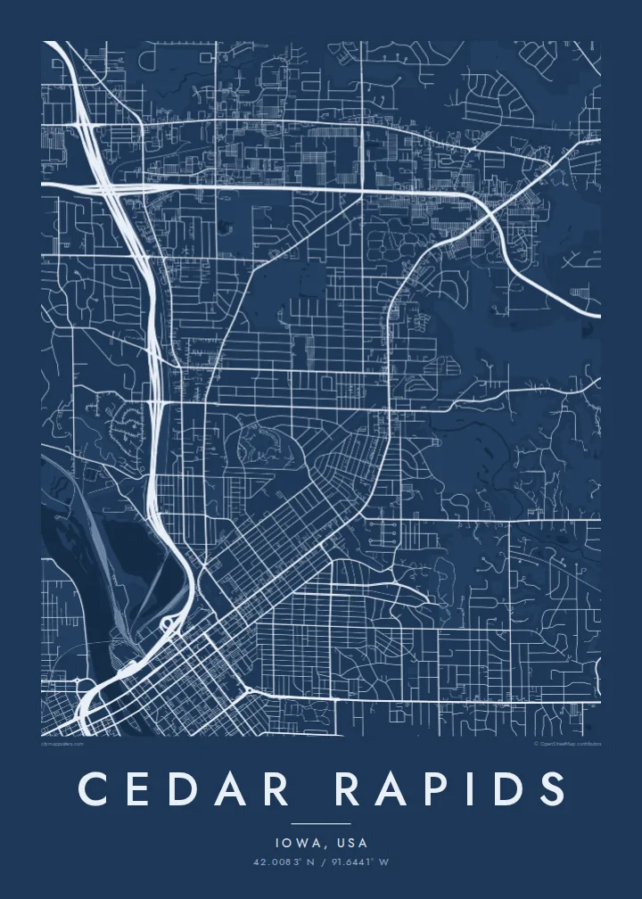
A river city split diagonally by the Cedar, with an island at its centre and four quadrants of numbered streets.



Մեկ քաղաք, հինգ տրամադրություն
Հպեք ոճին՝ պատին տեսնելու համար։ Բոլոր ոճերն արժեն նույնը՝ տպված, շրջանակված կամ որպես HD ֆայլեր։
 Իրական պիքսելներ · 24 × 36″ տպագրական ֆայլ
Տպագրական հստակություն
Սա իրական տպագրական ֆայլի 100% հատվածն է։ Յուրաքանչյուր պաստառ՝ տպված, շրջանակված կամ ներբեռնված, մեր սերվերներում մշակվում է 300 DPI որակով, մինչև 7,200 × 10,800 պիքսել, այնպես որ նույնիսկ ամենանուրբ գծերը մնում են հստակ 24 × 36″ տպագրության վրա։
Պատին


Քարտեզը
From above, Cedar Rapids is organised around the Cedar River, which cuts through the city from northwest to southeast. Streets and avenues are numbered and labelled by quadrant (NE, NW, SE and SW), so the map reads as four grids meeting at the water. Downtown sits on the east bank, and a series of bridges connects it to the west side and to Mays Island in the middle of the channel.
Mays Island is the detail most people remember. Civic buildings stand on it, which makes Cedar Rapids one of very few American cities with its seat of government on a river island. A short walk upstream, the large Quaker Oats plant reflects the city's long connection to grain processing, and on some days the smell of toasted oats drifts across downtown.
A Cedar Rapids map poster shows the whole arrangement at once: the river, the island, Interstate 380 curving through the centre and residential blocks spreading toward the farmland of eastern Iowa. The painter Grant Wood lived and worked here, and his ordered, clean-lined view of the Midwest suits the calm geometry of a black-and-white street map.
A narrow island in the Cedar River holding civic buildings, linked to both banks by bridges. On the poster it appears as a small block of streets floating in the middle of the water.
Numbered streets and avenues divide into NE, NW, SE and SW sections. The result is four slightly offset grids that meet along the river and give the map its structure.
The interstate runs north to south through the city and crosses the river close to downtown. Its long, smooth curves stand out against the square blocks on either side.
Դարձրեք այն ձերը
Ավելացրեք ամսաթիվ, անուն կամ ձեր սեփական տողը, փոխեք ոճը, չափսը կամ դիրքը։
Անվճար նախադիտումն ունի ցածր որակ և ջրանիշ։ Տպագրություններն ու HD ֆայլերը մշակվում են 300 DPI որակով, մինչև 7,200 × 10,800 px, առանց ջրանիշի։
Ինչու՝ Cedar Rapids
Cedar Rapids maps tend to go to people with a long attachment to the city: those who grew up in its quadrants, worked in its plants and offices, or helped rebuild after the 2008 flood. The river and the island make the layout recognisable even without labels.
The title, subtitle and coordinates line can all be personalised, for example with a family name or a date that matters, and the map comes in five styles: Classic black & white, Noir, Paper, Blueprint and Sand. Choose the $9 digital HD files or a printed poster with an optional wooden frame.
Պատվիրել Cedar Rapids պաստառը| Տպագրության չափս | Լուծաչափ | Ֆայլեր |
|---|---|---|
| 30 × 40 cm (11.8 × 15.7″) | 3,543 × 4,724 px | PNG · PDF |
| 29.7 × 42 cm (A3, 11.7 × 16.5″) | 3,508 × 4,961 px | PNG · PDF |
| 42 × 59.4 cm (A2, 16.5 × 23.4″) | 4,961 × 7,016 px | PNG · PDF |
| 45.7 × 61 cm (18 × 24″) | 5,400 × 7,200 px | PNG · PDF |
| 50 × 70 cm (19.7 × 27.6″) | 5,906 × 8,268 px | PNG · PDF |
| 61 × 91.4 cm (24 × 36″) | 7,200 × 10,800 px | PNG · PDF |
Համեմատության համար՝ անվճար նախադիտումը 900 px լայնությամբ է, ջրանիշով և նախատեսված է էկրանների համար։ HD ֆայլերն ունեն մինչև 8 անգամ ավելի բարձր լուծաչափ յուրաքանչյուր ուղղությամբ և մաքուր են տպվում պաստառի ամբողջ չափով։
Ընտրեք ոճը էջի վերևում, ապա ընտրեք Տպված պաստառ՝ չափս և, ցանկության դեպքում, շրջանակ, կամ Թվային HD ֆայլեր։ Վճարումը կատարվում է մեկ քայլով, և ձեր պատվերի էջը թարմացվում է հենց վճարումն ավարտվելուն պես։
Այն տպվում է պրեմիում 200 գ/մ² մատ թղթի վրա՝ վեց չափսերից մեկով, 30 × 40 սմ-ից մինչև 24 × 36″։ Տպված պաստառների գինը սկսվում է $39-ից՝ առաքումը ներառված է։
Այո։ Ընտրեք զանգվածեղեն փայտից շրջանակ՝ սև, սպիտակ, բնական կաղնի կամ մուգ փայտի գույնով։ Այն ունի հարվածակայուն ապակի և պատրաստ է կախման համար։ Շրջանակված պաստառների գինը սկսվում է $99-ից՝ առաքումը ներառված է։
Առաքումն ամբողջ աշխարհում անվճար է։ Յուրաքանչյուր պոստեր տպվում է մեր տպագրական գործընկերներից ամենամոտի մոտ՝ 30+ երկրներում, և սովորաբար հասնում է 3–7 աշխատանքային օրում։ Կարգավիճակն ու հետևման համարը կարող եք տեսնել «Իմ պատվերները» բաժնում։ Մի քանի երկրներ 2–5 շաբաթ են պահանջում, իսկ եթե դեռ չենք առաքում, կայքը դրա մասին կասի մինչև վճարելը։
Ուղարկեք մեզ լուսանկար առաքումից հետո 14 օրվա ընթացքում, և մենք անվճար կրկին կտպենք կամ գումարը կվերադարձնենք։
Այո։ Այս էջի խմբագրիչում փոխեք վերնագիրը, ենթավերնագիրը և կոորդինատների տողը ձեր ցանկությամբ, և ընտրեք ոճն ու չափսը։ Տպված, շրջանակված և թվային պատվերներն օգտագործում են ճիշտ ձեր դիզայնը։
$9-ով ստանում եք 300 DPI որակի PNG և տպագրության համար պատրաստ PDF ֆայլեր բոլոր վեց չափսերով, առանց ջրանիշի, ցանկացած վայրում տպելու համար։ Դեռ վստահ չե՞ք։ Նախ ներբեռնեք անվճար ջրանիշով նախադիտումը։
Մոտակայքում
