Niger–Benue confluence
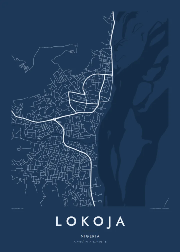
The meeting of Nigeria's two largest rivers dominates the map, a broad Y of open water with sandbars and islands that makes the town's position instantly recognisable.
Մինիմալիստական քարտեզ-պաստառ · Նիգերիա
7.7969° N / 6.7405° E
Two great rivers meet in a wide Y beneath a flat-topped hill, with the town strung along the western bank.



Մեկ քաղաք, հինգ տրամադրություն
Հպեք ոճին՝ պատին տեսնելու համար։ Բոլոր ոճերն արժեն նույնը՝ տպված, շրջանակված կամ որպես HD ֆայլեր։
 Իրական պիքսելներ · 24 × 36″ տպագրական ֆայլ
Տպագրական հստակություն
Սա իրական տպագրական ֆայլի 100% հատվածն է։ Յուրաքանչյուր պաստառ՝ տպված, շրջանակված կամ ներբեռնված, մեր սերվերներում մշակվում է 300 DPI որակով, մինչև 7,200 × 10,800 պիքսել, այնպես որ նույնիսկ ամենանուրբ գծերը մնում են հստակ 24 × 36″ տպագրության վրա։
Պատին


Քարտեզը
Lokoja sits where the Niger and the Benue join, and on a map that confluence is the whole composition. Two broad channels arrive from the north-west and north-east, merge into a single river flowing south, and leave sandbanks and braided islands in their wake. The town itself runs along the west bank in a narrow band, held between the water and the rising ground behind it.
Above the streets, Mount Patti climbs steeply, its plateau top reached by winding roads and tracks. The hill is tied to a widely told story: the name Nigeria is said to have been coined while looking out over this confluence. Lokoja also served as an early administrative centre under British rule, and today it is the capital of Kogi State, a crossroads between the north and south of the country.
A Lokoja map poster reduces all of this to line and space: the dense streets near the river, the highway threading north towards Abuja, and the pale expanse of water that fills much of the frame. Few city maps are so clearly organised around one natural event, and the result reads almost like a diagram of how rivers shape the places that grow beside them.
The meeting of Nigeria's two largest rivers dominates the map, a broad Y of open water with sandbars and islands that makes the town's position instantly recognisable.
The steep hill rising directly behind the town appears as a tight knot of winding roads, a strong contrast to the flat river plain spread out below it.
Squeezed between hill and water, Lokoja's streets form a long, narrow band that follows the west bank, with newer growth pushing along the main roads.
Դարձրեք այն ձերը
Ավելացրեք ամսաթիվ, անուն կամ ձեր սեփական տողը, փոխեք ոճը, չափսը կամ դիրքը։
Անվճար նախադիտումն ունի ցածր որակ և ջրանիշ։ Տպագրություններն ու HD ֆայլերը մշակվում են 300 DPI որակով, մինչև 7,200 × 10,800 px, առանց ջրանիշի։
Ինչու՝ Lokoja
For people from Kogi State, or anyone who has crossed the confluence, this map holds a sense of arrival: the point where two rivers and several highways come together. It works as a quiet reminder of home, a posting, a journey or a family story tied to the town.
You can set your own title, subtitle and coordinates line, adding a date or a name, and choose from Classic black & white, Noir, Paper, Blueprint or Sand. The HD files cost $9 and arrive without a watermark, or you can order a matte print from partners in more than 30 countries.
Պատվիրել Lokoja պաստառը| Տպագրության չափս | Լուծաչափ | Ֆայլեր |
|---|---|---|
| 30 × 40 cm11.8 × 15.7″ | 3,543 × 4,724 px | PNG · PDF |
| 29.7 × 42 cm (A3)11.7 × 16.5″ | 3,508 × 4,961 px | PNG · PDF |
| 42 × 59.4 cm (A2)16.5 × 23.4″ | 4,961 × 7,016 px | PNG · PDF |
| 45.7 × 61 cm18 × 24″ | 5,400 × 7,200 px | PNG · PDF |
| 50 × 70 cm19.7 × 27.6″ | 5,906 × 8,268 px | PNG · PDF |
| 61 × 91.4 cm24 × 36″ | 7,200 × 10,800 px | PNG · PDF |
Համեմատության համար՝ անվճար նախադիտումը 900 px լայնությամբ է, ջրանիշով և նախատեսված է էկրանների համար։ HD ֆայլերն ունեն մինչև 8 անգամ ավելի բարձր լուծաչափ յուրաքանչյուր ուղղությամբ և մաքուր են տպվում պաստառի ամբողջ չափով։
Ընտրեք ոճը էջի վերևում, ապա ընտրեք Տպված պաստառ՝ չափս և, ցանկության դեպքում, շրջանակ, կամ Թվային HD ֆայլեր։ Վճարումը կատարվում է մեկ քայլով, և ձեր պատվերի էջը թարմացվում է հենց վճարումն ավարտվելուն պես։
Այն տպվում է պրեմիում 200 գ/մ² մատ թղթի վրա՝ վեց չափսերից մեկով, 30 × 40 սմ-ից մինչև 24 × 36″։ Տպված պաստառների գինը սկսվում է $39-ից՝ առաքումը ներառված է։
Այո։ Ընտրեք զանգվածեղեն փայտից շրջանակ՝ սև, սպիտակ, բնական կաղնի կամ մուգ փայտի գույնով։ Այն ունի հարվածակայուն ապակի և պատրաստ է կախման համար։ Շրջանակված պաստառների գինը սկսվում է $99-ից՝ առաքումը ներառված է։
Առաքումն անվճար է 60+ երկրներ։ Յուրաքանչյուր պոստեր տպագրվում է 30+ երկրներում գործող մեր տպագրական գործընկերներից ամենամոտի մոտ և սովորաբար հասնում է 3–7 աշխատանքային օրում։ Կարգավիճակն ու հետևումը կարող եք տեսնել «Իմ պատվերները» բաժնում։ Մի քանի երկիր 2–5 շաբաթ է պահանջում, իսկ եթե դեռ չենք առաքում ձեր երկիր, կայքը դրա մասին կասի վճարելուց առաջ։
Ուղարկեք մեզ լուսանկար առաքումից հետո 14 օրվա ընթացքում, և մենք անվճար կրկին կտպենք կամ գումարը կվերադարձնենք։
Այո։ Այս էջի խմբագրիչում փոխեք վերնագիրը, ենթավերնագիրը և կոորդինատների տողը ձեր ցանկությամբ, և ընտրեք ոճն ու չափսը։ Տպված, շրջանակված և թվային պատվերներն օգտագործում են ճիշտ ձեր դիզայնը։
$9-ով ստանում եք 300 DPI որակի PNG և տպագրության համար պատրաստ PDF ֆայլեր բոլոր վեց չափսերով, առանց ջրանիշի, ցանկացած վայրում տպելու համար։ Դեռ վստահ չե՞ք։ Նախ ներբեռնեք անվճար ջրանիշով նախադիտումը։
Մոտակայքում
